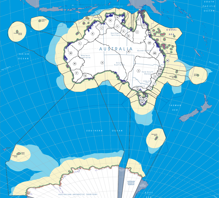
Possible Regional & Political Boundaries in Australia
The Future Shape of Australia
The Flow of Water Top of Ridge (FOWTOR) model demonstrates one form, one possible future for Australia. If we step back as a nation we might be able to envisage a new range of future possibilities. Spend a moment considering the diversity of Australasia and interconnections between localities by browsing the FOWTOR model. Click on your town on the map, or type your town's name in the Search engine.


© Commonwealth of Australia (Geoscience Australia) 2012.
With the exception of the Commonwealth Coat of Arms and where otherwise noted, this product is provided under a
Creative Commons Attribution 3.0 Australia Licence. http://creativecommons.org/licenses/by/3.0/legalcode
- S-5 Murray-Darling Basin Foreshore Sub-region (S5)
- S-2 MIA Sub-region (S2)
- R-8 Sandy Hollow Region (Z)
- R-5 Boonah Region (AC)
- R-30 Carpentaria Region (C)
- R-28 Borroloola Region (E)
- R-25 Van Diemen Region (H)
- R-22 Marapikurrinya Region (L)
- R-2 Mareeba Region (AG)
- R-17 Great Australian Bight Region (X)
- R-14 Wonthaggi Region (O)
- R-11 Portland Region (V)
- Home
- S-4 Murray River Sub-region (S4)
- S-1 Darling River Sub-region (S1)
- R-7 New England Region (AA)
- R-4 Capricorn Region (AE)
- R-3 Charters Region (AF)
- R-27 Mataranka Region (F)
- R-24 Wyndham Region (J)
- R-21 Murujuga Region (M)
- R-19 Kwinana Region (P)
- R-16 Uluru Central Region (R)
- R-13 Sandy Cove Region (U)
- R-10 Cape Howe Region (T)
- S-3 Snowy Mountains Sub-region (S3)
- R-9 Narrabeen Region (Y)
- R-6 Casino Region (AB)
- R-31 Keer-Weer Region (B)
- R-29 Wurung Region (D)
- R-26 East Arnhem Region (G)
- R-23 Fitzroy Crossing Region (K)
- R-20 Meekatharra Region (N)
- R-18 Nyabing Region (Q)
- R-15 Menindee Region (S)
- R-12 SE Cape Region (W)
- R-1 Cook Region (A)