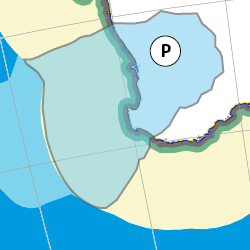
|
Capital: |
Perth 1.74 million approx Perth 15K key elements |
|
Others: |
Armadale Joondalup Byford Canning Vale Rockingham Mandurah Manjimup Fremantle Bunbury Kwinana 30,433 Margaret River 4,415 Kalamunda 6,835 Heirisson Island Matagarup |
|
Super region: |
None |
| Hospital: | http://www.myhospitals.gov.au/browse/wa/perth |
|
University: |
http://www.australian-universities.com/directory/perth-universities/ |
| Airport: | http://www.perthairport.com.au/ |
|
Basin Authority: |
Swan Margaret Basin Authority (SMBA)
|
Thanks for checking this Region out.
This Region is prepared on the a-political concept that if you are interested in 'place' in Australia, the most important aspect that defines 'place', is the 'flow of water'. The Senate is interested in 'place'.
This Region defines its boundaries at the top of the ridge, where water flows one way rather than the other. This leads to a very interesting 'place'.
We are seeking a debate with people who live in this proposed new Region. We know we've got the Region pretty well correct; after all, it's just geography. But if you live in this Region you can tell us a lot of interesting things.
- Do these boundaries define a place that is unique; different to every other Region in Australia? We think that that is probably quite likely.
- Is it a great place, worthy of recognition?
- Upon formation, what should be the name of this Region? Who would be the Lord Mayor? Who would be the two Senators who represent this Region? Who would be the additional Senator that represents the interests of Aboriginal & Torres Strait Islander peoples in this region?
- Would life be enhanced if it was on a fast Ring-Rail that links the Capital City to every other Capital City in Australia?
- Many other interesting things!
We think that this is a great new concept of regional statehood based on real concepts that define life in this particular Region. What do you think?
Land projected to be below annual flood level in 2050
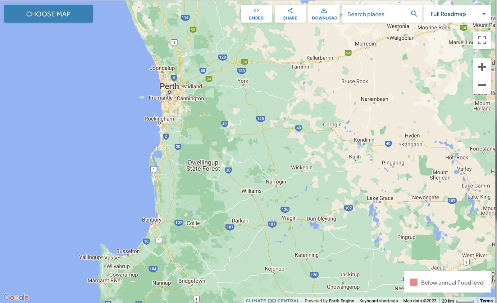
Comparison: long-term sea level outcomes
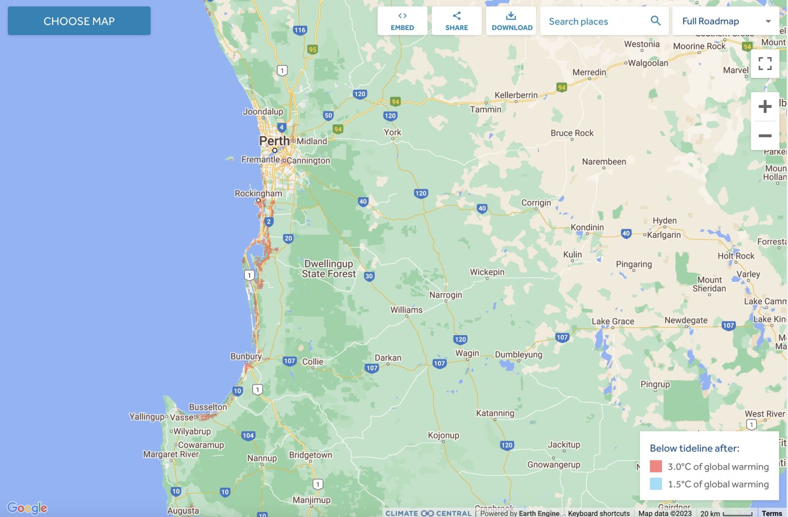
Comparison: long-term sea level outcomes
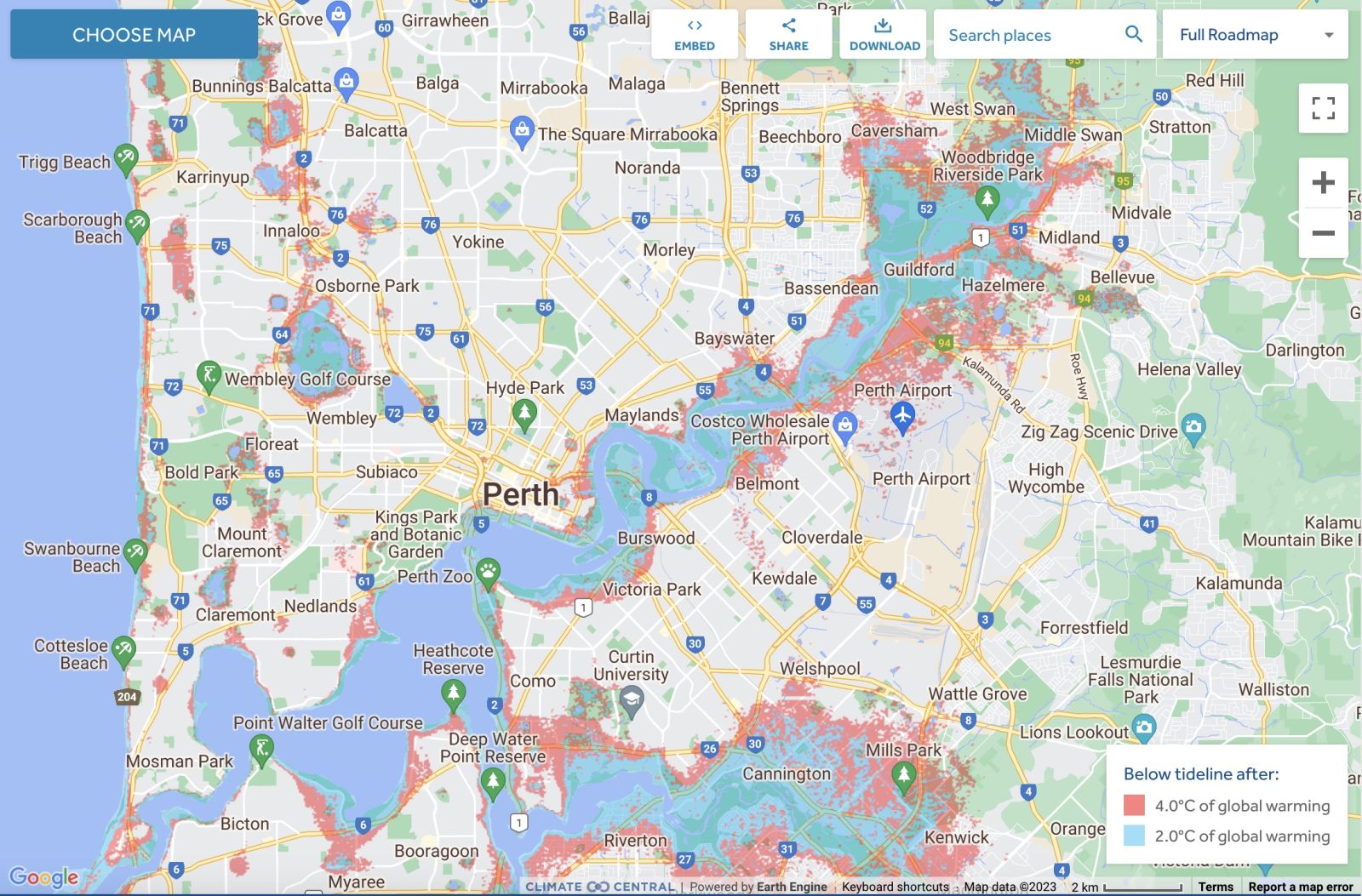
|
Aboriginal Australia:
|
|
|
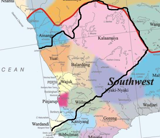
NOTE1: Likely indicators only; for original Aboriginal Australia Map © 1991 & restrictions on its copy & use, see Aboriginal Australia Map NOTE2: The red line is part of the original Aboriginal Australia Map © 1991. The black line is added by Bloggerme for discussion only. It shows the likely State boundary based on the flow of water only. As "the ridge" (See FOWTOR) naturally impacts on the development of the language, social or nation groups of the Indigenous people of Australia, the proposed border is often identical to the group boundary shown on the Aboriginal Australia Map. This is as was expected. Variations are social/historical & result in a particular language, social or nation group being represented in two adjoining States. |
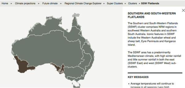 |
Other regional projections - CSIRO part of Southern & South-Western Flatlands regionThe CSIRO has regions for projecting the impact of Climate Change. See https://www.climatechangeinaustralia.gov.au/en/climate-projections/futur... This state, Kwinana State (P), is one of the clear projections in a CSIRO cluster called "Southern & South-Western Flatlands region". CSIRO's Southern & South-Western Flatlands region coincides with BloggerMe's N,P,Q, and a tiny bit of X and a tiny bit of R. |
Nuclear weapons
Centre ground zero CGZ - Perth - 475 kilotons (431 kilotonnes)
https://nuclearsecrecy.com/nukemap/
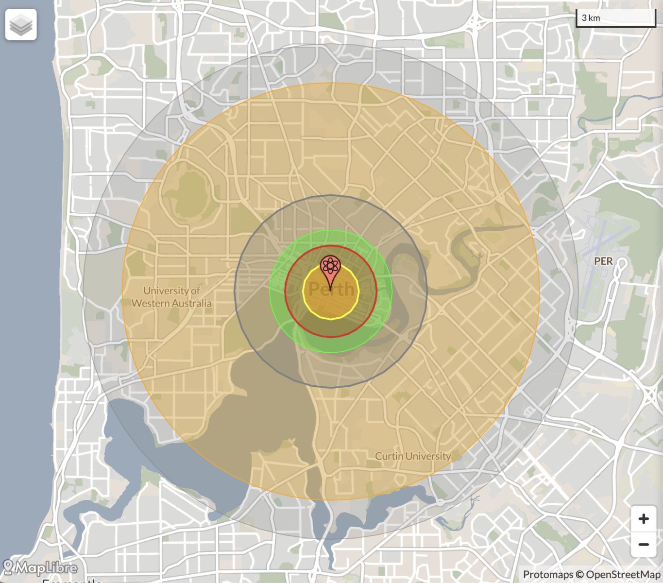
NB: population 10km around Perth CBD LEGEND
https://australia.places-in-the-world.com/11523824-places-within-10km-ar...
Population taken out by nuclear weapon = 518,172
Click here to:

Comments
Steve Irons
Thu, 08/10/2020 - 2:37pm
Permalink
Beauty
Margaret River
https://www.pinterest.com/pin/418553359094141988/
Point Peron, Cape Peron
https://www.pinterest.com/pin/418553359093991467/
Dawesville, Mandurah
https://www.pinterest.com/pin/418553359094047346/
Cape Leeuwin
https://www.pinterest.com/pin/418553359094142017/
Wave Rock formation near the town of Hyden
https://www.pinterest.com/pin/418553359094183241/
Wave Rock formation near the town of Hyden https://www.pinterest.com/pin/418553359094183255/
Serpentine Falls, Serpentine Falls National Park
https://www.pinterest.com/pin/418553359094047176/
King's Park Lake, Perth
https://www.pinterest.com/pin/418553359094491047/
Nambung National Park
https://www.pinterest.com/pin/418553359094491166/
Margaret River
https://www.pinterest.com/pin/418553359094658976/
Problems in Heirisson Island Matagarup an island in the Swan River
https://www.pinterest.com/pin/418553359095009878/
West End, Rottnest Island
https://www.pinterest.com/pin/418553359095020399/
SaltLakes, in the Wheatbelt
https://www.pinterest.com/pin/418553359095228536/
Perth, now 2 million residents
https://www.pinterest.com/pin/418553359095258320/
Perth, under the bridge nighttime
https://www.pinterest.com/pin/418553359095271550/
Swan River, Narrows Bridge & Perth city
https://www.pinterest.com/pin/418553359095565391/
Yalingup, & the surf's up!
https://www.pinterest.com/pin/418553359096427732/
Surf's up: Margaret River
https://www.pinterest.com/pin/418553359096442471/
Rottnest Island
https://www.pinterest.com/pin/418553359097845205/
Perth
https://www.pinterest.com/pin/418553359099087368/
Conversation
Sat, 06/04/2013 - 3:23am
Permalink
Australian endangered species: Hairy Marron
"... the Hairy Marron is restricted to the Margaret River. The Hairy Marron is aptly named for the tufts of hair-like setae that cover its shell. [...]
"Hairy Marron are unfortunately declining rapidly in their natural habitat, mainly due to competition with Smooth Marron which invaded the Margaret River some time during the early 1980s. Crayfish geneticist Chris Austin sampled sites in the Margaret River and found Smooth Marron for the first time in 1985. By 1998 there were no Hairy Marron. It is not known how Smooth Marron invaded the Margaret River, but translocation by humans seems likely.
"The Hairy Marron is now virtually absent from the lower reaches of the river downstream of Margaret River township, completely absent from the middle reaches in farmland, and still present in pools of the upper reaches in relatively undisturbed woodland. It was estimated in 2004 that less than 10,000 individuals were left in the wild."
Annette Koenders Senior Lecturer at Edith Cowan University: The Conversation 4 April 2013, 11.16am AEST
Read more: https://theconversation.com/australian-endangered-species-hairy-marron-1...
Conversation
Sat, 06/04/2013 - 3:17am
Permalink
The plight of Australia’s threatened freshwater mussels
"Already, mussels have disappeared from many streams in eastern Australia from loss of catchment vegetation in association with agricultural development. The habitats in many streams have become degraded from channel erosion and sedimentation. Increased nutrient loads in runoff, loss of shading vegetation and invasive water plants like Salvinia molesta and water hyacinth (Eichhornia spp.) have badly affected mussels in some parts of Australia. [...]
"In the mid-1990s, Carter’s Freshwater Mussel (Westralunio carteri) in south-western Western Australia was listed as “Vulnerable” on the IUCN Red List and recognised as a “Priority 4” species (a species in need of monitoring) by the WA Department of Environment and Conservation and, more recently, nominated for listing under EPBC criteria following a four-year study at Murdoch University. "
Michael Klunzinger Dr - Honorary Research Associate - School of Veterinary and Life Sciences at Murdoch University: The Conversation 4 April 2013, 2.24pm AEST
Read more: https://theconversation.com/in-muddy-waters-the-plight-of-australias-thr...
Twitter
Fri, 25/01/2013 - 12:20am
Permalink
Tax law reform
ILC UNSW @ILC_UNSW
OZ must reform tax laws that stop Indigenous people from benefitting from mining boom: leading scholar @marcialangton http://www.nit.com.au/news/2320-marcia-langton-urgent-call-for-indigenous-tax-reform-in-mining.html …
Twitter
Fri, 18/01/2013 - 7:03pm
Permalink
Bunbury = Family friendly city no 8
vexnews @vexnews
Tassie's Launceston most family friendly city in Australia http://bit.ly/W4hVlJ
Twitter
Fri, 18/01/2013 - 6:59pm
Permalink
Perth = Family friendly city no 5
vexnews @vexnews
Tassie's Launceston most family friendly city in Australia http://bit.ly/W4hVlJ
Twitter
Thu, 17/01/2013 - 2:48am
Permalink
DV Legal service
ILC UNSW @ILC_UNSW
WA aboriginal lawyer Hannah McGlade: decision to fund metro DV legal service is "momentous day for Perth" http://www.watoday.com.au/wa-news/new-service-a-stand-against-aboriginal-inequalities-20130113-2cnam.html …
Twitter
Thu, 10/01/2013 - 3:44am
Permalink
Perth housing
vexnews @vexnews
More coming to West Australia, but where can they live? Perth housing market squeezed. http://bit.ly/WqJLGx
Twitter
Sat, 29/12/2012 - 8:20am
Permalink
Wastewater
Meredith Stanton @CloudsCreek
CSIRO: Managed aquifer recharge: turning wastewater into a resource http://www.csiro.au/en/Organisation-Structure/Flagships/Water-for-a-Healthy-Country-Flagship/Urban-Water/Managed-Aquifer-Recharge.aspx … #water #mining #MAR (simple, but is it #safe?)
Twitter
Sat, 29/12/2012 - 7:05am
Permalink
Perth
vexnews @vexnews
Perth swelters through Christmas scorcher http://bit.ly/WD8Lgz
Twitter
Sat, 22/12/2012 - 10:50pm
Permalink
Canning Vale
vexnews @vexnews
It was the end of an era when "last drinks" were officially called at the Swan Brewery yesterday http://bit.ly/VTsuWN
Twitter
Wed, 12/12/2012 - 3:44am
Permalink
Secret Harbour
CSIRO @CSIROnews
Blog: Our scientists look for a break in the surf zone http://ow.ly/fToQR
Twitter
Thu, 06/12/2012 - 5:55am
Permalink
Rising sea levels
Ben Cubby @bencubby
Sea levels off Perth are rising at three times the global average rate. http://bit.ly/Sw9yij #climate
Twitter
Mon, 03/12/2012 - 2:28am
Permalink
Fremantle
FarmOnline @FarmOnline
Boost for young bush doctors: JAMES Roth had not always intended to be a doctor but it was his experiences in ru... http://bit.ly/11wlAvI
Twitter
Sat, 01/12/2012 - 4:54am
Permalink
modest house on the Perth coast
Ben Cubby @bencubby
Is there a better young columnist in the country than this guy? Can't think of one. http://bit.ly/X1KOTf
Twitter
Thu, 29/11/2012 - 6:14am
Permalink
Perth's geothermal resources
CSIRO @CSIROnews
How can underground water can be used to heat and cool an entire office block? Check this out http://ow.ly/fD3hv
Twitter
Fri, 23/11/2012 - 8:53pm
Permalink
Kalamunda
Ken Wyatt MP @KenWyattMP
Glad to see the hard work by Kalamunda #MensShed team pay off with the official opening of the new 'shed' today! http://ow.ly/i/19Yij
Twitter
Tue, 20/11/2012 - 3:54am
Permalink
Gage
FarmOnline @FarmOnline
Woolies signs deal with WA brewer: WOOLWORTHS has signed a three-year supply deal with craft beer company Gage R... http://bit.ly/10b3nDw
Twitter
Fri, 16/11/2012 - 9:51pm
Permalink
RDA Blogs - Peppermint Grove
myregion website @myregionGovAu
Public call for #green features gains results for #local #government award-winning The Grove. http://ow.ly/fkPaw
Twitter
Thu, 08/11/2012 - 2:24am
Permalink
Jarrah Forest bushfire
CSIRO @CSIROnews
RT @snwa: New research better #predicts #bushfire direction and spread http://ow.ly/f34t9
Twitter
Tue, 06/11/2012 - 2:21am
Permalink
Kwinana
Top End Tweets @TopEndTweets
http://indigenous.gov.au : Local Solutions Fund http://j.mp/RJr9k3
Steve Irons
Fri, 02/11/2012 - 11:32pm
Permalink
RDA Blogs - Cockburn
http://myregion.gov.au/blogs/city-cockburn-wa-nalg-national-winner-2011
Steve Irons
Fri, 02/11/2012 - 10:26pm
Permalink
RDA Blogs - South West
http://myregion.gov.au/blogs/south-west-ramblings-%E2%80%93-personal-jou...
Steve Irons
Fri, 02/11/2012 - 9:11pm
Permalink
RDA Blogs - Wheatbelt
http://myregion.gov.au/blogs/supporting-wheatbelt-youth
(Editor: http://www.rdawheatbelt.com.au/Portals/75/RDA/RDA_WAWheatbeltMap.pdf
http://www.rdawheatbelt.com.au/
Twitter
Wed, 31/10/2012 - 1:08pm
Permalink
Homelessness in Swan
Homelessness Aus @HomelessnessAus
New report released @AHURI_Research: Indigenous house crowding http://bit.ly/RrKGsy New ABS def found nearly 30% of h'less pop is Indigenous
Twitter
Mon, 29/10/2012 - 3:51am
Permalink
Rush Hour
City of Fremantle @CityofFremantle
Rush Hour: Swing, motown, latin, rock and pop, Rush Hour has it all. http://bit.ly/SPk8zI
Twitter
Wed, 24/10/2012 - 1:51pm
Permalink
Perth councils
Tweeting Roo ™ @TweetingRoo
A major shake-up planned of #Perth councils - ABC-online http://shrtn.in/2Mp6Nz
Twitter
Wed, 24/10/2012 - 6:26am
Permalink
Margaret R region
myregion website @myregionGovAu
Invitation to WA surfers to help select public #art at #Margaret River @Surfing_WA http://ow.ly/e9354
Steve Irons
Thu, 18/10/2012 - 4:44am
Permalink
A ROUGH DRAFT
Steve Irons
Sat, 13/10/2012 - 1:18am
Permalink
I'll put the links here for starters
https://twitter.com/esseeeayeenn/status/256748436093808640/photo/1
https://twitter.com/esseeeayeenn/status/256747331586768896/photo/1
https://twitter.com/esseeeayeenn/status/256747086916247552/photo/1
https://twitter.com/esseeeayeenn/status/256747154645856256/photo/1
https://twitter.com/esseeeayeenn/status/256747232664092673/photo/1
Add new comment