| Capital: | Port Macquarie 47,973 https://en.wikipedia.org/wiki/Port_Macquarie |
| Other: |
Armidale 29,317 Crescent Head 1,586 Kempsey 15,309 Taree 26,381 Wingham 5,395 Uralla 2,388 Wauchope 7,500 |
|
Super region: |
None |
|
University: |
YES - Armidale University http://www.une.edu.au/ |
|
Airport: |
|
|
TOR: |
Great Dividing Range |
|
Basin Authority: |
Manning McLeay Basin Authority (MMBA)
http://www.bom.gov.au/nsw/lord_howe/ Salisbury Waters and Bakers Creek |
Thanks for checking this Region out.
This Region is prepared on the a-political concept that if you are interested in 'place' in Australia, the most important aspect that defines 'place', is the 'flow of water'. The Senate is interested in 'place'.
This Region defines its boundaries at the top of the ridge, where water flows one way rather than the other. This leads to a very interesting 'place'.
We are seeking a debate with people who live in this proposed new Region. We know we've got the Region pretty well correct; after all, it's just geography. But if you live in this Region you can tell us a lot of interesting things.
- Do these boundaries define a place that is unique; different to every other Region in Australia? We think that that is probably quite likely.
- Is it a great place, worthy of recognition?
- Upon formation, what should be the name of this Region? Who would be the Lord Mayor? Who would be the two Senators who represent this Region? Who would be the additional Senator that represents the interests of Aboriginal & Torres Strait Islander peoples in this region?
- Would life be enhanced if it was on a fast Ring-Rail that links the Capital City to every other Capital City in Australia?
- Many other interesting things!
We think that this is a great new concept of regional statehood based on real concepts that define life in this particular Region. What do you think?
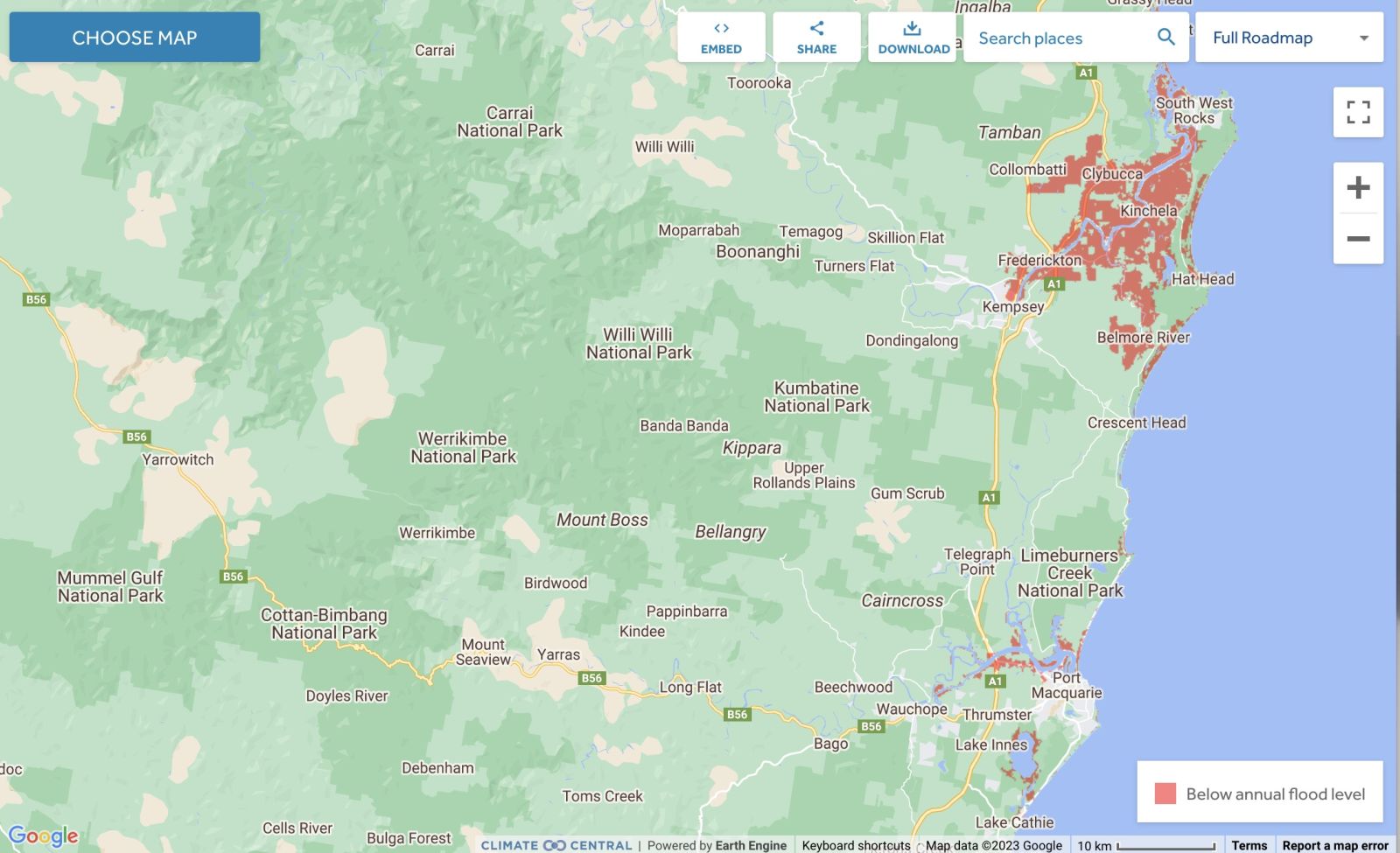
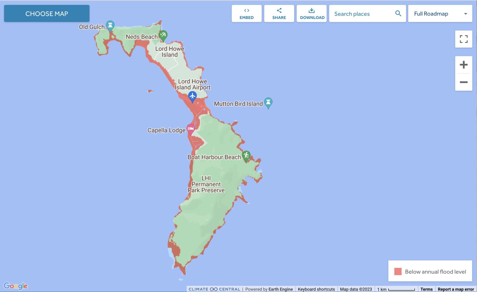
Land projected to be below annual flood level in 2050
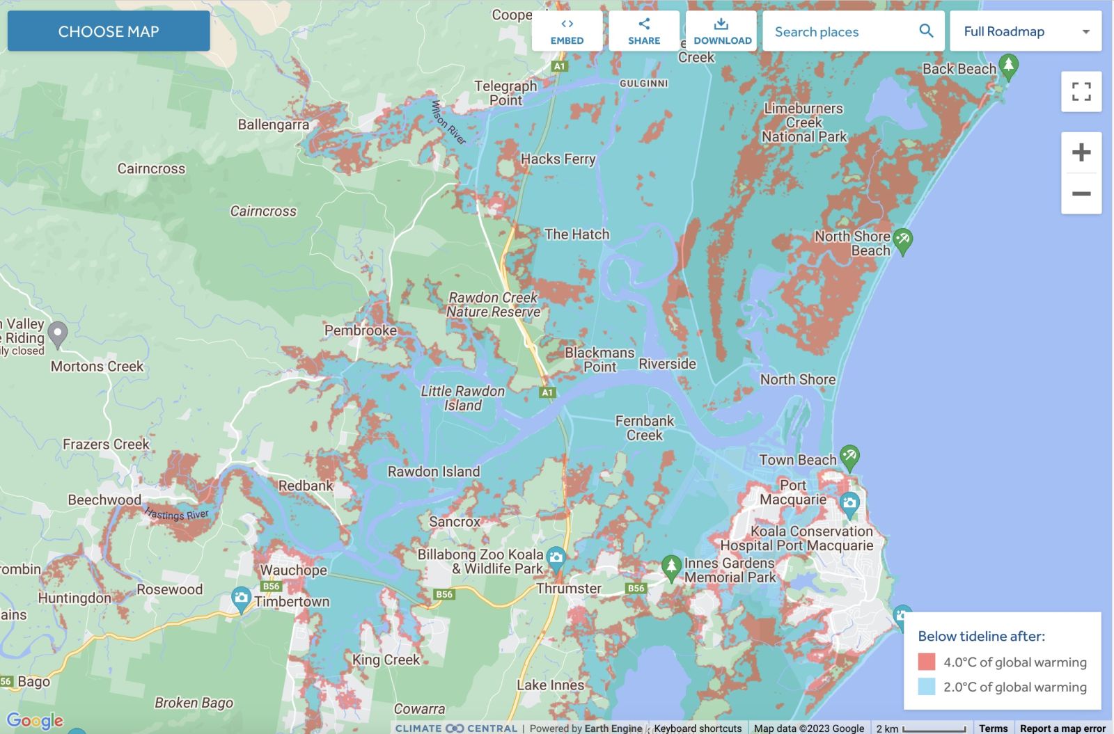
Comparison: long-term sea level outcomes
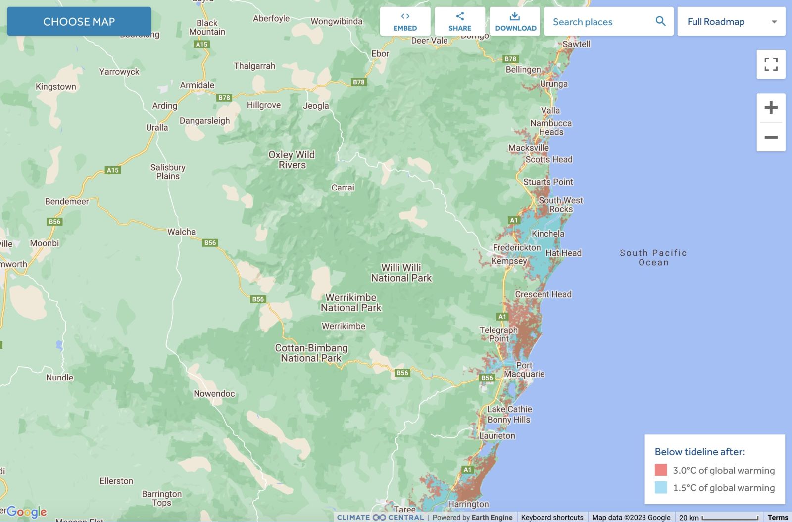
Comparison: long-term sea level outcomes
Lord Howe Island - Land projected to be below annual flood level in 2050
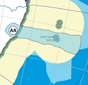
Lord Howe Island - Comparison: long-term sea level outcomes
Lord Howe Island - Comparison: long-term sea level outcomes
|
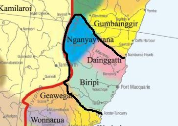
Aboriginal Australia:
|
|
|
NOTE1: Likely indicators only; for original Aboriginal Australia Map © 1991 & restrictions on its copy & use, see Aboriginal Australia Map NOTE2: The red line is part of the original Aboriginal Australia Map © 1991. The black line is added by Bloggerme for discussion only. It shows the likely State boundary based on the flow of water only. As "the ridge" (See FOWTOR) naturally impacts on the development of the language, social or nation groups of the Indigenous people of Australia, the proposed border is often identical to the group boundary shown on the Aboriginal Australia Map. This is as was expected. Variations are social/historical & result in a particular language, social or nation group being represented in two adjoining States. |
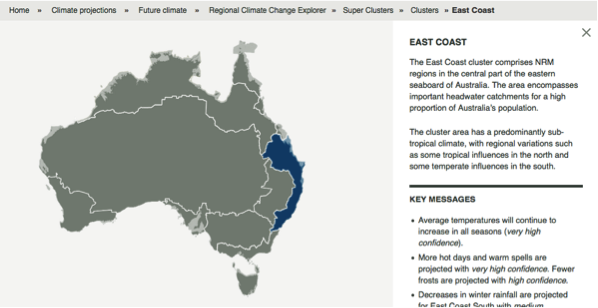 |
Other regional projections - CSIRO part of East Coast regionThe CSIRO has regions for projecting the impact of Climate Change. See https://www.climatechangeinaustralia.gov.au/en/climate-projections/futur... This state, New England State (AA), is one of the clear projections in a CSIRO cluster called "East Coast region". CSIRO's East Coast region coincides exactly with BloggerMe's Y,Z,AA,AB,AC,AE |
Nuclear weapons
Centre ground zero CGZ - Port Macquarie - 475 kilotons (431 kilotonnes)
https://nuclearsecrecy.com/nukemap/
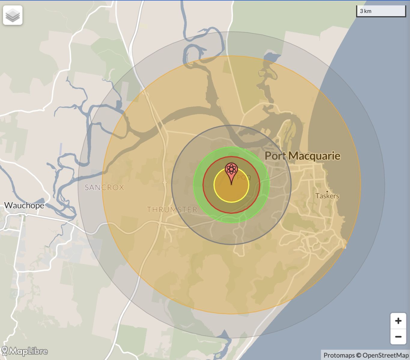
NB: population 10km around Port Macquarie CBD LEGEND
https://australia.places-in-the-world.com/2152659-place-port-macquarie.html
Population taken out by nuclear weapon = 46,791
Click here to:
Comments
Steve Irons
Thu, 08/10/2020 - 2:00pm
Permalink
Beauty
Ball's Pyramid, Lord Howe Island
https://www.pinterest.com/pin/418553359093986713/
Barrington Tops
https://www.pinterest.com/pin/418553359094273027/
Manning River
https://www.pinterest.com/pin/418553359094641471/
Lord Howe Island
https://www.pinterest.com/pin/418553359095304080/
South West Rocks. Shark Island & Mount Yarrahapinni
https://www.pinterest.com/pin/418553359095411549/
Port Macquarie beaches
https://www.pinterest.com/pin/418553359095463894/
Lord Howe Island
https://au.pinterest.com/pin/418553359101490953/
Twitter
Sun, 03/03/2013 - 2:48pm
Permalink
double jeopardy
ILC UNSW @ILC_UNSW
NSW AG knocked back formal request by Bowraville families to retry man previously acquitted under double jeopardy law http://m.smh.com.au/nsw/new-trial-ruled-out-in-bowraville-child-murders-20130208-2e3so.html …
Twitter
Tue, 26/02/2013 - 7:54pm
Permalink
Disaster - Kempsey, Nambucca & Port Macquarie Hastings
FarmOnline @FarmOnline
NSW natural disaster zone grows: ELEVEN areas stretching from Byron in the north to Kiama in the south have be... http://bit.ly/13GLcW6
Twitter
Fri, 25/01/2013 - 7:18pm
Permalink
Lord Howe Island
CSIRO @CSIROnews
This wks #EndangeredSpecies is Lord Howe Island stick insect. Beth Mantle @CSIROnews discusses http://bit.ly/Xywlca
Twitter
Sat, 29/12/2012 - 7:34am
Permalink
Mining in Macleay catchment
Meredith Stanton @CloudsCreek
Macleay catchment #pollution #mining "Hillgrove Mine set for recommission - Armidale Ind. http://www.armidaleindependent.com.au/wordpress/index.php/2012/02/hillgrove-mine-set-for-recommission/ …
Twitter
Tue, 18/12/2012 - 11:03am
Permalink
Nambucca
Meredith Stanton @CloudsCreek
MEETING OVER NAMBUCCA MINERAL EXPLORATION PERMIT : NBN News http://www.nbnnews.com.au/index.php/2012/12/13/meeting-over-nambucca-mineral-exploration-permit/ …
Twitter
Thu, 06/12/2012 - 5:05am
Permalink
Fracking
Ben Cubby @bencubby
Local people at Glenugie in northern NSW are currently blockading a proposed Metgasco #csg drilling site. #fracking
Twitter
Tue, 04/12/2012 - 4:49am
Permalink
Sharks Port McQ
Ben Cubby @bencubby
As shark attacks go, this one off NSW thankfully sounds pretty tame. http://bit.ly/XfZNZX #animals
Twitter
Mon, 26/11/2012 - 7:05am
Permalink
Farm tests
FarmOnline @FarmOnline
Fertiliser litmus test: FARMERS using fertiliser amendments and other alternative products in the hope of boosti... http://bit.ly/XRZups
Twitter
Sat, 24/11/2012 - 6:12pm
Permalink
flash flooding
NSW North Coast @FairfaxNSWnorth
RT @ArmidaleExpress: News snap: flash flooding at Herbert Pk Rd @ Burying Ground. Drivers take extreme care. #Armidale
Twitter
Sat, 24/11/2012 - 3:40pm
Permalink
freak storm
ArmidaleDumaresq LGA @ADC2350
Residual hail from freak storm on Rockvale Rd #Armidale pic.twitter.com/KQ2q0BQM
Twitter
Sat, 24/11/2012 - 3:38pm
Permalink
Flash flood Burying Ground creek
ArmidaleDumaresq LGA @ADC2350
Flash flood on Herbert Park Rd at Burying Ground creek. Road closed for at least two hours. pic.twitter.com/KXNRfeTA
Twitter
Fri, 16/11/2012 - 7:13pm
Permalink
Windsor proud of new energy mix
FarmOnline @FarmOnline
Windsor to praise hung parliament at meeting: FEDERAL Independent MP Tony Windsor says he won’t be hiding behind... http://bit.ly/ZNvLv8
Twitter
Thu, 15/11/2012 - 12:01pm
Permalink
Armidale agronomist
FarmOnline @FarmOnline
DPI job cuts ‘shortsighted’: DEPARTMENT of Primary Industries (DPI) agronomists are “shellshocked” at the decisi... http://bit.ly/ZuB5El
Twitter
Wed, 07/11/2012 - 4:37am
Permalink
Bushfires online
ArmidaleDumaresq LGA @ADC2350
Information on the brushfire situation on the Armidale-Kempsey Road is now available online. #Armidale @NSWRFS http://tiny.cc/d3tlmw
Steve Irons
Fri, 02/11/2012 - 9:39pm
Permalink
RBA Blogs - Armidale
http://myregion.gov.au/blogs/initiation
Add new comment