Thanks for checking this Region out.
This Region is prepared on the a-political concept that if you are interested in 'place' in Australia, the most important aspect that defines 'place', is the 'flow of water'. The Senate is interested in 'place'.
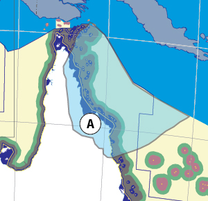
This Region defines its boundaries at the top of the ridge, where water flows one way rather than the other. This leads to a very interesting 'place'.
We are seeking a debate with people who live in this proposed new Region. We know we've got the Region pretty well correct; after all, it's just geography. But if you live in this Region you can tell us a lot of interesting things.
- Do these boundaries define a place that is unique; different to every other Region in Australia? We think that that is probably quite likely.
- Is it a great place, worthy of recognition?
- Upon formation, what should be the name of this Region? Who would be the Lord Mayor? Who would be the two Senators who represent this Region? Who would be the additional Senator that represents the interests of Aboriginal & Torres Strait Islander peoples in this region? What benefit would flow from a concept of super-Regions for the whole of the Cape York Peninsula and for the Great Barrier Reef?
- Would life be enhanced if it was on a fast Ring-Rail that links the Capital City to every other Capital City in Australia?
- Many other interesting things!
We think that this is a great new concept of regional statehood based on real concepts that define life in this particular Region. What do you think?
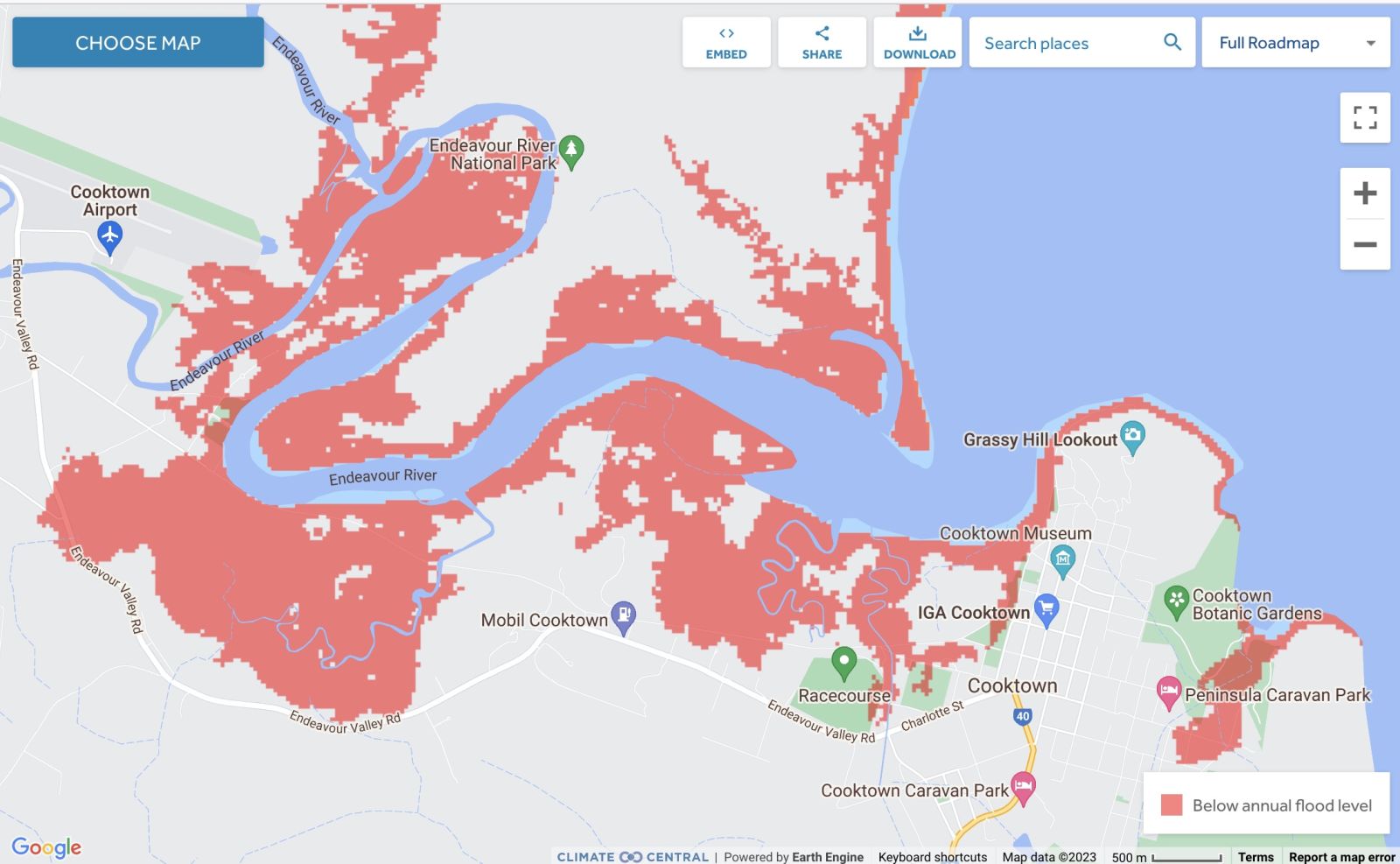
Land projected to be below annual flood level in 2050
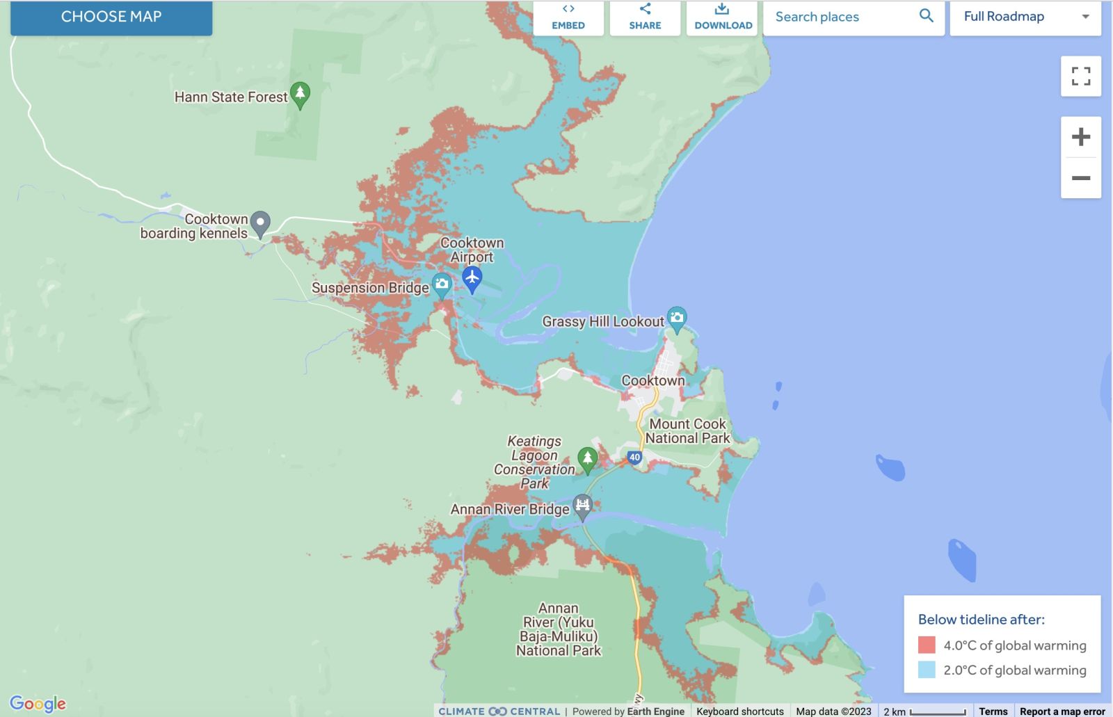
Comparison: long-term sea level outcomes
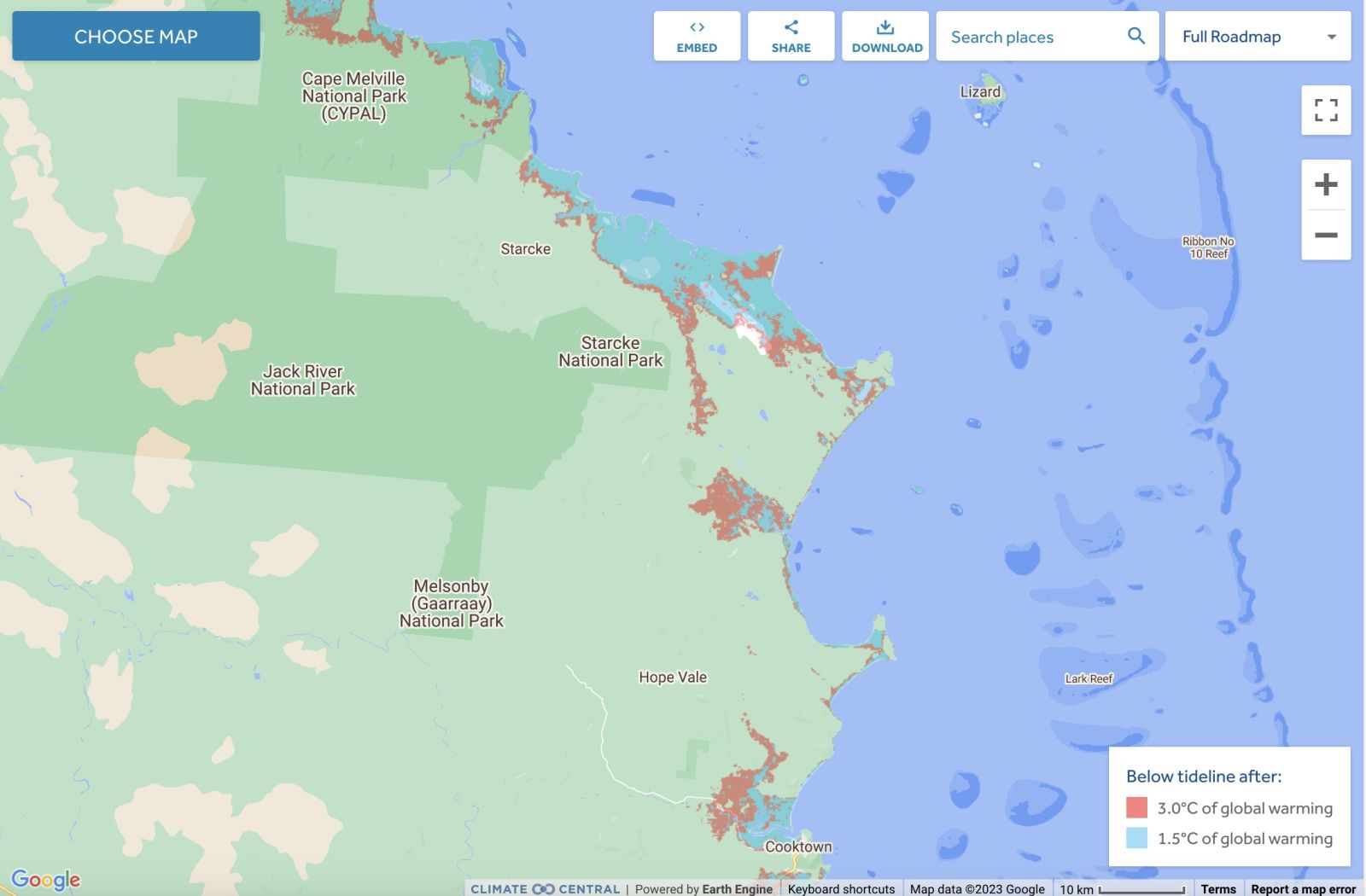
Comparison: long-term sea level outcomes
|
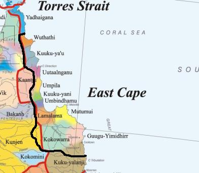
Aboriginal Australia:
|
|
|
NOTE1: Likely indicators only; for original Aboriginal Australia Map © 1991 & restrictions on its copy & use, see Aboriginal Australia Map NOTE2: The red line is part of the original Aboriginal Australia Map © 1991. The black line is added by Bloggerme for discussion only. It shows the likely State boundary based on the flow of water only. As "the ridge" (See FOWTOR) naturally impacts on the development of the language, social or nation groups of the Indigenous people of Australia, the proposed border is often identical to the group boundary shown on the Aboriginal Australia Map. This is as was expected. Variations are social/historical & result in a particular language, social or nation group being represented in two adjoining States. |
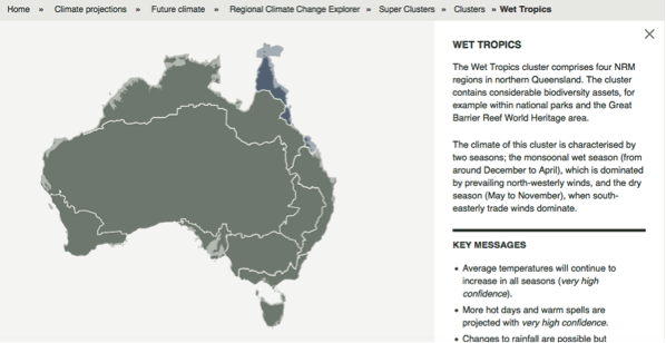
Other regional projections - CSIRO part of Wet Tropicas region
The CSIRO has regions for projecting the impact of Climate Change. See https://www.climatechangeinaustralia.gov.au/en/climate-projections/futur... This state, Carpentaria State (C), is one of the clear projections in a CSIRO cluster called "Monsoon North region". CSIRO's Wet Tropics region coincides exactly with BloggerMe's A,B,AG.
Nuclear weapons
Centre ground zero CGZ - Cooktown - 475 kilotons (431 kilotonnes)
https://nuclearsecrecy.com/nukemap/
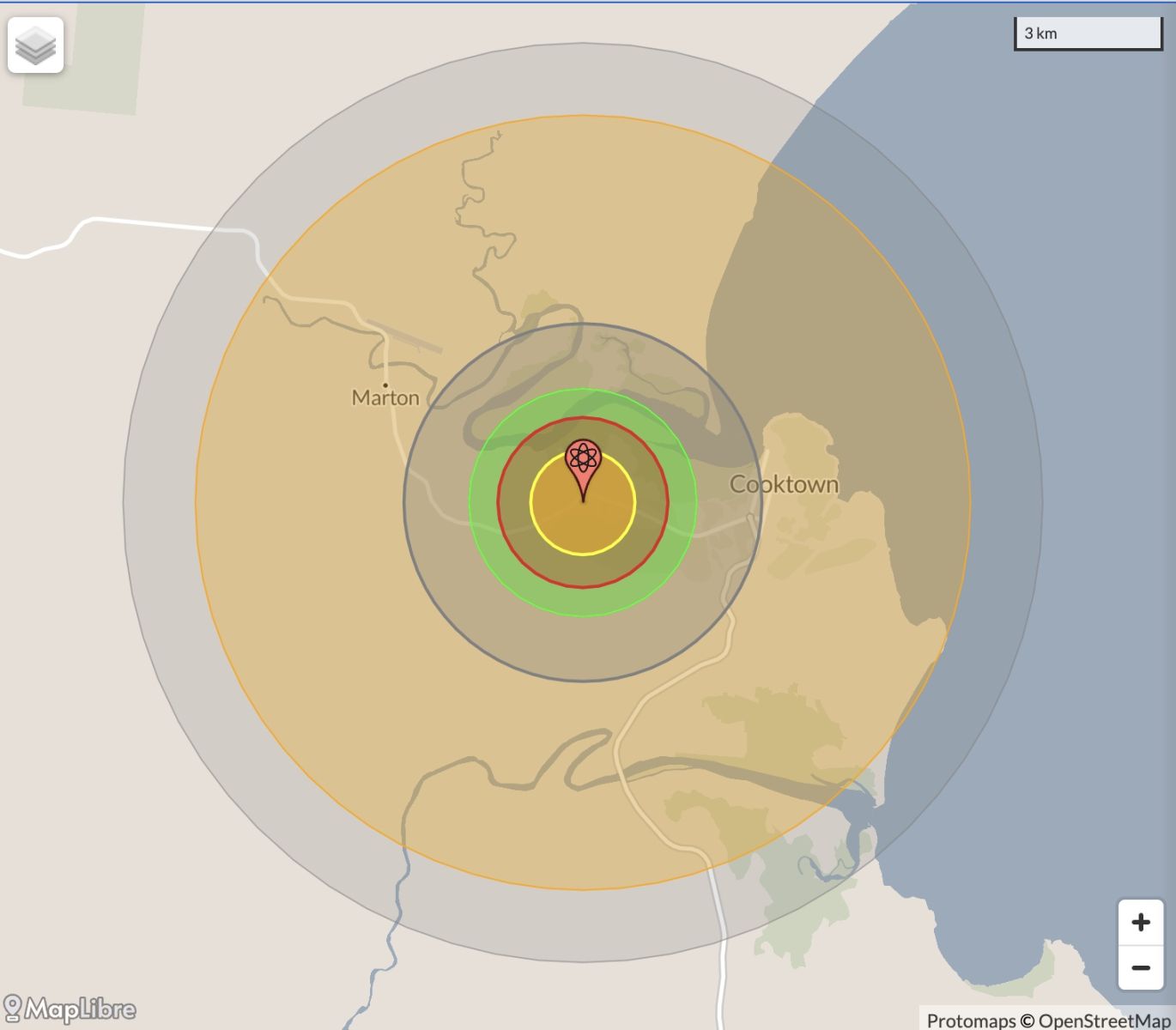
Location: https://australia.places-in-the-world.com/2170658-place-cooktown.html LEGEND
Click here to:
Comments
Steve Irons
Mon, 18/12/2023 - 1:16pm
Permalink
Steven Miles on https://twitter.com
https://twitter.com/StevenJMiles/status/1736550204357439923
Steven Miles @StevenJMiles
For more information on disaster assistance you can also visit http://qld.gov.au/disasterhelp
You can see weather updates at http://bom.gov.au and tune into ABC Radio for further updates.
10/10
https://www.qld.gov.au/community/disasters-emergencies
Find information about what to do in a natural disaster or emergency including preparation, our crisis and support hotlines, and recovery after a disaster.
11:53 am · 18 Dec 2023
Steve Irons
Mon, 18/12/2023 - 1:11pm
Permalink
Disaster recovery
Tropical Cyclone Jasper December 2023
Tropical Cyclone Jasper is affecting communities in North Queensland.
Personal hardship assistance is now available for affected residents in the Local Government Areas of:
Cairns Regional
Cassowary Coast
Cook Shire (defined localities)
Douglas Shire
Mareeba Shire
Tablelands Regional
Wujal Wujal Aboriginal Shire
Yarrabah Aboriginal Shire.
Housing assistance is available for residents affected by this event.
If you’re experiencing emotional stress or personal financial hardship from this event, contact your local emergency relief provider or counselling service or call the Community Recovery Hotline on 1800 173 349 for help.
https://www.qld.gov.au/community/disasters-emergencies
Steve Irons
Mon, 18/12/2023 - 12:54pm
Permalink
Wujal Wujal is under water - PortDouglas location
https://coastal.climatecentral.org/map/10/145.26/-16.1774/?theme=sea_lev...
Steve Irons
Mon, 18/12/2023 - 12:22pm
Permalink
BOM: Tropical cyclone Jasper
Tropical Cyclone Watch issued for northern Queensland
10/12/2023
Issued 7pm AEST Sunday 10 December 2023
A Tropical Cyclone Watch has been issued for areas between Cape Melville to Townsville, including Cairns and Cooktown.
As of 4 pm AEST today, Tropical Cyclone Jasper remains a category 2 and is situated 880 km east of Port Douglas and 850 km east of Cairns.
The system is moving in a general westwards direction at 14 kilometres per hour. Jasper is forecast to maintain intensity during Monday and Tuesday.
Jasper is forecast to intensify to a category 3 cyclone shortly before making landfall on Wednesday, most likely between Cooktown and Cardwell.
Damaging winds are expected to develop along the Queensland coast between Cooktown and Ingham, including Cairns from Tuesday and may extend as far south as Townsville or as far north as Cape Melville depending on Jasper's movement.
Heavy rainfall is expected to develop along the coast from late Tuesday.
As the cyclone approaches the coast, abnormally high tides are possible and large waves are likely along the coast.
Communities in these areas are advised to review their cyclone plan.
For cyclone preparedness and safety advice, check with your local council or emergency services.
The next Information Bulletin will be issued by 11pm AEST.
For the latest Tropical Cyclone advice and track maps, visit: http://www.bom.gov.au/cyclone/
For Tropical Cyclone Outlooks, visit: http://www.bom.gov.au/cyclone/outlooks/index.shtml
Know your weather. Know your risk. Communities should stay up to date with the latest forecasts and warnings via our website and BOM Weather app and follow advice of emergency services.
ENDS
Steve Irons
Fri, 02/10/2020 - 5:43pm
Permalink
Beauty
Port Douglas, Boat ramp
https://www.pinterest.com/pin/418553359095096207/
Port Douglas, beach closed TCNathan
https://www.pinterest.com/pin/418553359095096322/
Cooktown; the calm before the storm
https://www.pinterest.com/pin/418553359095097716/
Steve Irons
Fri, 20/03/2015 - 3:21pm
Permalink
TCNathan comes in above Cape Flattery still at Category 3
@ABCFarNorth 3h3 hours ago
#TCNathan still remains as a category 3 cyclone and moves west-northwest at 16km/h http://www.bom.gov.au/cgi-bin/wrap_fwo.pl?IDQ20032.html …
Steve Irons
Fri, 20/03/2015 - 2:06am
Permalink
TCNathan on the way back towards Cape Flattery
@ABCemergency 19 Mar 2015 10:05PM
#TCNathan estimated to be 80km ENE of Cape Flattery & 115km NE of Cooktown http://ab.co/1wnMHg5
Steve Irons
Fri, 20/03/2015 - 1:50am
Permalink
TCNathan on the way back towards Cooktown2
WORLD OUTBACK NEWS @WON_Live · Mar 18
#CycloneNathan is cat 3 & intensifying, estimated to be 405km of #Cooktown, #Queensland. http://ab.co/1wnMHg5 #QLD
Steve Irons
Thu, 19/03/2015 - 12:18am
Permalink
TC Nathan going to Category 4 as it heads to shore
TC Nathan going to Category 4 as it heads to shore Cape Flattery
http://www.bom.gov.au/products/IDQ65002.shtml
Steve Irons
Tue, 17/03/2015 - 6:54pm
Permalink
TCNathan on the way back towards Cooktown
http://www.bom.gov.au/products/IDQ65002.shtml
@jennyweather And the latest track map. Seems likley it will then cross into Gulf waters.
Steve Irons
Mon, 16/03/2015 - 9:27pm
Permalink
TCNathan playing around
Pulled back out to sea, by TCPam
Now heading back to Cairns
Steve Irons
Fri, 13/03/2015 - 12:50pm
Permalink
TC Nathan heading back out to sea
Part of a multiple cyclone system, TCNathan is pulled out to sea as TCPam strengthens in Vanuatu and TCOlwyn hits land at Exmouth.
https://twitter.com/ABCemergency/status/576187946753101826/photo/1
http://www.abc.net.au/news/emergency/
http://www.bom.gov.au/cyclone/about/warnings/
Steve Irons
Wed, 11/03/2015 - 2:07pm
Permalink
Cyclone Nathan heading for Cape Flattery
@ABCemergency
A cyclone part of a multiple cyclone system including Cyclone Nathan heading towards Cape Flattery & Cooktown & Cyclone Pam over Vanuatu. @ABCemergency 3m3 minutes ago pic.twitter.com/BkFpyocUQP
https://www.facebook.com/ABCweatherandemergency/posts/403916269789143
Cyclone warnings for #Qld (Coen - Cape Trib) + #WA (inc Karatha + Exmouth). #CycloneNathan
http://www.abc.net.au/news/emergency/
Steve Irons
Sat, 12/04/2014 - 12:45pm
Permalink
Tropical Cyclone Ita -Land , Cape Flattery, Cooktown 4TO1
http://www.bom.gov.au/products/IDQ65002.shtml
Steve Irons
Fri, 11/04/2014 - 9:25pm
Permalink
Severe Tropical Cyclone Ita - Land @ Cape Flattery to Cooktown
http://www.bom.gov.au/products/IDQ65002.shtml
Steve Irons
Fri, 11/04/2014 - 12:20pm
Permalink
Severe Tropical Cyclone Ita - Cooktown Land within 24 hours
http://www.bom.gov.au/products/IDQ65002.shtml
Steve Irons
Thu, 10/04/2014 - 4:14pm
Permalink
Severe Tropical Cyclone Ita - Cape Flattery, Cooktown, Laura
http://www.bom.gov.au/products/IDQ65002.shtml
Steve Irons
Wed, 09/04/2014 - 10:25am
Permalink
Severe Tropical Cyclone Ita - Gales within 24 hours
http://www.bom.gov.au/products/IDQ65002.shtml
Steve Irons
Tue, 08/04/2014 - 12:30pm
Permalink
Tropical Cyclone Ita - Now Cape Melville?
http://www.bom.gov.au/products/IDQ65002.shtml
Steve Irons
Mon, 07/04/2014 - 3:29pm
Permalink
Tropical Cyclone Ita - Lockhart River?
http://www.bom.gov.au/products/IDQ65002.shtml
Steve Irons
Sun, 06/04/2014 - 9:25pm
Permalink
Tropical Cyclone Ita
http://www.bom.gov.au/products/IDQ65002.shtml
Steve Irons
Sat, 23/11/2013 - 7:39pm
Permalink
Cape York
http://www.cylc.org.au/files/6513/6125/1442/NTRB_Boundary_Map.jpg
Steve Irons
Sat, 23/11/2013 - 7:37pm
Permalink
CYLC
http://www.cylc.org.au/
Conversation
Fri, 10/05/2013 - 8:43pm
Permalink
Dugongs are safer in Torres Strait
"The status of Australian dugongs varies greatly. Shark Bay supports a large dugong population with minimal human pressures, making it the most secure dugong population in the world. On the other hand, the urban coast of the Great Barrier Reef (GBR) region between Cairns and Bundaberg poses many threats to dugongs.
"Torres Strait is the world’s largest dugong habitat. Surveys conducted by my group at James Cook University show that the region contains a remarkable 58% of the habitat supporting high densities of dugongs in Queensland, as illustrated by the map below."
"Dugong habitat in Torres Strait is much more extensive than we thought. In 2010, the Torres Strait Regional Authority partnered with scientists at Fisheries Queensland to conduct the first seagrass survey of far western Torres Strait. This survey discovered that this very remote region supported the largest continuous seagrass bed in Australia. My group subsequently extended our aerial survey of Torres Strait to cover this area and established that it also supports a sizable dugong population."
Helene Marsh Distinguished Professor of Environmental Science at James Cook University: "Dugongs are safer in Torres Strait than Townsville" in The Conversation 10 May 2013, 6.31am EST
Read more: https://theconversation.com/dugongs-are-safer-in-torres-strait-than-town...
Twitter
Sat, 09/03/2013 - 12:46am
Permalink
Indigenous performers on radio
ABC Far North QLD @ABCFarNorth
#FNQ's emerging Indigenous performers are coming 2 the radio + we want you 2 #ListenUp! http://tinyurl.com/a63o9zy
Twitter
Fri, 08/03/2013 - 3:08pm
Permalink
Hopevale
ABC Far North QLD @ABCFarNorth
Shots allegedly fired as hundreds riot in #Aurukun http://www.abc.net.au/news/2013-03-06/shots-allegedly-fired-as-hundreds-riot-in-aurukun/4555310 …
Twitter
Mon, 14/01/2013 - 2:18am
Permalink
Wet season
ABC Far North QLD @ABCFarNorth
Cook Shire Mayor Peter Scott: "Teams working hard to fix major power failure - EMQ, Ergon well rehearsed for this being wet season."
Twitter
Tue, 18/12/2012 - 10:56am
Permalink
Diuron
Meredith Stanton @CloudsCreek
Ban Lethal Herbicide Near Great Barrier Reef http://www.thepetitionsite.com/411/584/102/ban-lethal-herbicide-near-great-barrier-reef/#bbtw=450903454 …
Twitter
Thu, 06/12/2012 - 2:13am
Permalink
Great Barrier Reef
FarmOnline @FarmOnline
Bid to save green tape: A GROUP of Australia's most respected scientists is urging the federal government to aba... http://bit.ly/11Jd7Wb
Twitter
Tue, 04/12/2012 - 1:28am
Permalink
Couple found
ABC Far North QLD @ABCFarNorth
Couple missing on Cape York found safe http://bit.ly/11Cs5xk
Twitter
Thu, 29/11/2012 - 4:32am
Permalink
Murder case
ABC Far North QLD @ABCFarNorth
Bail for cattle station couple accused of murder http://bit.ly/10LuC8L
Twitter
Tue, 20/11/2012 - 3:58am
Permalink
Cruise
cooktown cape york @mycooktown
Shrek goes to sea http://www.smh.com.au/travel/shrek-goes-to-sea-20121116-29ggx.html … v
Twitter
Wed, 14/11/2012 - 1:22pm
Permalink
Eclypse - Palmer River
ABC Far North QLD @ABCFarNorth
It's been 10 minutes since totality at the #solareclipse2012 #PalmerRiver - I still have goosebumps! pic.twitter.com/JkTmnSAM
Twitter
Tue, 13/11/2012 - 4:50am
Permalink
Palmer River
ABC Far North QLD @ABCFarNorth
ABC Far North's Phil Staley is in Palmer River and says two portable hospitals have been set up there. The... http://fb.me/1WArQo4OE
Twitter
Tue, 13/11/2012 - 4:48am
Permalink
eclipse
ABC Far North QLD @ABCFarNorth
Time to edit sone interviews at #PalmerRiver ahead of #eclipse2012 - uh oh, @farnorthfiona is buggered. pic.twitter.com/B3oJGVsH
Twitter
Tue, 13/11/2012 - 4:47am
Permalink
eclipse
ABC Far North QLD @ABCFarNorth
Daytime dance floor at #eclipse2012 festival - some ABC staff may/may not have danced. pic.twitter.com/wDA3A6O1
Twitter
Tue, 13/11/2012 - 4:46am
Permalink
eclipse
ABC Far North QLD @ABCFarNorth
Luke and Matt from Burleigh are giving free music lessons at the #eclipse2012 festival! Learn the bongo! #PalmerRiver pic.twitter.com/6XulC67m
Twitter
Tue, 13/11/2012 - 4:45am
Permalink
eclipse
ABC Far North QLD @ABCFarNorth
10,000 party lovers at #PalmerRiver for the #eclipse2012 festival. Like a village in the middle of nowhere! pic.twitter.com/7WuFRX4C
Twitter
Tue, 13/11/2012 - 4:27am
Permalink
Eclypse
ABC Far North QLD @ABCFarNorth
Amazing! 6000 campers at #PalmerRiver for the #eclipse2012 Palmer has become the centre of the universe! pic.twitter.com/k1cfTAsc
Twitter
Mon, 12/11/2012 - 7:44am
Permalink
Cultural significance
ILC UNSW @ILC_UNSW
THE Wet Tropics has been recognised by Federal govt for its indigenous cultural significance to Australia. http://www.cairns.com.au/article/2012/11/09/236218_local-news.html …
Twitter
Fri, 09/11/2012 - 1:16pm
Permalink
Cape York UNESCO bid
ABC Far North QLD @ABCFarNorth
'Unanswered questions' over Cape's UNESCO bid http://bit.ly/RIgeKY
Twitter
Fri, 09/11/2012 - 1:09pm
Permalink
Coral is under threat
ABC Far North QLD @ABCFarNorth
Saudi, Australian experts unite to save coral http://bit.ly/TwdOLA
Twitter
Thu, 08/11/2012 - 2:46am
Permalink
Lockhart River crash
ILC UNSW @ILC_UNSW
Kate Galloway on why Lockhart River crash compensation a big win for Indigenous justice http://theconversation.edu.au/lockhart-river-crash-compensation-a-big-win-for-indigenous-justice-10257 …
Twitter
Thu, 08/11/2012 - 2:46am
Permalink
Lockhart River plane crash
ILC UNSW @ILC_UNSW
Justice Henry QLD Sup Crt handed down judgement in favour of families of five killed in 2005 Lockhart River plane crash http://www.austlii.edu.au/au/cases/qld/QSC/2012/311.html …
Steve Irons
Sun, 14/10/2012 - 3:09am
Permalink
Rough draft - Great Barrier Reef
http://bloggerme.com.au/super-state-1-great-barrier-reef
07/11/2012 - 3:46pm Lockhart River plane crash http://www.austlii.edu.au/au/cases/qld/QSC/2012/311.html …
Add new comment