Thanks for checking this Sub-region out.
This Sub-region is prepared on the a-political concept that if you are interested in 'place' in Australia, the most important aspect that defines 'place', is the 'flow of water'. The Senate is interested in 'place'.
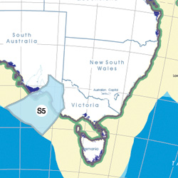
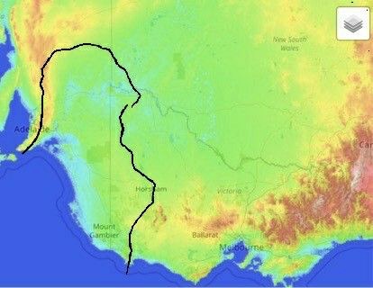
This Sub-region defines its boundaries at the top of the ridge, where water flows one way rather than the other. This leads to a very interesting 'place'.
We are seeking a debate with people who live in this proposed new Sub-region. We know we've got the Sub-region pretty well correct; after all, it's just geography. But if you live in this Region you can tell us a lot of interesting things.
- Do these boundaries define a place that is unique; different to every other Region in Australia? We think that that is probably quite likely.
- Is it a great place, worthy of recognition?
- Would life be enhanced if it was on a fast Ring-Rail that links the Capital Cities in the Sub-region to capital cities around Australia?
|
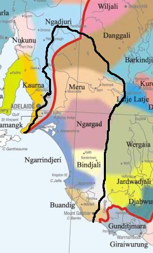
Aboriginal Australia:
|
|
|
NOTE1: Likely indicators only; for original Aboriginal Australia Map © 1991 & restrictions on its copy & use, see Aboriginal Australia Map NOTE2: The red line is part of the original Aboriginal Australia Map © 1991. The black line is added by Bloggerme for discussion only. It shows the likely State boundary based on the flow of water only. As "the ridge" (See FOWTOR) naturally impacts on the development of the language, social or nation groups of the Indigenous people of Australia, the proposed border is often identical to the group boundary shown on the Aboriginal Australia Map. This is as was expected. Variations are social/historical & result in a particular language, social or nation group being represented in two adjoining States. |
https://www.pinterest.com.au/pin/418553359123622034/
.jpg)
https://www.pinterest.com.au/pin/418553359123643739/
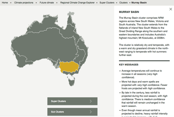
The CSIRO has regions for projecting the impact of Climate Change. See https://www.climatechangeinaustralia.gov.au/en/climate-projections/futur... This sub-state, Murray-Darling Basin Foreshore Sub-State (S5), is one of the clear projections in a CSIRO cluster called "Murray Basin region". CSIRO's Murray Basin region coincides with BloggerMe's S2,S3,S4,S5.
Nuclear weapons
Centre ground zero CGZ - Murray Bridge - 475 kilotons (431 kilotonnes)
https://nuclearsecrecy.com/nukemap/
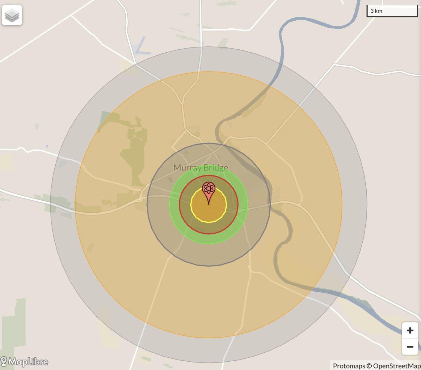
NB: population 10km around Murray Bridge CBD LEGEND
https://australia.places-in-the-world.com/2065176-places-within-10km-aro...
Population taken out by nuclear weapon = 1,882
Click here to:
Comments
Steve Irons
Thu, 01/10/2020 - 2:45pm
Permalink
Beauty
Seal Bay, Kangaroo Island
https://www.pinterest.com/pin/418553359094156075/
Vivonne Bay beach & Seal Bay, Kangaroo Island
https://www.pinterest.com/pin/418553359094156132/
Tunkalilla Beach, Tunkalilla
https://www.pinterest.com/pin/418553359093990135/
Adelaide Plains
https://www.pinterest.com/pin/418553359094238663/
Peterborough, Stone home
https://www.pinterest.com/pin/418553359094635894/
Wine growing, Longview Vineyard, Adelaide Hills
https://www.pinterest.com/pin/418553359094698284/
Murray Princess, paddlewheeler on the Murray
https://www.pinterest.com/pin/418553359094970059/
Clare Valley, historical dwellings & vineyards
https://www.pinterest.com/pin/418553359094970070/
Murray River, downstream
https://www.pinterest.com/pin/418553359095042861/
Bushland around Deep Creek Conservation Park, Fleurieu peninsula
https://www.pinterest.com/pin/418553359095043522/
Sunset, Glenelg north beach, Adelaide south
https://www.pinterest.com/pin/418553359095102926/
Murray River Princess paddle steamer, Mannum
https://www.pinterest.com/pin/418553359095477533/
The Murray Princess, Mannum
https://www.pinterest.com/pin/418553359095477530/
Murray River, Murray Darling Basin Foreshore
https://www.pinterest.com/pin/418553359095480395/
Vineyards, Barossa Valley
https://www.pinterest.com/pin/418553359095477519/
Barossa reds, Barossa Valley
https://www.pinterest.com/pin/418553359095501375/
Barossa Valley, autumn
https://www.pinterest.com/pin/418553359095501482/
Adelaide Oval
https://www.pinterest.com/pin/418553359095759246/
Morialta Caves, Adelaide Hills
https://www.pinterest.com/pin/418553359095832976/
Barossa Valley
https://www.pinterest.com/pin/418553359098539439/
Brighton Beach, Adelaide City
https://au.pinterest.com/pin/418553359099391056/
Conversation
Sat, 06/04/2013 - 3:13am
Permalink
The plight of Australia’s threatened freshwater mussels
"Already, mussels have disappeared from many streams in eastern Australia from loss of catchment vegetation in association with agricultural development. The habitats in many streams have become degraded from channel erosion and sedimentation. Increased nutrient loads in runoff, loss of shading vegetation and invasive water plants like Salvinia molesta and water hyacinth (Eichhornia spp.) have badly affected mussels in some parts of Australia.
"Efforts have been made to bring the plight of the freshwater mussel to the attention of conservation bodies. Species such as the Glenelg River Mussel (Hyridella glenelgensis) have been recently listed as “Critically Endangered” under the Victorian Flora and Fauna Guarantee Act 1988 and the Commonwealth Environment Protection and Biodiversity Conservation Act 1999 (EPBC Act)."
Michael Klunzinger Dr - Honorary Research Associate - School of Veterinary and Life Sciences at Murdoch University: The Conversation 4 April 2013, 2.24pm AEST
Read more: https://theconversation.com/in-muddy-waters-the-plight-of-australias-thr...
Twitter
Sat, 12/01/2013 - 5:14am
Permalink
Remains
ILC UNSW @ILC_UNSW
Aboriginal groups have been left distraught by the discovery of Indigenous remains during work to duplicate the Southern Expressway
Twitter
Sat, 12/01/2013 - 5:04am
Permalink
Merino industry
FarmOnline @FarmOnline
Merino industry farewells Ron Collins: MERINO stalwart Ron Collins – one of the most highly respected Merino ind... http://bit.ly/ZM7fNM
Twitter
Sat, 29/12/2012 - 5:21pm
Permalink
Wellington
Simon Birmingham @Birmo
the three windmills by the ferry crossing of the Murray at Wellington in SA ... http://twitpic.com/bqcysc
Twitter
Sat, 29/12/2012 - 5:20pm
Permalink
Wellington
Simon Birmingham @Birmo
some driftwood & waters of the Murray at wonderful Wellington in SA ... http://twitpic.com/bqcy1p
Twitter
Tue, 18/12/2012 - 10:37am
Permalink
Penguins in decline
Ben Cubby @bencubby
Penguins on Kangaroo Island are either not filling out their census forms, or in decline. http://bit.ly/UV7qm6
Twitter
Wed, 12/12/2012 - 4:08am
Permalink
River mouth
FarmOnline @FarmOnline
Locks, stock and barrages: FEDERAL Water Minister Tony Burke wants 2750 gigalitres of fresh water flushed down t... http://bit.ly/VN3KBz
Twiitter
Wed, 12/12/2012 - 3:49am
Permalink
Murray-Darling basin
FarmOnline @FarmOnline
Muddied Waters documentary screens Sunday: MAKERS of a community-funded documentary about the Murray-Darling Bas... http://bit.ly/YGTMaq
Twitter
Sat, 03/11/2012 - 4:32pm
Permalink
Hindmarsh Island controversy
Matthew Rimmer @DrRimmer
Kathy Bowrey from UNSW analysed the Hindmarsh Island controversy in terms of IP and cultural heritage.
Steve Irons
Fri, 02/11/2012 - 10:37pm
Permalink
RDA Blogs - Kangaroo Island
http://myregion.gov.au/blogs/light-bulb-moments
Steve Irons
Fri, 02/11/2012 - 9:00pm
Permalink
RDA Blogs - Barossa Valley
http://myregion.gov.au/blogs/good-year-last-barossa-wine-producers
Steve Irons
Fri, 02/11/2012 - 8:41pm
Permalink
RDA Blogs - Limestone Coast
http://myregion.gov.au/blogs/strengthening-communities-through-career-de...
Steve Irons
Fri, 02/11/2012 - 7:34pm
Permalink
RDA Blogs - Renmark
http://myregion.gov.au/blogs/riverland%E2%80%99s-young-aboriginal-women-...
Add new comment