Thanks for checking this Region out.
This Region is prepared on the a-political concept that if you are interested in 'place' in Australia, the most important aspect that defines 'place', is the 'flow of water'. The Senate is interested in 'place'.
This Region defines its boundaries at the top of the ridge, where water flows one way rather than the other. This leads to a very interesting 'place'.
We are seeking a debate with people who live in this proposed new Region. We know we've got the Region pretty well correct; after all, it's just geography. But if you live in this Region you can tell us a lot of interesting things.
- Do these boundaries define a place that is unique; different to every other Region in Australia? We think that that is probably quite likely.
- Is it a great place, worthy of recognition?
- Upon formation, what should be the name of this Region? Who would be the Lord Mayor? Who would be the two Senators who represent this Region? Who would be the additional Senator that represents the interests of Aboriginal & Torres Strait Islander peoples in this region? What benefit would flow from a concept of super-Regions for the whole of the Great Barrier Reef?
- Would life be enhanced if it was on a fast Ring-Rail that links the Capital City to every other Capital City in Australia?
- Many other interesting things!
We think that this is a great new concept of regional statehood based on real concepts that define life in this particular Region. What do you think?
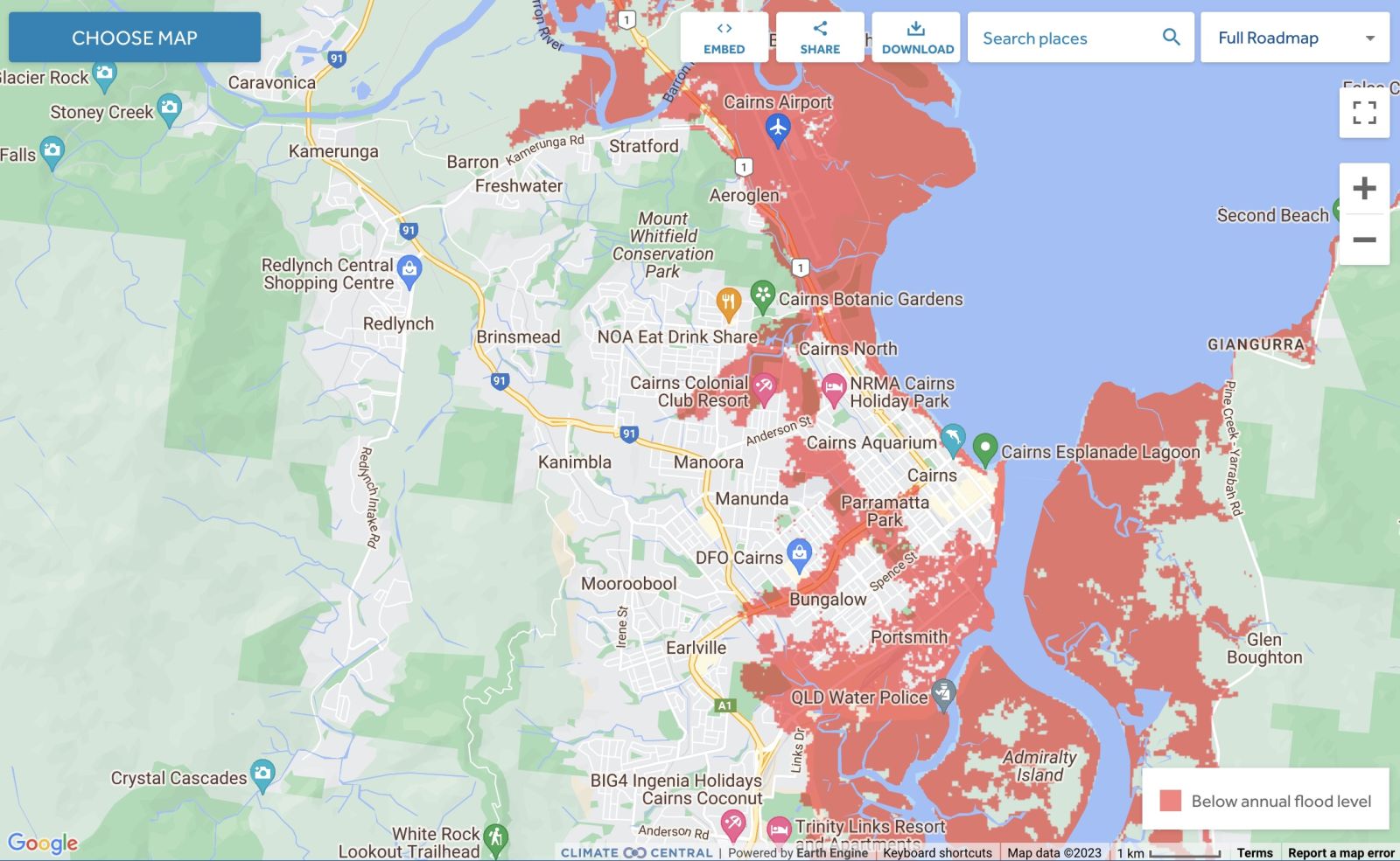
Land projected to be below annual flood level in 2050
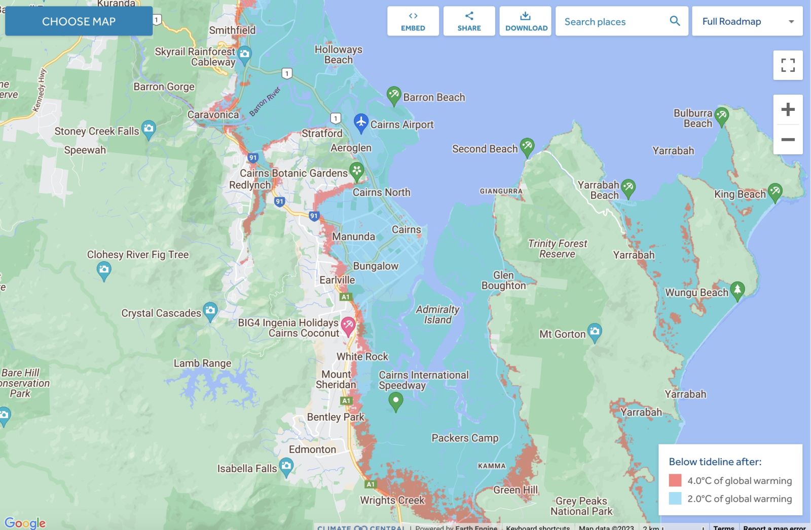
Comparison: long-term sea level outcomes
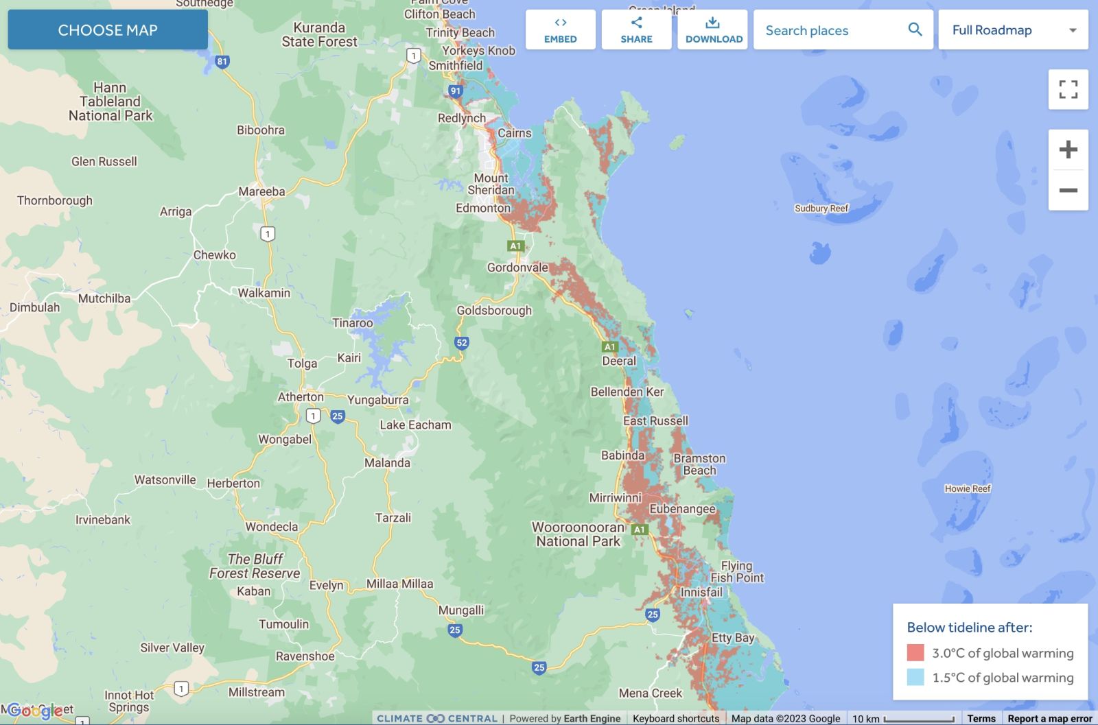
Comparison: long-term sea level outcomes
|
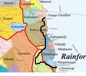
Aboriginal Australia:
|
|
|
NOTE1: Likely indicators only; for original Aboriginal Australia Map © 1991 & restrictions on its copy & use, see Aboriginal Australia Map NOTE2: The red line is part of the original Aboriginal Australia Map © 1991. The black line is added by Bloggerme for discussion only. It shows the likely State boundary based on the flow of water only. As "the ridge" (See FOWTOR) naturally impacts on the development of the language, social or nation groups of the Indigenous people of Australia, the proposed border is often identical to the group boundary shown on the Aboriginal Australia Map. This is as was expected. Variations are social/historical & result in a particular language, social or nation group being represented in two adjoining States. |
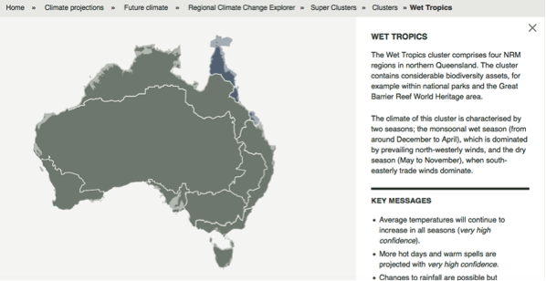
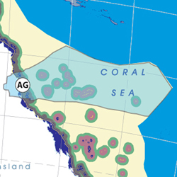
Other regional projections - CSIRO part of Wet Tropics region
The CSIRO has regions for projecting the impact of Climate Change. See https://www.climatechangeinaustralia.gov.au/en/climate-projections/futur... This state, Carpentaria State (C), is one of the clear projections in a CSIRO cluster called "Monsoon North region". CSIRO's Wet Tropics region coincides exactly with BloggerMe's A,B,AG.
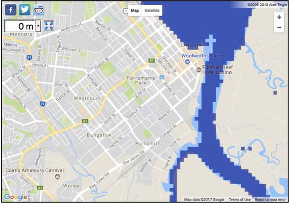
Cairns - current sea level 2017
The current sea level 2017 needs to be understood in the context of rising sea levels. See below:
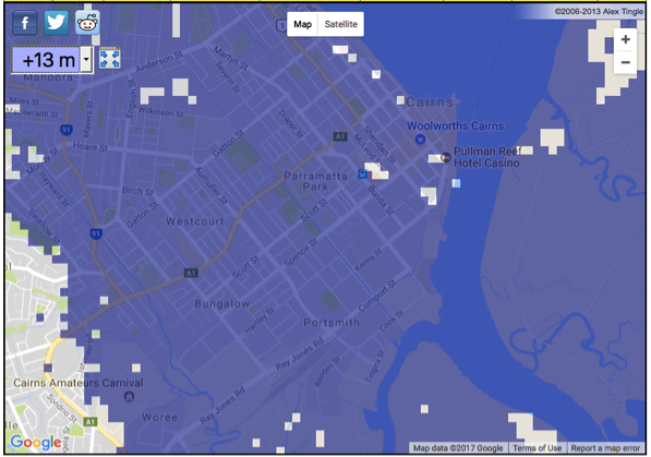
Cairns - impact of 13m sea level rise - 20??
A recent scientific impact test by US scientists in the Antarctica suggests that the global warming at present happening across the world will cause a crash of glacial caps in the Antarctica will transform an expected 13 ft (4 metres) sea level rise to a 13 metres sea level rise arising from Antarctica alone. When this happens, Cairns will be taken out.
Read more:
http://www.rollingstone.com/politics/features/the-doomsday-glacier-w481260
https://www.theverge.com/2017/9/26/16363158/antarctica-glaciers-melting-...
To do your own calculations, try here: http://geology.com/sea-level-rise/
Nuclear weapons
Centre ground zero CGZ - Cairns - 475 kilotons (431 kilotonnes)
https://nuclearsecrecy.com/nukemap/
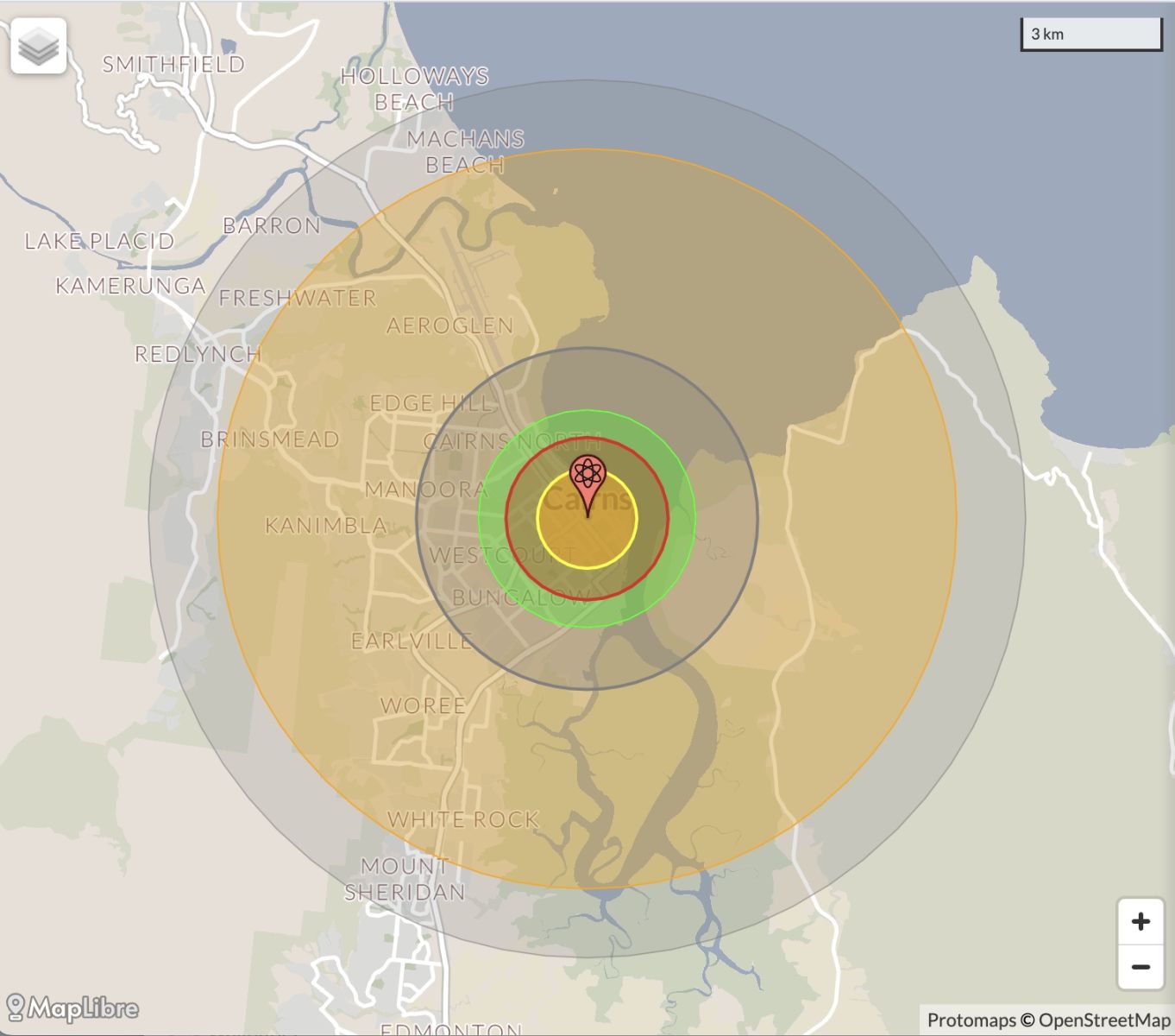
NB: population 10km around Cairns CBD LEGEND
https://australia.places-in-the-world.com/11703914-places-within-10km-ar...
Population taken out by nuclear weapon = 95,791
Click here to:
Comments
Steve Irons
Mon, 18/12/2023 - 1:43pm
Permalink
Cassowary Coast is under water - Cairns location
https://coastal.climatecentral.org/map/9/145.5368/-17.518/?theme=sea_lev...
Steve Irons
Mon, 18/12/2023 - 1:30pm
Permalink
Yarrabah is under water - Cairns location
https://coastal.climatecentral.org/map/11/145.9011/-17.0174/?theme=sea_l...
Steve Irons
Mon, 18/12/2023 - 12:19pm
Permalink
BOM: Tropical cyclone Jasper
Tropical Cyclone Watch issued for northern Queensland
10/12/2023
Issued 7pm AEST Sunday 10 December 2023
A Tropical Cyclone Watch has been issued for areas between Cape Melville to Townsville, including Cairns and Cooktown.
As of 4 pm AEST today, Tropical Cyclone Jasper remains a category 2 and is situated 880 km east of Port Douglas and 850 km east of Cairns.
The system is moving in a general westwards direction at 14 kilometres per hour. Jasper is forecast to maintain intensity during Monday and Tuesday.
Jasper is forecast to intensify to a category 3 cyclone shortly before making landfall on Wednesday, most likely between Cooktown and Cardwell.
Damaging winds are expected to develop along the Queensland coast between Cooktown and Ingham, including Cairns from Tuesday and may extend as far south as Townsville or as far north as Cape Melville depending on Jasper's movement.
Heavy rainfall is expected to develop along the coast from late Tuesday.
As the cyclone approaches the coast, abnormally high tides are possible and large waves are likely along the coast.
Communities in these areas are advised to review their cyclone plan.
For cyclone preparedness and safety advice, check with your local council or emergency services.
The next Information Bulletin will be issued by 11pm AEST.
For the latest Tropical Cyclone advice and track maps, visit: http://www.bom.gov.au/cyclone/
For Tropical Cyclone Outlooks, visit: http://www.bom.gov.au/cyclone/outlooks/index.shtml
Know your weather. Know your risk. Communities should stay up to date with the latest forecasts and warnings via our website and BOM Weather app and follow advice of emergency services.
ENDS
Steve Irons
Mon, 18/12/2023 - 12:08pm
Permalink
Steven Miles on https://twitter.com
https://twitter.com/StevenJMiles/status/1736550204357439923
Steven Miles @StevenJMiles
For more information on disaster assistance you can also visit http://qld.gov.au/disasterhelp
You can see weather updates at http://bom.gov.au and tune into ABC Radio for further updates.
10/10
https://www.qld.gov.au/community/disasters-emergencies
Find information about what to do in a natural disaster or emergency including preparation, our crisis and support hotlines, and recovery after a disaster.
11:53 am · 18 Dec 2023
Steve Irons
Mon, 18/12/2023 - 12:04pm
Permalink
Disaster recovery
Tropical Cyclone Jasper December 2023
Tropical Cyclone Jasper is affecting communities in North Queensland.
Personal hardship assistance is now available for affected residents in the Local Government Areas of:
Cairns Regional
Cassowary Coast
Cook Shire (defined localities)
Douglas Shire
Mareeba Shire
Tablelands Regional
Wujal Wujal Aboriginal Shire
Yarrabah Aboriginal Shire.
Housing assistance is available for residents affected by this event.
If you’re experiencing emotional stress or personal financial hardship from this event, contact your local emergency relief provider or counselling service or call the Community Recovery Hotline on 1800 173 349 for help.
https://www.qld.gov.au/community/disasters-emergencies
Steve Irons
Tue, 06/10/2020 - 5:20pm
Permalink
Beauty
Atherton Tablelands
https://www.pinterest.com/pin/418553359094083464/
Ellinjaa Falls, Atherton Tablelands
https://www.pinterest.com/pin/418553359094143587/
Barron Falls Atherton Tablelands
https://www.pinterest.com/pin/418553359094143689/
Fitzroy Island
https://www.pinterest.com/pin/418553359093990009/
Green Island
https://www.pinterest.com/pin/418553359093988609/
Low Islands Port Douglas
https://www.pinterest.com/pin/418553359093988617/
Vlasoff Sand Cay
https://www.pinterest.com/pin/418553359093988575/
Barron Falls, Kuranda
https://www.pinterest.com/pin/418553359094273069/
Kuranda Falls
https://www.pinterest.com/pin/418553359094491003/
Babinda Creek, kayaking
https://www.pinterest.com/pin/418553359094824285/
Local water hole, falls, behind Babinda
https://www.pinterest.com/pin/418553359094824331/
Innisfail on the banks of the mighty Johnstone River
https://www.pinterest.com/pin/418553359095384873/
Daintree Rainforest
https://www.pinterest.com/pin/418553359095401276/
Cairns
https://www.pinterest.com/pin/418553359095450533/
Karunda
https://www.pinterest.com/pin/418553359098539430/
Steve Irons
Tue, 17/03/2015 - 6:51pm
Permalink
TCNathan on the way back
http://www.bom.gov.au/products/IDQ65002.shtml
@jennyweather And the latest track map. Seems likley it will then cross into Gulf waters.
Steve Irons
Mon, 16/03/2015 - 9:31pm
Permalink
TCNathan heads back towards Cairns
As TCPam weakens, TCNathan heads back towards Cairns/Port Douglas
Now heading back to Cairns/Port Douglas
http://www.bom.gov.au/products/IDQ65002.shtml
Steve Irons
Mon, 16/03/2015 - 9:29pm
Permalink
TCNathan playing around
Pulled back out to sea, by TCPam
Now heading back to Cairns
Steve Irons
Sun, 13/04/2014 - 1:05pm
Permalink
Tropical Cyclone Ita -Cardwell Townsville Proserpine
http://www.bom.gov.au/products/IDQ65002.shtml
Steve Irons
Sat, 12/04/2014 - 12:57pm
Permalink
Tropical Cyclone Ita -Land , Cape Flattery, Cooktown 4TO1
http://www.bom.gov.au/products/IDQ65002.shtml
Steve Irons
Fri, 11/04/2014 - 9:28pm
Permalink
Severe Tropical Cyclone Ita - Land @ Cape Flattery to Cooktown
http://www.bom.gov.au/products/IDQ65002.shtml
Steve Irons
Fri, 11/04/2014 - 12:24pm
Permalink
Severe Tropical Cyclone Ita - Cooktown Land within 24 hours
http://www.bom.gov.au/products/IDQ65002.shtml
Steve Irons
Thu, 10/04/2014 - 4:31pm
Permalink
Severe Tropical Cyclone Ita - Cape Flattery, Cooktown, Laura
http://www.bom.gov.au/products/IDQ65002.shtml
Steve Irons
Tue, 28/01/2014 - 12:11pm
Permalink
Tropical Cyclone Dylan
Forecast models suggest a coastal crossing of TC Dylan near Cairns on Thursday 30 January 2014 @cycloneupdate
http://www.bom.gov.au/cyclone/index.shtml
Steve Irons
Sun, 26/01/2014 - 6:16pm
Permalink
Address for Horton map
Proper address for Aboriginal Australia Map © 1991 http://www.aiatsis.gov.au/asp/map.html
Twitter
Tue, 26/02/2013 - 8:17pm
Permalink
Cairns
ABC Far North QLD @ABCFarNorth
Outreach team needed in #homeless 'hotspot': QCOSS http://www.abc.net.au/local/stories/2013/02/26/3698414.htm?site=farnorth … #Cairns
Twitter
Tue, 26/02/2013 - 7:44pm
Permalink
Dengue fever
ABC Far North QLD @ABCFarNorth
New #dengue case confirmed in #Cairns http://www.abc.net.au/news/2013-02-25/new-dengue-case-confirmed-in-cairns/4538256 …
Twitter
Tue, 26/02/2013 - 7:20pm
Permalink
Cairns State High School
ABC Far North QLD @ABCFarNorth
Cairns State High School has carried on its longstanding tradition of appointing Indigenous, International and... http://fb.me/12KqxLl8X
Twitter
Tue, 26/02/2013 - 7:14pm
Permalink
Cairns High School
ABC Far North QLD @ABCFarNorth
#Cairns teenage leaders tackle big issues http://www.abc.net.au/local
Twitter
Mon, 25/02/2013 - 4:37pm
Permalink
Health cuts
ABC Far North QLD @ABCFarNorth
Health cuts hit #Cairns homeless http://www.abc.net.au/local/stories/2013/02/22/3695934.htm?§ion=news …
Twitter
Wed, 20/02/2013 - 10:46am
Permalink
Atherton Tablelands
CSIRO @CSIROnews
News: Australia's first #rainforest research 'Supersite' opens for business in North Queensland's Wet Tropics http://ow.ly/hNDaQ
Twitter
Fri, 25/01/2013 - 8:53pm
Permalink
Aron
ABC Far North QLD @ABCFarNorth
As Aron Baynes prepares for his first ever game in the NBA, praise has been heaped on the man who mentored him in... http://fb.me/1uSmnbK6P
Twitter
Fri, 25/01/2013 - 8:51pm
Permalink
Dengue
ABC Far North QLD @ABCFarNorth
Dengue still spreading in #Cairns http://bit.ly/Y1T17p
Twitter
Fri, 25/01/2013 - 8:50pm
Permalink
Taipans
ABC Far North QLD @ABCFarNorth
High praise for @CairnsTaipans coach Aaron Fearne as Baynes makes #NBA http://bit.ly/10PoeiD
Twitter
Fri, 25/01/2013 - 12:26am
Permalink
Dengue fever
ABC Far North QLD @ABCFarNorth
Fears #FNQ downpour may fuel dengue cases http://bit.ly/Ti4d28
Twitter
Mon, 14/01/2013 - 2:38am
Permalink
Funding
ILC UNSW @ILC_UNSW
Fed Crt judge questioned fed govt decision to cut legal funding to pastoralists whose properties subject to nt claims http://www.cairns.com.au/article/2012/12/11/237466_local-news.html …
Twitter
Fri, 11/01/2013 - 11:51pm
Permalink
basketball
ABC Far North QLD @ABCFarNorth
Aussie Boomer Baynes gets #NBA call up http://bit.ly/ViGUUL
Twitter
Fri, 11/01/2013 - 4:27am
Permalink
Aquarium?
ABC Far North QLD @ABCFarNorth
Buoyant developers push for Cairns aquarium http://bit.ly/RF7TZG
Twitter
Thu, 10/01/2013 - 3:13am
Permalink
Dengue fever
ABC Far North QLD @ABCFarNorth
Seven new dengue fever cases confirmed in Cairns http://bit.ly/ZiEymy
Twitter
Sat, 29/12/2012 - 6:52am
Permalink
Barrier Aviation
ABC Far North QLD @ABCFarNorth
Cairns based charter service Barrier Aviation look set to be grounded until mid-February following CASA's... http://fb.me/W2BKONpW
Twitter
Sat, 29/12/2012 - 5:47am
Permalink
Airline suspendd
Top End Tweets @TopEndTweets
Qld airline suspended amid 'imminent' safety risk: The Civil Aviation Safety Authority (CASA) has ground... http://j.mp/TioXqe
Twitter
Sat, 29/12/2012 - 5:46am
Permalink
Cairns to Horn Is., Darwin, Gove Peninsula, PNG, & Pacific Is
ABC Far North QLD @ABCFarNorth
Qld airline suspended amid 'imminent' safety risk http://bit.ly/RdlQ0I
Twitter
Sat, 29/12/2012 - 5:20am
Permalink
Aviator grounded
ILC UNSW @ILC_UNSW
CASA suspends all operations by a Cairns-based charter company because of alleged serious safety risks http://www.cairns.com.au/article/2012/12/24/237880_local-news.html …
Twitter
Sat, 29/12/2012 - 2:17am
Permalink
Grass fire
ABC Far North QLD @ABCFarNorth
Grass fire in vicinity of Springfield Cr & Grantala St, Manoora (Cairns): http://bit.ly/U2XJie
Twitter
Tue, 18/12/2012 - 10:55am
Permalink
Diuron
Meredith Stanton @CloudsCreek
Ban Lethal Herbicide Near Great Barrier Reef http://www.thepetitionsite.com/411/584/102/ban-lethal-herbicide-near-great-barrier-reef/#bbtw=450903454 …
Twitter
Thu, 06/12/2012 - 5:31am
Permalink
April Maze
ABC Far North QLD @ABCFarNorth
Cairns guitarist challenges One Direction, Lana Del Rey through world's biggest #music streaming service http://bit.ly/UlvgVC @Spotify
Twitter
Thu, 06/12/2012 - 5:27am
Permalink
Atherton
ABC Far North QLD @ABCFarNorth
Wild dogs menace popular tourist area http://bit.ly/UlrImt @ABCfarout
Twitter
Thu, 06/12/2012 - 5:12am
Permalink
Fires
ABC Far North QLD @ABCFarNorth
Update: Watch continues on remote #Tablelands fires http://bit.ly/UCFbsv
Tweeter
Thu, 06/12/2012 - 5:09am
Permalink
Fires
ABC Far North QLD @ABCFarNorth
Message from the Department of Community Safety: Four Queensland Fire and Rescue Service (QFRS) crews are at the... http://fb.me/B6o2zHgC
Twitter
Thu, 06/12/2012 - 2:29am
Permalink
Fires Atherton Tablelands
ABC Far North QLD @ABCFarNorth
Watch continues on remote #Tablelands #fires http://bit.ly/UCFbsv
Twitter
Thu, 06/12/2012 - 2:13am
Permalink
Great Barrier Reef
FarmOnline @FarmOnline
Bid to save green tape: A GROUP of Australia's most respected scientists is urging the federal government to aba... http://bit.ly/11Jd7Wb
Twitter
Tue, 04/12/2012 - 4:50am
Permalink
Bike wars
ABC Far North QLD @ABCFarNorth
Bike wars heat up on the #Cairns Esplanade http://bit.ly/YFJZjC
Twitter
Tue, 04/12/2012 - 4:37am
Permalink
Grassfire
ABC Far North QLD @ABCFarNorth
Crews battle big grassfire amid growing fire threat http://bit.ly/YFwH6I
Twitter
Sat, 01/12/2012 - 6:44am
Permalink
AFL vs NRL
ABC Far North QLD @ABCFarNorth
Let the AFL versus NRL jibes begin. On the back of their commitment to play three 'home' games in FNQ over... http://fb.me/2h1kwlE8n
Twitter
Thu, 29/11/2012 - 4:52am
Permalink
Fires
ABC Far North QLD @ABCFarNorth
Firefighters battle Koah and Herberton fires http://bit.ly/10MNBQj
Twitter
Tue, 27/11/2012 - 3:09am
Permalink
Fire in Atherton
ABC Far North QLD @ABCFarNorth
QFRS crews continue on scene of #fire at Alma and Denbigh roads, Herberton (Atherton). Keep across advice here: http://bit.ly/Qkw1A4
Twitter
Sat, 24/11/2012 - 12:10am
Permalink
Royal Flying Doctors Service [RFDS]
ABC Far North QLD @ABCFarNorth
You won't believe how much one #Cairns woman has raised through fundraising http://j.mp/TSqlJE
Twitter
Fri, 23/11/2012 - 11:53pm
Permalink
Basketball
ABC Far North QLD @ABCFarNorth
Social media taunts for #Cairns #basketball player http://j.mp/TS9mab
Twitter
Fri, 23/11/2012 - 11:21pm
Permalink
Mt Carbine
ABC Far North QLD @ABCFarNorth
Station hand guilty of manslaughter http://bit.ly/R1mmjg
Pages
Add new comment