Thanks for checking this Region out.
This Region is prepared on the a-political concept that if you are interested in 'place' in Australia, the most important aspect that defines 'place', is the 'flow of water'. The Senate is interested in 'place'.
This Region defines its boundaries at the top of the ridge, where water flows one way rather than the other. This leads to a very interesting 'place'.
We are seeking a debate with people who live in this proposed new Region. We know we've got the Region pretty well correct; after all, it's just geography. But if you live in this Region you can tell us a lot of interesting things.
- Do these boundaries define a place that is unique; different to every other Region in Australia? We think that that is probably quite likely.
- Is it a great place, worthy of recognition?
- Upon formation, what should be the name of this Region? Who would be the Lord Mayor? Who would be the two Senators who represent this Region? Who would be the additional Senator that represents the interests of Aboriginal & Torres Strait Islander peoples in this region? What benefit would flow from a concept of super-Regions for the whole of the Great Barrier Reef?
- Would life be enhanced if it was on a fast Ring-Rail that links the Capital City to every other Capital City in Australia?
- Many other interesting things!
We think that this is a great new concept of regional statehood based on real concepts that define life in this particular Region. What do you think?
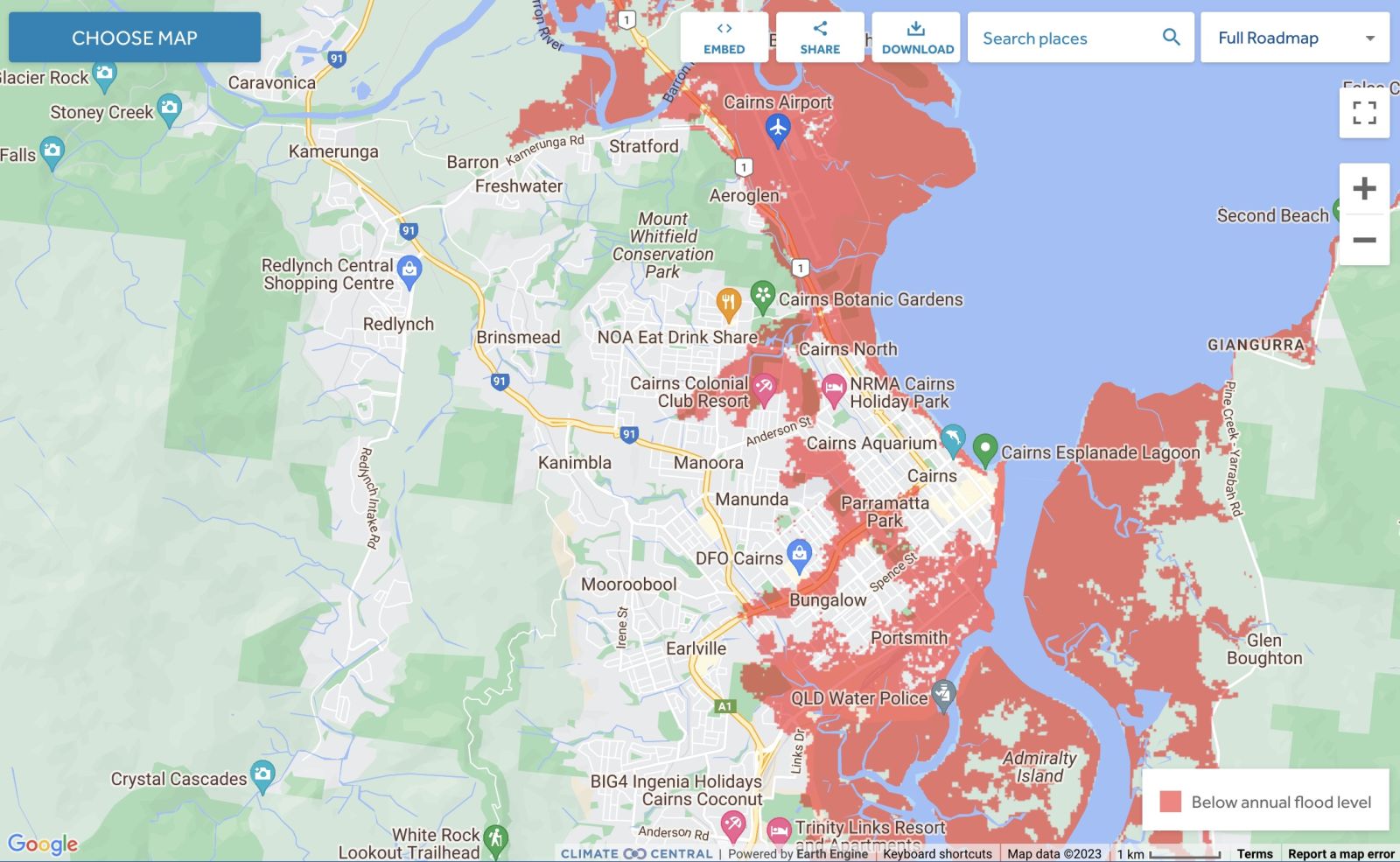
Land projected to be below annual flood level in 2050
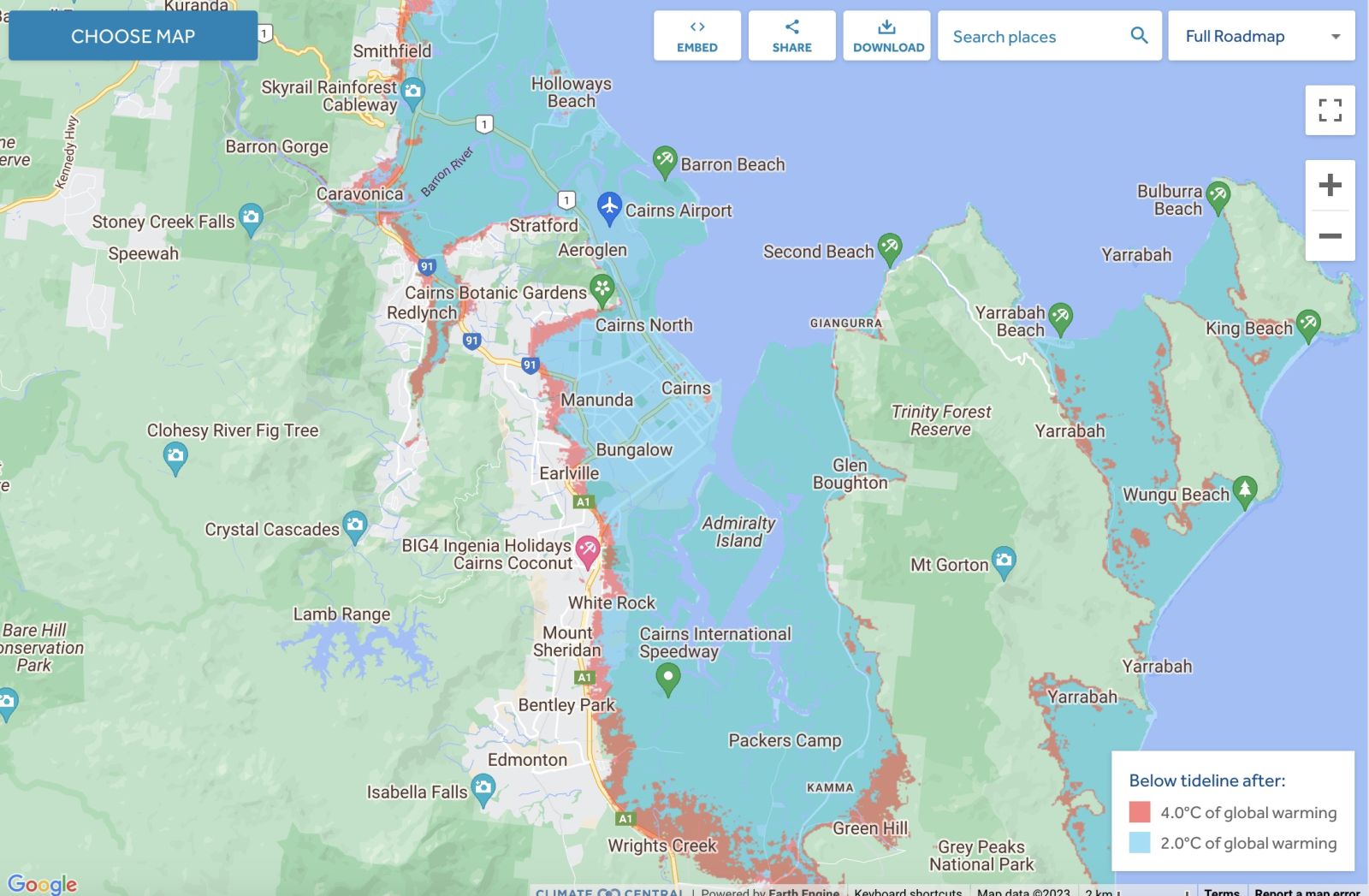
Comparison: long-term sea level outcomes
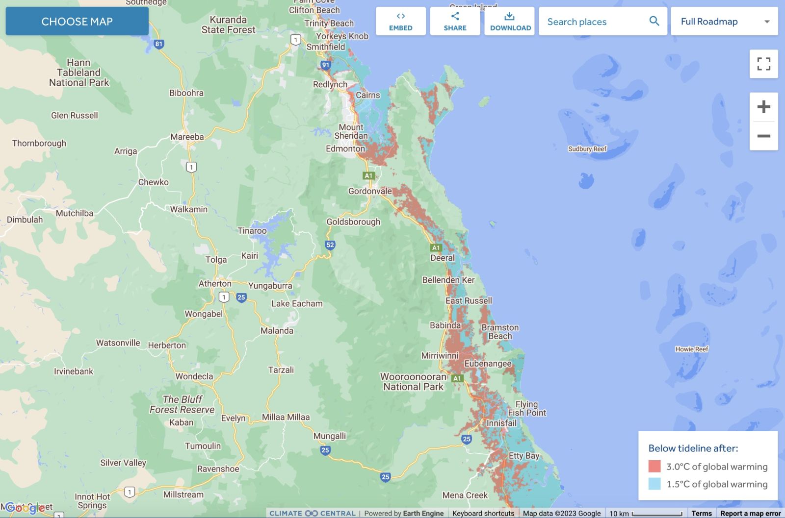
Comparison: long-term sea level outcomes
|
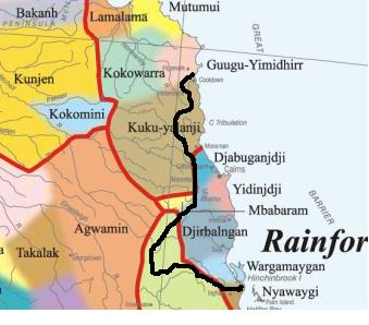
Aboriginal Australia:
|
|
|
NOTE1: Likely indicators only; for original Aboriginal Australia Map © 1991 & restrictions on its copy & use, see Aboriginal Australia Map NOTE2: The red line is part of the original Aboriginal Australia Map © 1991. The black line is added by Bloggerme for discussion only. It shows the likely State boundary based on the flow of water only. As "the ridge" (See FOWTOR) naturally impacts on the development of the language, social or nation groups of the Indigenous people of Australia, the proposed border is often identical to the group boundary shown on the Aboriginal Australia Map. This is as was expected. Variations are social/historical & result in a particular language, social or nation group being represented in two adjoining States. |
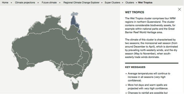
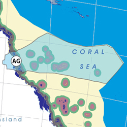
Other regional projections - CSIRO part of Wet Tropics region
The CSIRO has regions for projecting the impact of Climate Change. See https://www.climatechangeinaustralia.gov.au/en/climate-projections/futur... This state, Carpentaria State (C), is one of the clear projections in a CSIRO cluster called "Monsoon North region". CSIRO's Wet Tropics region coincides exactly with BloggerMe's A,B,AG.
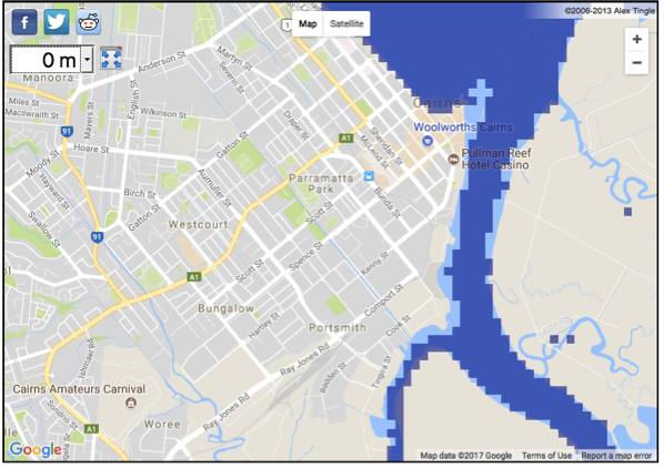
Cairns - current sea level 2017
The current sea level 2017 needs to be understood in the context of rising sea levels. See below:
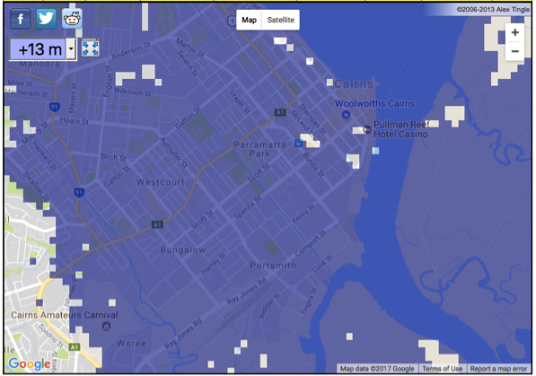
Cairns - impact of 13m sea level rise - 20??
A recent scientific impact test by US scientists in the Antarctica suggests that the global warming at present happening across the world will cause a crash of glacial caps in the Antarctica will transform an expected 13 ft (4 metres) sea level rise to a 13 metres sea level rise arising from Antarctica alone. When this happens, Cairns will be taken out.
Read more:
http://www.rollingstone.com/politics/features/the-doomsday-glacier-w481260
https://www.theverge.com/2017/9/26/16363158/antarctica-glaciers-melting-...
To do your own calculations, try here: http://geology.com/sea-level-rise/
Nuclear weapons
Centre ground zero CGZ - Cairns - 475 kilotons (431 kilotonnes)
https://nuclearsecrecy.com/nukemap/
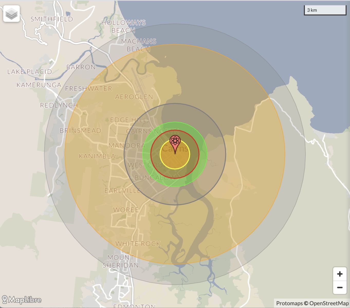
NB: population 10km around Cairns CBD LEGEND
https://australia.places-in-the-world.com/11703914-places-within-10km-ar...
Population taken out by nuclear weapon = 95,791
Click here to:
Comments
Twitter
Thu, 22/11/2012 - 8:18am
Permalink
Tourism
ABC Far North QLD @ABCFarNorth
Cairns airport passenger numbers to take off http://bit.ly/Tam99n
Twitter
Thu, 22/11/2012 - 5:57am
Permalink
Tilt train
ABC Far North QLD @ABCFarNorth
Tilt train derailment report released http://bit.ly/Xua2uT
Twitter
Thu, 22/11/2012 - 5:29am
Permalink
Mareeba
ABC Far North QLD @ABCFarNorth
#AntiquesOnTheWireless is a hit! Come to the Mareeba Heritage Museum - bring your collectables! pic.twitter.com/hdbOGgjc
Twitter
Tue, 20/11/2012 - 4:08am
Permalink
drink-driving problem?
ABC Far North QLD @ABCFarNorth
Does Cairns have a drink-driving problem? According to police we have a serious one with one driver recording... http://fb.me/1Ww47RkaB
Twitter
Fri, 16/11/2012 - 9:43pm
Permalink
Cape Tribulation
ABC Far North QLD @ABCFarNorth
Nut grass, grasshoppers and keeping bugs off your tomatoes just some of the hot topics in the week's tropical... http://fb.me/1dVeWkImU
Twitter
Thu, 15/11/2012 - 12:29pm
Permalink
eclypse
Ben Cubby @bencubby
Science reporter @NickySMH takes time out from her Cairns resort to sling us a lazy 500 words on the solar #eclipse. http://bit.ly/PU4PYF
Twitter
Thu, 15/11/2012 - 12:04pm
Permalink
NQ World Heritage
ILC UNSW @ILC_UNSW
25yrs after World Heritage listing of NQ tropics Feds officially recognise significance of rainforest cultural heritage http://www.abc.net.au/rural/qld/content/2012/11/s3632904.htm …
Twitter
Wed, 14/11/2012 - 1:12pm
Permalink
Cairns eclipse ... teases
ABC Far North QLD @ABCFarNorth
Cairns #eclipse2012 teases umbraphiles http://bit.ly/W6j6je
Twitter
Wed, 14/11/2012 - 11:56am
Permalink
Southern Surveyor leaves Cairns ...
CSIRO @CSIROnews
Blog: Onboard Southern Surveyor with Dr Maria Seton from @Sydney_Uni http://ow.ly/fgxXt
Twitter
Wed, 14/11/2012 - 2:18am
Permalink
Mining jobs
ABC Far North QLD @ABCFarNorth
Cairns residents quizzed about FIFO potential http://bit.ly/TBWxkh
Twitter
Wed, 14/11/2012 - 2:16am
Permalink
total solar eclipse
CSIRO @CSIROnews
Will you catch the total solar eclipse tomorrow? Here are viewing times, tips & a little geometry: http://ow.ly/feC6p
Twitter
Wed, 14/11/2012 - 2:05am
Permalink
eclipse
ABC Far North QLD @ABCFarNorth
Police want patience as clouds loom ahead of eclipse http://tinyurl.com/aep7a47 @QLDOnline #eclipse2012
Twitter
Mon, 12/11/2012 - 7:45am
Permalink
Cultural significance
ILC UNSW @ILC_UNSW
THE Wet Tropics has been recognised by Federal govt for its indigenous cultural significance to Australia. http://www.cairns.com.au/article/2012/11/09/236218_local-news.html …
Twitter
Fri, 09/11/2012 - 1:10pm
Permalink
Coral is under threat
ABC Far North QLD @ABCFarNorth
Saudi, Australian experts unite to save coral http://bit.ly/TwdOLA
Twitter
Fri, 09/11/2012 - 1:31am
Permalink
Barron river inhabitants
ABC Far North QLD @ABCFarNorth
FNQ Indigenous community raises housing concerns http://bit.ly/STbl2G
(Editor: See http://en.wikipedia.org/wiki/Barron_River_%28Queensland%29
Twitter
Fri, 09/11/2012 - 1:02am
Permalink
Eclipse
ABC Far North QLD @ABCFarNorth
Are you a photographer? Will you be shooting this month's eclipse? What tips do you have for us novices? http://fb.me/2eVwqyD18
Twitter
Fri, 09/11/2012 - 12:56am
Permalink
Eclipse
cooktown cape york @mycooktown
Live webcast of Cairns Eclipse 2012 http://ustre.am/OpJ8
Steve Irons
Wed, 07/11/2012 - 1:32pm
Permalink
Social Inclusion Week
CNS Regional Council @councilcairns
#Cairns Social Inclusion Week Celebration Sat 24 Nov 6:30-11pm - Cairns West Community Centre http://ow.ly/ePZrn
Twitter
Wed, 07/11/2012 - 1:33am
Permalink
Tobruk Pool
The 4868 Report @4868Report
Have your say about the future of Tobruk Pool! http://wp.me/pxrgh-79S via @wordpressdotcom
Twitter
Wed, 07/11/2012 - 1:31am
Permalink
Cairns Hospital
The 4868 Report @4868Report
Cairns Hospital Redevelopment - Exclusive New Video! http://wp.me/pxrgh-7bc
Twitter
Mon, 05/11/2012 - 1:26pm
Permalink
Total solar eclipse
vexnews @vexnews
Total solar eclipse will plunge Cairns into darkness Nov 14, but also be visible as a partial eclipse across Australia http://bit.ly/SLrGpT
Twitter
Mon, 05/11/2012 - 12:57pm
Permalink
Malanda
ABC Far North QLD @ABCFarNorth
Have you met one of the Royal family? In 1966 Peter English gave Prince Charles a tour of the 'Malanda... http://fb.me/1N3kcBIYa
Twitter
Mon, 05/11/2012 - 12:56pm
Permalink
Malanda Jungle
ABC Far North QLD @ABCFarNorth
Cheers big ears: Peter English's royal encounter http://tinyurl.com/dyb757y
Twitter
Sun, 04/11/2012 - 6:36am
Permalink
Atherton
ABC Far North QLD @ABCFarNorth
Mayor rejects fluoridation push http://bit.ly/RvmpSA
Twitter
Sun, 04/11/2012 - 5:47am
Permalink
Solar eclipse
ABC Far North QLD @ABCFarNorth
Solar eclipse fanatics flock to Cairns http://bit.ly/Qcbm2e
Twitter
Sat, 03/11/2012 - 5:36pm
Permalink
Cape Tribulation-Mulligan
CNS Regional Council @councilcairns
Public Info sessions re: Cape Tribulation-Mulligan H'way link road- #cooktown wujal wujal Cape Trib Cow Bay & #Mossman http://ow.ly/eMyME
Twitter
Fri, 02/11/2012 - 4:37pm
Permalink
Art
CNS Regional Council @councilcairns
Do you know any arty folk aged 13 years & under...? Prizes up for grabs! http://ow.ly/eXFRk
Twitter
Sat, 27/10/2012 - 5:27pm
Permalink
Ferry
CNS Regional Council @councilcairns
#Daintree Ferry open from 4am 14 Nov re: @Cairns_Eclipse - access to viewing north of river such as Cape Kimberly+Cape Tribulation.
Twitter
Fri, 26/10/2012 - 4:29pm
Permalink
Poisonous cannisters on the beach
CNS Regional Council @councilcairns
IMPORTANT alert from @QPSmedia RT @cairnsnews: Poisonous canisters continue to wash up on Far Northern beaches http://www.cairns.com.au/article/2012/10/26/235694_local-news.html …
Twitter
Thu, 25/10/2012 - 4:52pm
Permalink
We don't like reggae ... Oh no!
CNS Regional Council @councilcairns
FREE #family friendly reggae concert in Fogarty Park this Sunday. #Cairns http://ow.ly/eKEp3
Steve Irons
Sun, 14/10/2012 - 3:11am
Permalink
Rough draft - Great Barrier Reef
http://bloggerme.com.au/super-state-1-great-barrier-reef
Pages
Add new comment