Thanks for checking this Region out.
This Region is prepared on the a-political concept that if you are interested in 'place' in Australia, the most important aspect that defines 'place', is the 'flow of water'. The Senate is interested in 'place'.
This Region defines its boundaries at the top of the ridge, where water flows one way rather than the other. This leads to a very interesting 'place'.
We are seeking a debate with people who live in this proposed new Region. We know we've got the Region pretty well correct; after all, it's just geography. But if you live in this Region you can tell us a lot of interesting things.
- Do these boundaries define a place that is unique; different to every other Region in Australia? We think that that is probably quite likely.
- Is it a great place, worthy of recognition?
- Upon formation, what should be the name of this Region? Who would be the Lord Mayor? Who would be the two Senators who represent this Region? Who would be the additional Senator that represents the interests of Aboriginal & Torres Strait Islander peoples in this region? What benefit would flow from a concept of super-Regions for the whole of the Red Centre?
- Would life be enhanced if it was on a fast Ring-Rail that links the Capital City to every other Capital City in Australia?
- Many other interesting things!
We think that this is a great new concept of regional statehood based on real concepts that define life in this particular Region. What do you think?
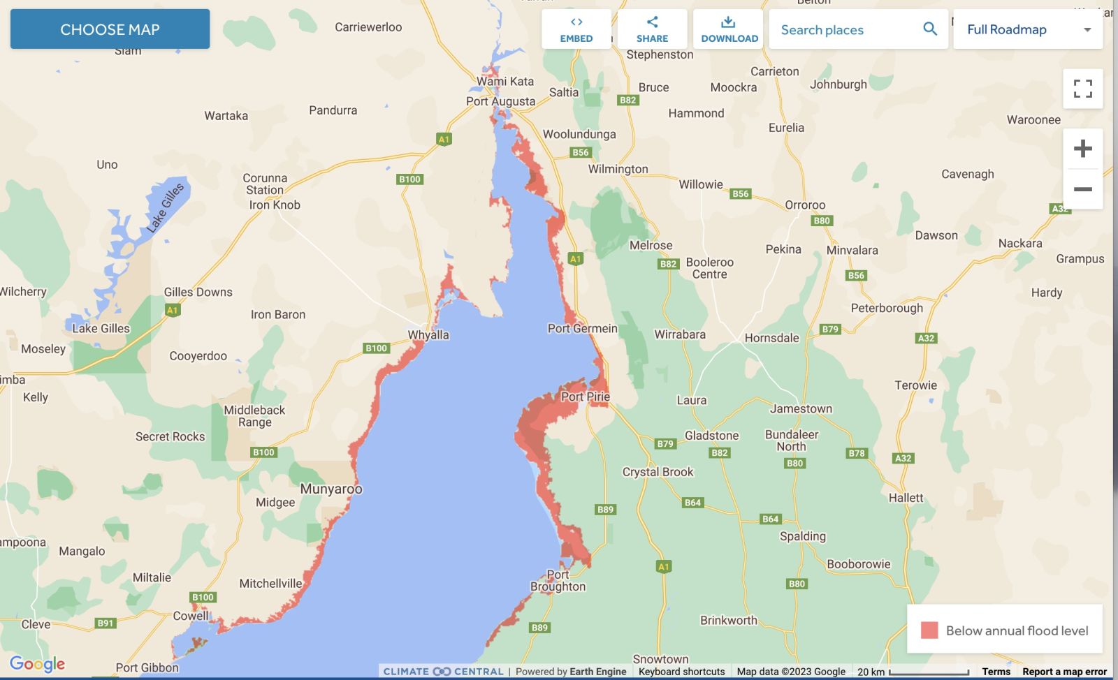
Land projected to be below annual flood level in 2050
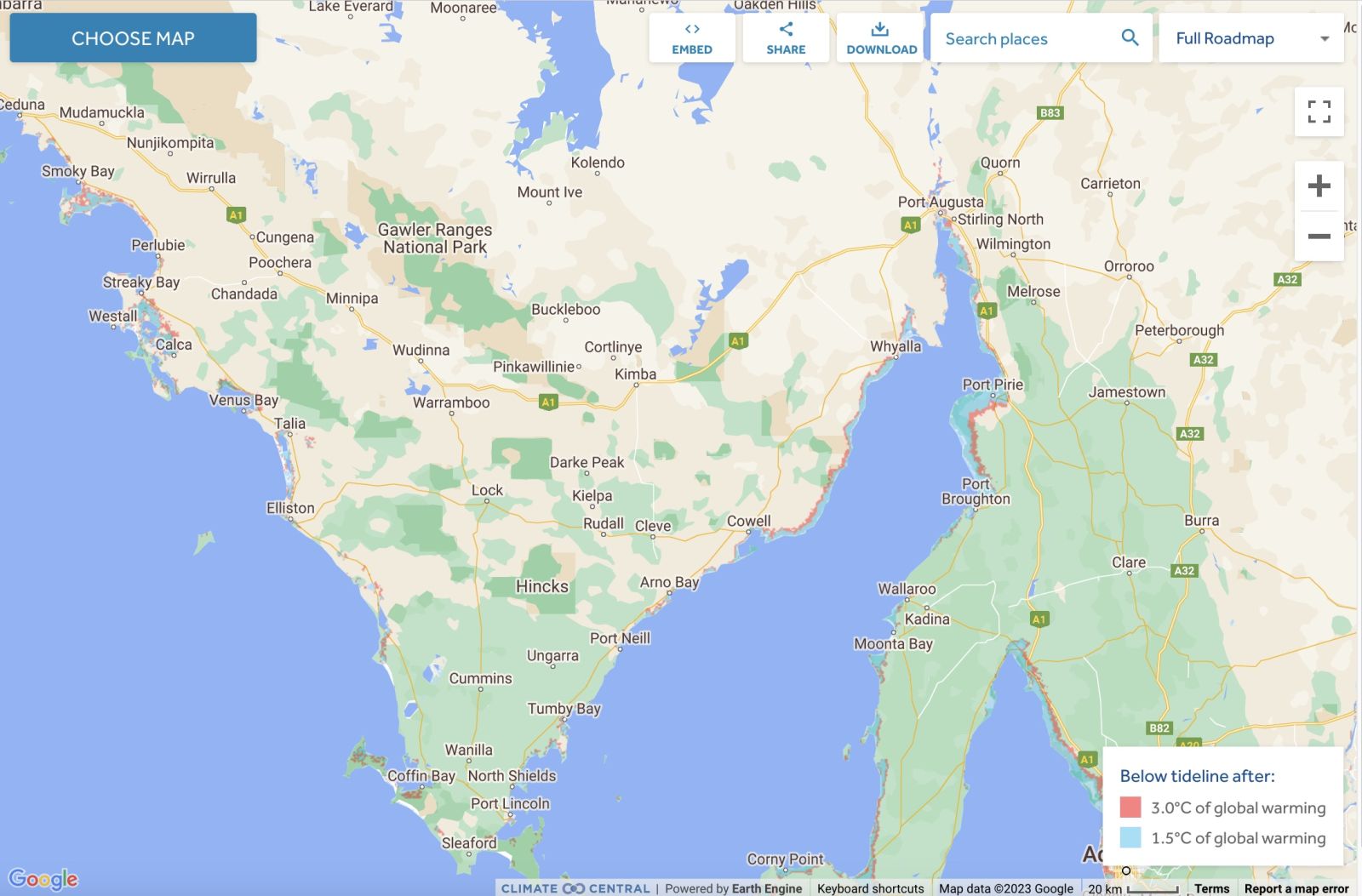
Comparison: long-term sea level outcomes
|
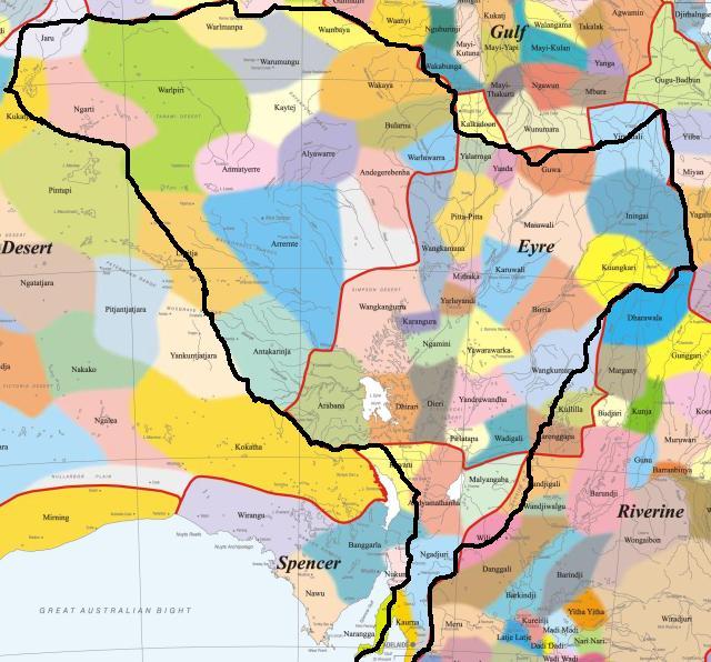
Aboriginal Australia:
|
|
|
NOTE1: Likely indicators only; for original Aboriginal Australia Map © 1991 & restrictions on its copy & use, see Aboriginal Australia Map NOTE2: The red line is part of the original Aboriginal Australia Map © 1991. The black line is added by Bloggerme for discussion only. It shows the likely State boundary based on the flow of water only. As "the ridge" (See FOWTOR) naturally impacts on the development of the language, social or nation groups of the Indigenous people of Australia, the proposed border is often identical to the group boundary shown on the Aboriginal Australia Map. This is as was expected. Variations are social/historical & result in a particular language, social or nation group being represented in two adjoining States. |
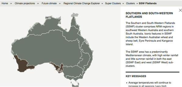 |
Other regional projections - CSIRO part of Southern & South-Western Flatlands regionThe CSIRO has regions for projecting the impact of Climate Change. See https://www.climatechangeinaustralia.gov.au/en/climate-projections/futur... A small s. of this state, Uluru Central State (R), is included in a CSIRO cluster called "Southern & South-Western Flatlands region". CSIRO's Southern & South-Western Flatlands region coincides with BloggerMe's N,P,Q, and a tiny bit of X and a tiny bit of R. |
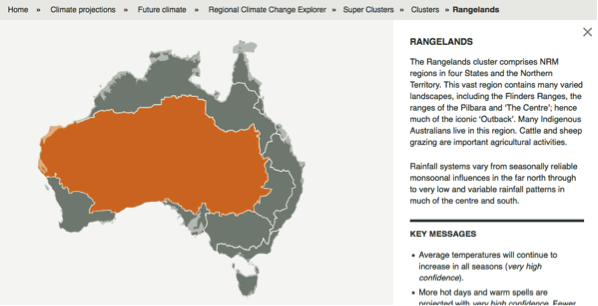 |
Other regional projections - CSIRO part of Rangelands regionThe CSIRO has regions for projecting the impact of Climate Change. See https://www.climatechangeinaustralia.gov.au/en/climate-projections/futur... This state, Uluru Central State (R), is one of the clear projections in a CSIRO cluster called "Rangelands region". CSIRO's Rangelands region coincides with BloggerMe's L,M,X (missing a tiny bit), R (missing a tiny bit, shown above), but includes a large bit of S (the Darling River bit). |
Nuclear weapons
Centre ground zero CGZ - Pine Gap (Alice Springs) - 475 kilotons (431 kilotonnes)
https://nuclearsecrecy.com/nukemap/
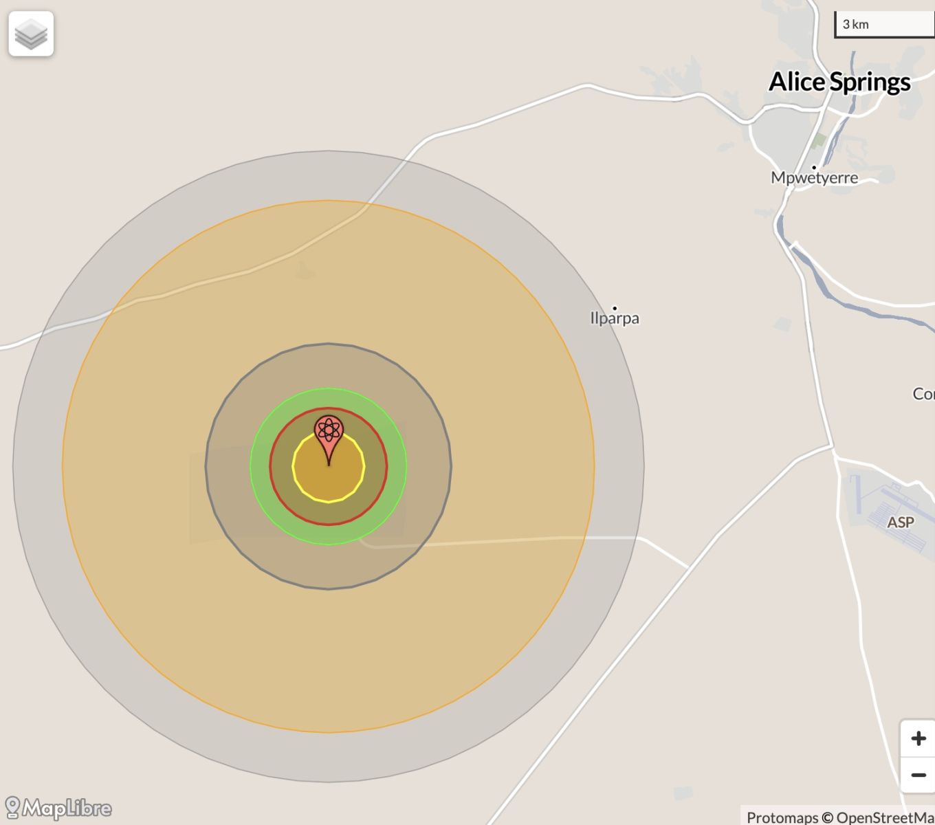
NB: population 10km around Alice Springs CBD LEGEND
https://australia.places-in-the-world.com/2077895-places-within-10km-aro...
Population taken out by nuclear weapon = 26,676
Click here to:
Comments
Twitter
Thu, 25/10/2012 - 5:39pm
Permalink
Food shortages?
Top End Tweets @TopEndTweets
Food store licensing expanded: The whole of the Northern Territory is now defined as a food security are... http://j.mp/XkdLYZ
Twitter
Thu, 25/10/2012 - 2:06pm
Permalink
Dingos vs feral cats!
Top End Tweets @TopEndTweets
Dingo numbers linked to feral cat control: Researchers say the presence of dingoes in Central and Northe... http://j.mp/VGtSlw #topend
Twitter
Thu, 25/10/2012 - 12:43pm
Permalink
Fire in Thargomindah
CSIRO @CSIROnews
Amazing pictures capture fire tornado in western QLD http://ow.ly/eKsIl
Twitter
Thu, 25/10/2012 - 1:30am
Permalink
Art - Alice style
Top End Tweets @TopEndTweets
Namatjira descendants look to their future: Many Hands Art Centre going through a restructure after r... http://j.mp/SkvUBP
Steve Irons
Thu, 18/10/2012 - 5:52am
Permalink
A ROUGH DRAFT
Steve Irons
Sat, 29/09/2012 - 1:35pm
Permalink
Place of the Alice in airline infractucture
In this plan the Alice plays a huge part in airline infrastructure. Check out the briefing:
http://www.bloggerme.com.au/background-briefings#airline
Check out the map:
http://bloggerme.com.au/airline-infrastructure
How exciting is that?
Steve Irons
Sat, 29/09/2012 - 1:31pm
Permalink
The place of the Alice in integrated rail infrastructure
In this plan the Alice plays a huge part in integrated rail infrastructure. Check out the briefing:
http://www.bloggerme.com.au/background-briefings#integrated
Check out the map:
http://bloggerme.com.au/rail-infrastructure
Pages
Add new comment