Thanks for checking this Region out.
This Region is prepared on the a-political concept that if you are interested in 'place' in Australia, the most important aspect that defines 'place', is the 'flow of water'. The Senate is interested in 'place'.
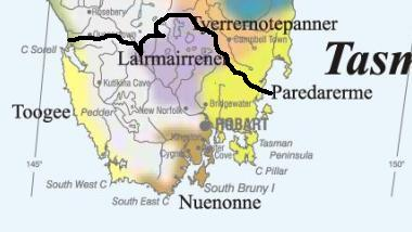
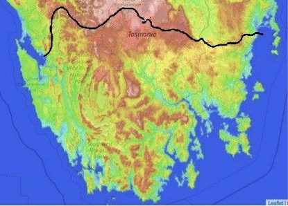
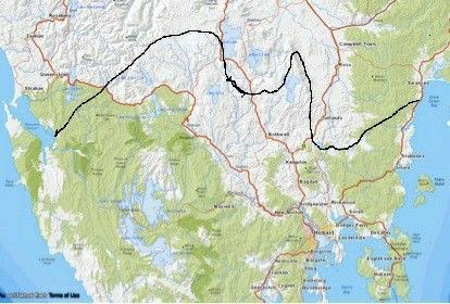
This Region defines its boundaries at the top of the ridge, where water flows one way rather than the other. This leads to a very interesting 'place'.
We are seeking a debate with people who live in this proposed new Region. We know we've got the Region pretty well correct; after all, it's just geography. But if you live in this Region you can tell us a lot of interesting things.
- Do these boundaries define a place that is unique; different to every other Region in Australia? We think that that is probably quite likely.
- Is it a great place, worthy of recognition?
- Upon formation, what should be the name of this Region? Who would be the Lord Mayor? Who would be the two Senators who represent this Region? Who would be the additional Senator that represents the interests of Aboriginal & Torres Strait Islander peoples in this region? What benefit would there be in seeing the island as a super region made up of three regions? What benefit would flow from (Southern Ocean) regions coming together to look after special interests in the Antarctica, or one of our Senators having a special responsibility for Antarctica, as a super region, at present under serious risk?
- Would life be enhanced if it was on a fast Ring-Rail that links the Capital City to other capital cities on the island and to every other Capital City on the mainland?
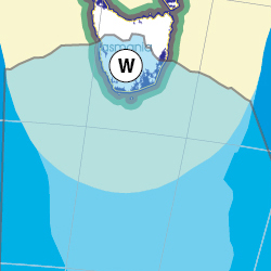
Land projected to be below annual flood level in 2050
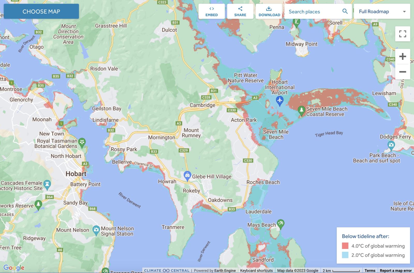
Comparison: long-term sea level outcomes
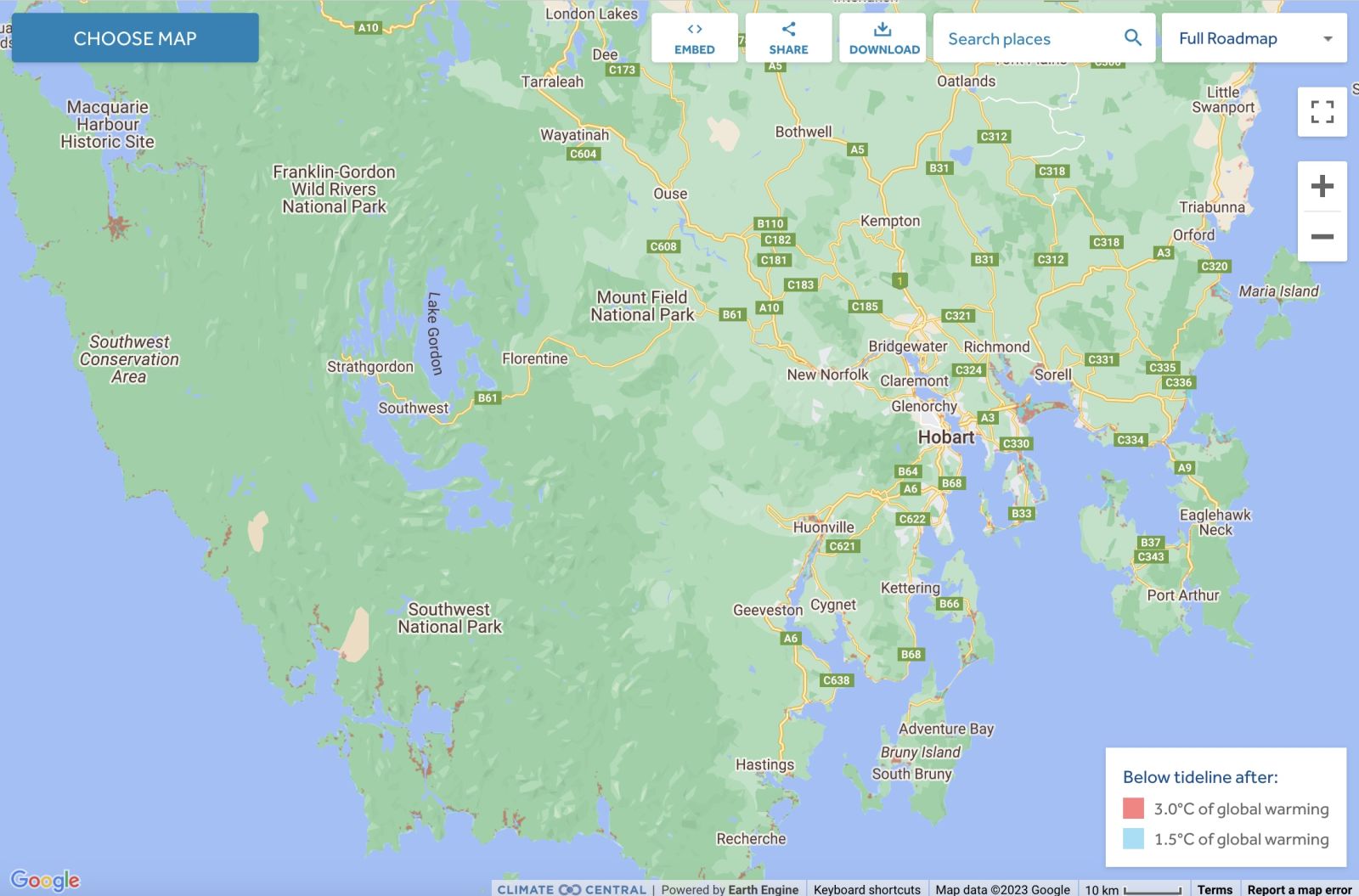
Comparison: long-term sea level outcomes
|
Aboriginal Australia:
|
|
|
NOTE1: Likely indicators only; for original Aboriginal Australia Map © 1991 & restrictions on its copy & use, see Aboriginal Australia Map NOTE2: The black line is added by Bloggerme for discussion only. It shows the likely State boundary based on the flow of water only. As "the ridge" (See FOWTOR) naturally impacts on the development of the language, social or nation groups of the Indigenous people of Australia, the proposed border is often identical to the group boundary shown on the Aboriginal Australia Map. This is as was expected. Variations are social/historical & result in a particular language, social or nation group being represented in two adjoining States. |
https://www.pinterest.com.au/pin/418553359123599267/
https://www.pinterest.com.au/pin/418553359123654245/
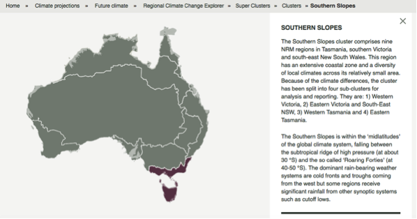
Other regional projections - CSIRO part of Southern Slopes region
The CSIRO has regions for projecting the impact of Climate Change. See https://www.climatechangeinaustralia.gov.au/en/climate-projections/futur... This state, SE Cape State (W), is one of the clear projections in a CSIRO cluster called "Southern Slopes region". CSIRO's Southern Slopes region coincides exactly with BloggerMe's T,O,U,V,W.
Regionalism - Aged Care Planning (Southern Region ) 2018
https://www.gen-agedcaredata.gov.au/Resources/Access-data/2018/May/Aged-...

Nuclear weapons
Centre ground zero CGZ - Hobart - 475 kilotons (431 kilotonnes)
https://nuclearsecrecy.com/nukemap/
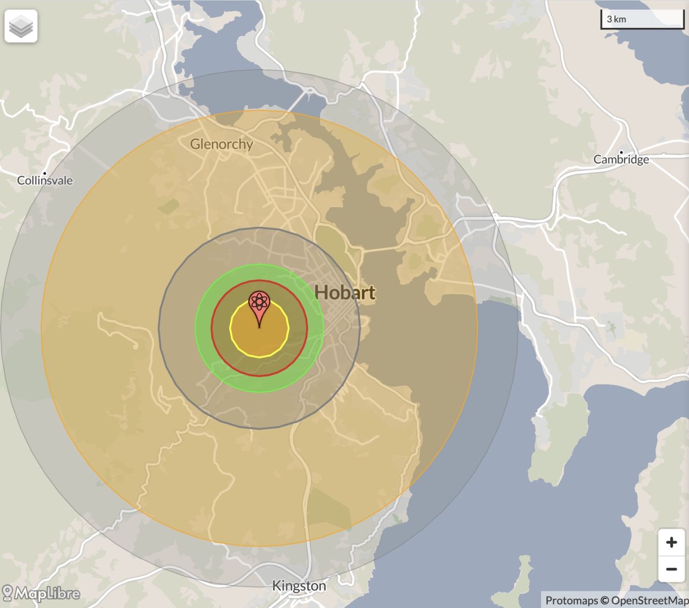
NB: population 10km around Hobart CBD LEGEND
https://australia.places-in-the-world.com/11523836-places-within-10km-ar...
Population taken out by nuclear weapon = 117,056
Click here to:
Comments
Steve Irons
Fri, 02/10/2020 - 4:11pm
Permalink
Beauty
Port Arthur Remarkable Cave
https://www.pinterest.com/pin/418553359094096710/
Tasman Island
https://www.pinterest.com/pin/418553359093933434/
Remarkable Cave (that's its name) south of Port Arthur
https://www.pinterest.com/pin/418553359094093419/
Devils Kitchen Cliffs
https://www.pinterest.com/pin/418553359093986617/
Eagle Hawke Neck
https://www.pinterest.com/pin/418553359093986701/
Bruny Island
https://www.pinterest.com/pin/418553359094156052/
Port Arthur
https://www.pinterest.com/pin/418553359094408297/
Cascade Brewery, Hobart
https://www.pinterest.com/pin/418553359094434079/
Hobart, docks
https://www.pinterest.com/pin/418553359094739420/
Cox Bight, South Coast Track
https://www.pinterest.com/pin/418553359094781791/
Rheban Beach, Orford
https://www.pinterest.com/pin/418553359095023550/
Rheban Beach, Orford
https://www.pinterest.com/pin/418553359095023569/
Snow gums, in Navarre Plains south of Lake St Clair
https://www.pinterest.com/pin/418553359095040323/
Howrah Beach, Hobart
https://www.pinterest.com/pin/418553359095112852/
Lake Echo
https://www.pinterest.com/pin/418553359095124295/
Gordon River
https://www.pinterest.com/pin/418553359095176441/
Hobart, coast, after the storm, sunbeams
https://www.pinterest.com/pin/418553359095204709/
New Norfolk & Derwent River panorama from Pulpit Rock
https://www.pinterest.com/pin/418553359095204821/
Ruins, Port Arthur
https://www.pinterest.com/pin/418553359095218110/
Tasman Bridge crossing the Derwent River
https://www.pinterest.com/pin/418553359095228386/
Kunanyi/Mt Wellington
https://www.pinterest.com/pin/418553359095277830/
Fortescue Bay, Tasman National Park
https://www.pinterest.com/pin/418553359095278212/
Adventure Bay, Bruny Island
http://www.bloggerme.com.au/states/se-cape
Pumphouse Point, Lake St Clair
https://www.pinterest.com/pin/418553359095305741/
Cape Bruny
https://www.pinterest.com/pin/418553359095305895/
Cliff Creek, Styx River rainforest
https://www.pinterest.com/pin/418553359095306528/
Little treasures in the Styx rainforest
https://www.pinterest.com/pin/418553359095306564/
Eddystone Rock, wild waters
https://www.pinterest.com/pin/418553359095346435/
Russell Falls, Russell Falls Creek, Tyenna River, Derwent River
https://www.pinterest.com/pin/418553359095477490/
That's Bruny Island out there
https://www.pinterest.com/pin/418553359095759192/
Coal River Valley
https://www.pinterest.com/pin/418553359095930654/
Russell Falls
https://www.pinterest.com/pin/418553359097845202/
Converted industrial, Hobart
https://www.pinterest.com/pin/418553359097834443/
Maria Island
https://www.pinterest.com/pin/418553359097834446/
Strahan Village, West Coast
https://www.pinterest.com/pin/418553359099186086/
Steve Irons
Thu, 04/04/2013 - 2:50am
Permalink
Antarctic sea ice bucks trend
"Unlike in the Arctic, where sea ice has suffered a drastic decline in recent years, a Dutch study has shown that sea ice in the Antarctic has expanded significantly since 1985 ..."
Research Brief: The Conversation
Read more: https://theconversation.com/antarctic-sea-ice-bucks-trend-13195
Steve Irons
Thu, 04/04/2013 - 2:13am
Permalink
Final frontiers: Antarctica
"With the global population now well over seven billion there are few remaining parts of the world relatively untouched by human activity. We assess the current state and future prospects of five final frontiers: rainforests, Antarctica, the Arctic, the deep sea and space.
"Antarctica is the coldest, highest, driest continent – and the one which bears the smallest footprint of human occupation. It is also the only continent designated as a “…natural reserve, devoted to peace and science”.
"So how is Antarctica faring? What are the human impacts on this, the last of continents, and what might the future hold?"
Tony Press CEO, Antarctic Climate & Ecosystems CRC at University of Tasmania The Conversation 3 April 2013, 6.32am
Read more: https://theconversation.com/final-frontiers-antarctica-13066
Steve Irons
Thu, 04/04/2013 - 2:03am
Permalink
Warning bells: Antarctica
"When it comes to climate change, temperature is only part of the story. Climate gases released by human activity are dissolving into the oceans, and the increased levels of COâ‚‚ are making the waters more acid. This process threatens marine life from coral reefs to fragile polar ecosystems. It seems likely that the polar oceans will be the first to feel the full force of ocean acidification. These cold seas may provide an important lesson for Australia’s warmer waters."
Simon Morley Researcher at British Antarctic Survey & Robert Day Associate Professor at University of Melbourne: The Conversation 3 April 2013, 2.15pm AEST
Read more: https://theconversation.com/warning-bells-what-antarctica-can-teach-us-a...
Twitter
Tue, 26/02/2013 - 7:22pm
Permalink
Antarctica
Ben Cubby @bencubby
Seals help scientists solve 30-year-old mystery. http://bit.ly/YrKmwU
Twitter
Wed, 20/02/2013 - 10:43am
Permalink
Huon Valley
Meredith Stanton @CloudsCreek
Status Report on Logging in the World Heritage nominated Tassie Forests Feb 2013 http://bit.ly/YAzUQo Take Action http://bit.ly/YAzR7b
Twitter
Sat, 09/02/2013 - 4:15am
Permalink
Antarctica
vexnews @vexnews
Quentin Bryce the first Australian Governor-General to visit Antarctica http://bit.ly/Xe0Mq3
Twitter
Tue, 29/01/2013 - 2:35am
Permalink
Uni of Tasmania: Fire management
FarmOnline @FarmOnline
Bushfire debate continues: AUSTRALIA'S land managers need a new culture of fire management of landscapes, Tasman... http://bit.ly/10V3D7V
Twitter
Fri, 18/01/2013 - 3:06pm
Permalink
After the burn
Christine Milne @senatormilne
Neil Haddon exhibition at Bett Gallery Hobart until 11Feb, After the Burn. pic.twitter.com/ukZn6uLY
Twitter
Fri, 11/01/2013 - 4:47am
Permalink
Dunalley
vexnews @vexnews
Video: Grandfather saves family by sheltering in the sea to escape lethal Tasmania wildfire: http://bit.ly/11eTUOw
Twitter
Thu, 10/01/2013 - 4:03am
Permalink
Sea Shepherd
Ben Cubby @bencubby
Bob Brown will replace Paul Watson at the helm of anti-whaling group Sea Shepherd in coming months. http://bit.ly/Zjs0LO
Twitter
Sat, 29/12/2012 - 6:44am
Permalink
Antarctic ice sheet melts
ILC UNSW @ILC_UNSW
A study shows the west Antarctic ice sheet is warming nearly twice as quickly as previously thought http://www.abc.net.au/news/2012-12-24/antarctic-ice-sheet-warming-faster-than-thought-study/4442722 …
Twitter
Sat, 29/12/2012 - 1:33am
Permalink
Huon Valley protection
Meredith Stanton @CloudsCreek
MR: Scrutiny of controversial support for Ta Ann http://wp.me/p29KjQ-iI via @Still_Wild @observertree1 Tassie forests still not protected!
Twitter
Wed, 19/12/2012 - 2:09am
Permalink
Antarctica
Ben Cubby @bencubby
Enviro minister Tony Burke has announced new Antarctic ice core drilling mission, in the Aurora Basin. Traces 2000yrs of #climate history.
Twitter
Tue, 18/12/2012 - 9:33am
Permalink
Impact of global warming
Ben Cubby @bencubby
Antarctica is being invaded by crabs. http://bit.ly/T8DlNQ
Twitter
Fri, 14/12/2012 - 4:27am
Permalink
Antarctica
Marcia Langton @marcialangton
King Crabs Poised to Wipe Out Rare Antarctic Ecosystem of Invertebrates: Scientific American http://www.scientificamerican.com/article.cfm?id=king-crabs-poised-to-wipe-out-rare-antarctic-ecosystem-of-invertebrates&WT.mc_id=SA_sharetool_Twitter …
Twitter
Fri, 07/12/2012 - 2:14am
Permalink
Super-state => Tasmanian devil
Ben Cubby @bencubby
Tassie devils are vulnerable to disease partly because their gene pool is more of a gene puddle. http://bit.ly/SH4ZTw #animals
Twitter
Thu, 06/12/2012 - 5:49am
Permalink
Southern ocean
Ben Cubby @bencubby
Sea Shepherd's Paul Watson is back, 4 months after skipping bail in Germany, and is chasing Japanese whalers again. http://bit.ly/VyZfub
Twitter
Thu, 06/12/2012 - 2:10am
Permalink
Franklin River
FarmOnline @FarmOnline
Bid to save green tape: A GROUP of Australia's most respected scientists is urging the federal government to aba... http://bit.ly/11Jd7Wb
Twitter
Sat, 01/12/2012 - 6:41am
Permalink
Melting ice
vexnews @vexnews
Antarctica, Greenland ice definitely melting into sea, and speeding up, experts warn http://bit.ly/V9dFzl
Twitter
Sat, 01/12/2012 - 6:26am
Permalink
Massive ice loss
Ben Cubby @bencubby
Here's the Nature journal piece on massive ice loss in both the Antarctic and Arctic. http://bit.ly/UeeYht #climate
Twitter
Sat, 01/12/2012 - 6:19am
Permalink
Melting Antarctica
Ben Cubby @bencubby
The Antarctic ice sheet is shrinking by an average of 71 billion tonnes a year, new study in the journal Science says. http://bit.ly/UvbjOr
Twitter
Sat, 17/11/2012 - 10:19pm
Permalink
Small parcels
ILC UNSW @ILC_UNSW
Tas Aboriginal community disappointed Legislative Council has delayed handing back relatively small parcels of land http://www.abc.net.au/news/2012-11-16/upper-house-defers-land-handback/4375234?section=tas …
Twitter
Thu, 15/11/2012 - 2:25pm
Permalink
highest annual organ donation
Lisa Singh @Lisa_Singh
Congrats to DonateLife TAS network and Royal Hobart Hospital on achieving highest annual organ donation ever http://www.donatelife.gov.au
Twitter
Fri, 09/11/2012 - 1:24pm
Permalink
Wool on show
FarmOnline @FarmOnline
Wool on show during Royal visit: AUSTRALIAN wool was took centre stage alongside Campaign for Wool patron HRH Pr... http://bit.ly/TbjKfw
Twitter
Fri, 09/11/2012 - 1:09am
Permalink
Young Hobart scientist breaking ground
CSIRO @CSIROnews
Congrats Lee Chang, for winning a Student Excellence Award @ausbiotech2012 for his work on biofuels http://ow.ly/f6VyN
Twitter
Sat, 03/11/2012 - 3:54pm
Permalink
Backward step?
ILC UNSW @ILC_UNSW
proposed Aboriginal Heritage Act slammed as a backward step by Tasmanian Aboriginal Centre and Michael Mansell http://www.examiner.com.au/story/570398/aboriginal-groups-slam-plan/?cs=94 …
Steve Irons
Fri, 02/11/2012 - 10:55pm
Permalink
RDA Blogs - Hobart
http://myregion.gov.au/blogs/living-disabilities
Twitter
Mon, 29/10/2012 - 4:55pm
Permalink
Forest negotiations
observertree @observertree1
Media Release: Conservationists call on government to take responsibility for forests. http://fb.me/2fhF3XQ5S
Twitter
Mon, 29/10/2012 - 4:46pm
Permalink
the world's largest marine reserve
Ben Cubby @bencubby
Antarctica is a step closer to getting the world's largest marine reserve, after international talks in Hobart. http://bit.ly/TiX1vr
Twitter
Sat, 27/10/2012 - 3:35pm
Permalink
Puppy farming
Tweeting Roo ™ @TweetingRoo
New law call for puppy farms - Tasmania Mercury http://shrtn.in/2NhbDX
Twitter
Sat, 27/10/2012 - 2:33pm
Permalink
Huon Valley under threat
observertree @observertree1
The Tasmanian forest negotiations have collapsed! http://fb.me/w52oed2t
Twitter
Fri, 26/10/2012 - 1:02am
Permalink
Bubble-jetting emperors in the Antarctica
CSIRO @CSIROnews
Must see RT @ausgeo: The winners of the most prestigious photography contest in the world have been announced. http://dlvr.it/2MnXCJ
Twitter
Wed, 24/10/2012 - 1:24pm
Permalink
CSIRO's research vessel
CSIRO @CSIROnews
Blog: Watch our next research vessel being built on @abc730 TAS http://ow.ly/eIyOW ^AW
Steve Irons
Fri, 19/10/2012 - 9:02pm
Permalink
Fred Gale
http://www.utas.edu.au/__data/assets/pdf_file/0020/153065/Fred_Gale_PPN2...
Steve Irons
Sat, 22/09/2012 - 1:48am
Permalink
Some initial parts
Add new comment