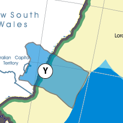
This Region is prepared on the a-political concept that if you are interested in 'place' in Australia, the most important aspect that defines 'place', is the 'flow of water'. The Senate is interested in 'place'.
This Region defines its boundaries at the top of the ridge, where water flows one way rather than the other. This leads to a very interesting 'place'.
We are seeking a debate with people who live in this proposed new Region. We know we've got the Region pretty well correct; after all, it's just geography. But if you live in this Region you can tell us a lot of interesting things.
- Do these boundaries define a place that is unique; different to every other Region in Australia? We think that that is probably quite likely.
- Is it a great place, worthy of recognition?
- Upon formation, what should be the name of this Region? Who would be the Lord Mayor? Who would be the two Senators who represent this Region? Who would be the additional Senator that represents the interests of Aboriginal & Torres Strait Islander peoples in this region?
- Would life be enhanced if it was on a fast Ring-Rail that links the Capital City to every other Capital City in Australia?
- Many other interesting things!
We think that this is a great new concept of regional statehood based on real concepts that define life in this particular Region. What do you think?
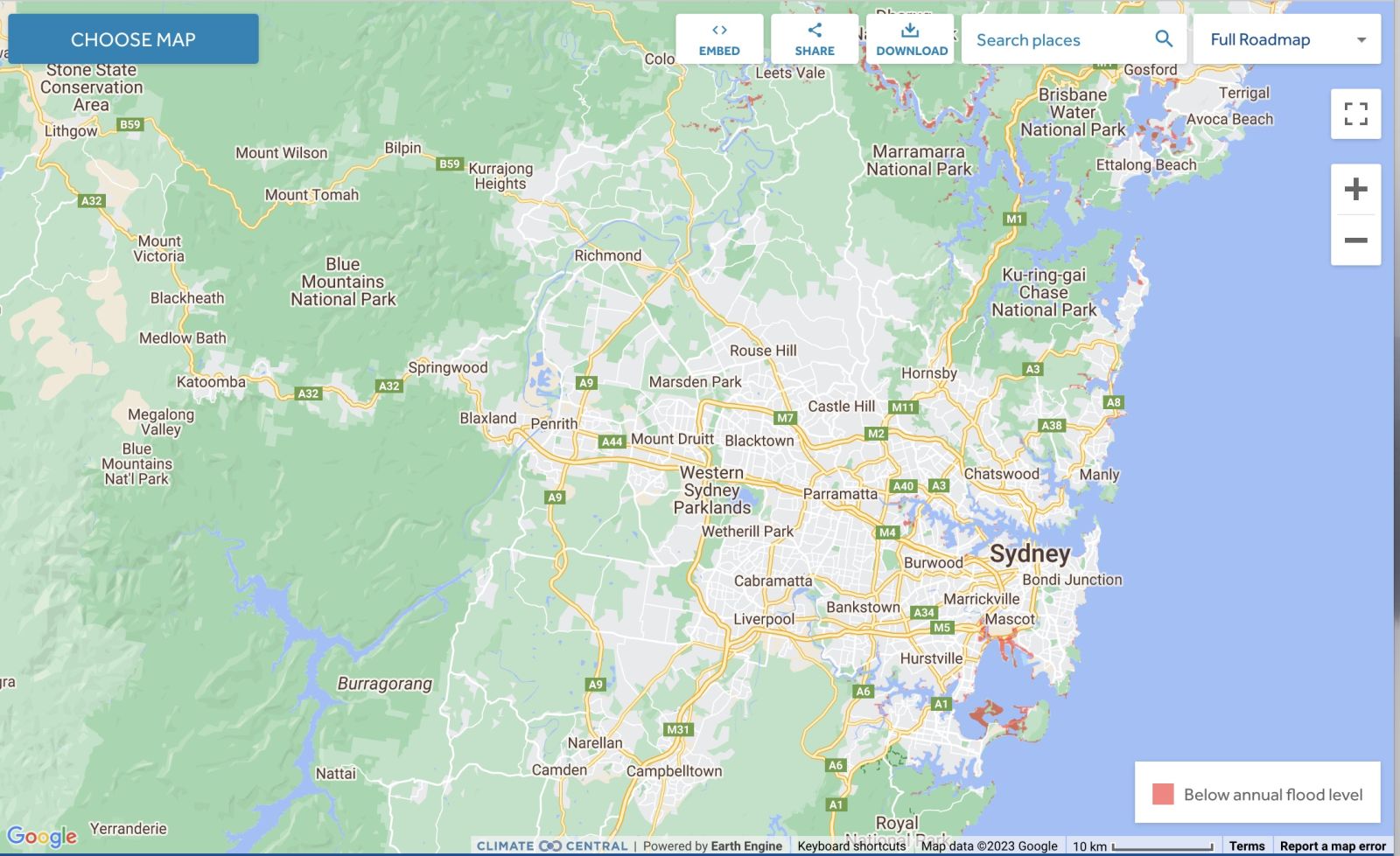
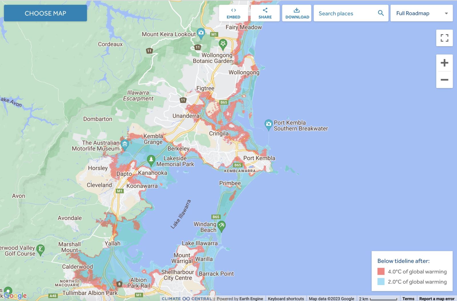
Land projected to be below annual flood level in 2050
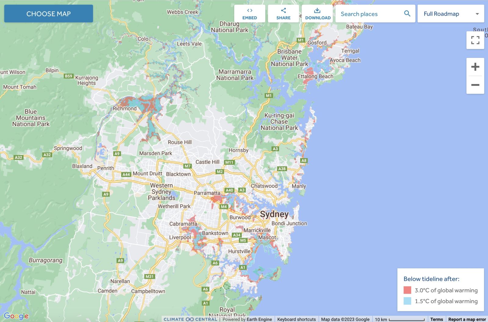
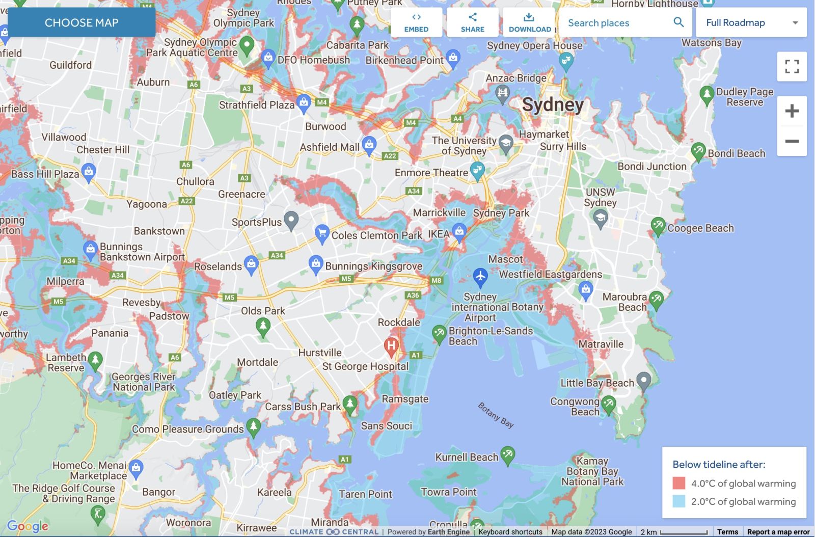
Explore sea level rise and coastal flood threats by adjusting the controls below.
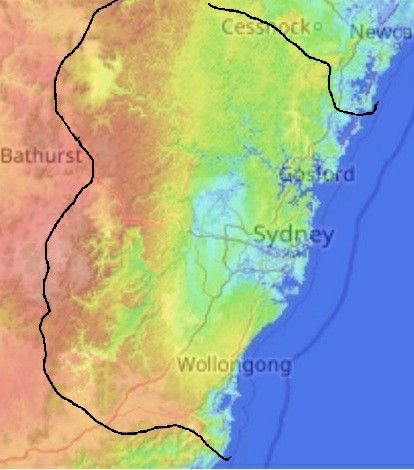
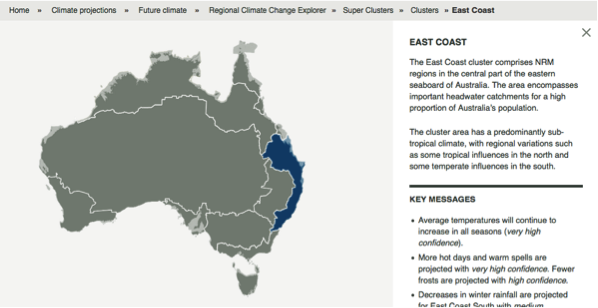
Other regional projections - CSIRO part of East Coast region
The CSIRO has regions for projecting the impact of Climate Change. See https://www.climatechangeinaustralia.gov.au/en/climate-projections/futur... This state, Narrabeen State (Y), is one of the clear projections in a CSIRO cluster called "East Coast region". CSIRO's East Coast region coincides exactly with BloggerMe's Y,Z,AA,AB,AC,AE
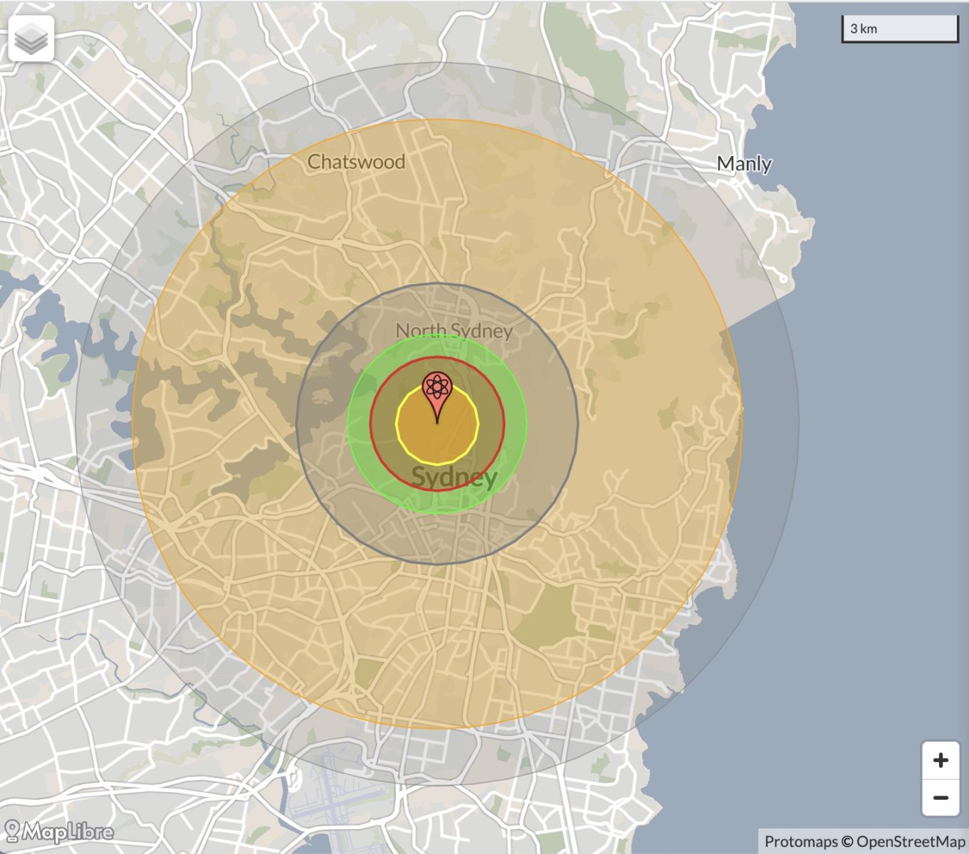
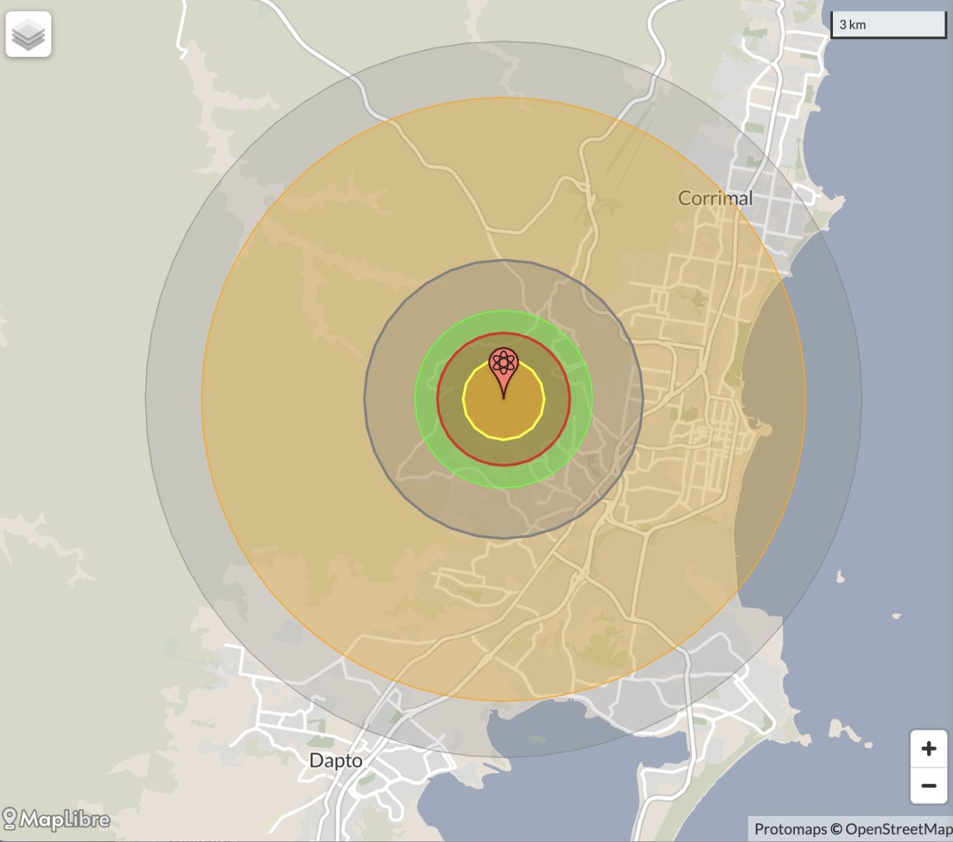
Nuclear weapons
Centre ground zero CGZ - Sydney - 475 kilotons (431 kilotonnes)
Thanks for taking the time to check us out. It's a proposal that will have a lot of traction by the time the real debate about a republic heats up. I am hoping to take an active role in that debate. Looking forward to it. Welcome to the Narrabeen State!
 \
\
Comments
Twitter
Mon, 26/11/2012 - 6:45am
Permalink
No backup
ILC UNSW @ILC_UNSW
"How can a hospital (Nepean) lose two months worth of data without any backup whatsoever?" http://m.smh.com.au/nsw/deleted-files-rob-family-of-answers-20121124-2a04m.html …
Twitter
Sat, 24/11/2012 - 12:06am
Permalink
Central Coast Arts
myregion website @myregionGovAu
Find out latest exciting #arts mentoring projects happening @RDACentralCoast on #myregion @WyongCouncil @mygosford http://ow.ly/fvKUL
Maria
Fri, 23/11/2012 - 7:49am
Permalink
my state
Didn't know I belonged to the Narrabeen state. Thanks for teaching me something new.
Steve Irons
Fri, 23/11/2012 - 6:01pm
Permalink
It's a proposal that will have a lot of
Thanks for taking the time to check us out. It's a proposal that will have a lot of traction by the time the real debate about a republic heats up. I am hoping to take an active role in that debate. Looking forward to it. Welcome to the Narrabeen State!
Twitter
Thu, 22/11/2012 - 6:00am
Permalink
trees in Marrickville
Ben Cubby @bencubby
There's a plan to cut down 1600 trees in Marrickville. Its council will vote tonight. http://bit.ly/UaLu4b
Twitter
Tue, 20/11/2012 - 3:27am
Permalink
South Sydney
vexnews @vexnews
Russell Crowe plans to sell South Sydney NRL team http://bit.ly/XQvskG
Twitter
Thu, 15/11/2012 - 2:29pm
Permalink
Residents to have a say
Wyong Shire Council @WyongCouncil
Wyong Shire Council, on the NSW Central Coast, is asking for residents to have a say about the area's future http://ow.ly/fiOP4
Twitter
Thu, 15/11/2012 - 12:41pm
Permalink
cool science events
CSIRO @CSIROnews
RT @csirohelix: Yo Sydney kids. These holidays we've got many cool science events in Dec & Jan. Book early! http://ow.ly/eTLG3
Twitter
Thu, 15/11/2012 - 12:27pm
Permalink
Botany Bay
Ben Cubby @bencubby
A dead whale is being savaged by sharks off Sydney. http://bit.ly/T3Jdtw via @OEHMedia
Twitter
Thu, 15/11/2012 - 12:09pm
Permalink
2012 Narrm Oration
ILC UNSW @ILC_UNSW
Professor Megan Davis delivers the 2012 Narrm Oration @marcialangton http://musse.unimelb.edu.au/november-12-99/professor-megan-davis-delivers-2012-narrm-oration …
Twitter
Thu, 15/11/2012 - 11:57am
Permalink
Richmond TAFE - the end of agriculture?
FarmOnline @FarmOnline
School’s out, but is it for good?: AN AIR of uncertainty surrounds agriculture students and lecturers at Richmon... http://bit.ly/ZuB5o5
Twitter
Thu, 15/11/2012 - 2:46am
Permalink
coal seam gas field
Ben Cubby @bencubby
Breaking: massive methane leaks uncovered in Australia's biggest coal seam gas field. http://bit.ly/SmpIIP
Twitter
Sat, 10/11/2012 - 11:46pm
Permalink
Gas drilling
Ben Cubby @bencubby
Coal seam gas drilling encroaches on suburban Sydney: 66 wells planned between Liverpool and Campbelltown. http://bit.ly/Q2WKlY
Twitter
Fri, 09/11/2012 - 1:52am
Permalink
whale calf in Sydney Harbour
Ben Cubby @bencubby
Attempt to free entangled whale calf in Sydney Harbour fails after another whale got "erratic and defensive". http://bit.ly/UxLk5h
Twitter
Tue, 06/11/2012 - 2:31am
Permalink
Bankstown & Wyong
Top End Tweets @TopEndTweets
http://indigenous.gov.au : Local Solutions Fund http://j.mp/RJr9k3
Steve Irons
Fri, 02/11/2012 - 8:26pm
Permalink
RDA Blogs - Central Coast
http://myregion.gov.au/blogs/digital-economic-development-willunga-style
Steve Irons
Fri, 02/11/2012 - 7:56pm
Permalink
RDA Blogs - The Hills
http://myregion.gov.au/blogs/hills-innovation-asset-and-financial-manage...
Twitter
Fri, 02/11/2012 - 2:12pm
Permalink
Redfern
NCIE @theNCIE
The City of Sydney Youth BBQ this arvo at 3:30pm at the Redfern Community Centre (The Block, Redfern). Head down for a feed & a yarn :)
Twitter
Fri, 02/11/2012 - 1:27pm
Permalink
Brisbane Water
Greg Bepper @gregbepper
O yeah!!.. next weekend! - Brisbane Water Oyster Festival http://www.oysterfestival.com.au
Twitter
Thu, 01/11/2012 - 1:04am
Permalink
Science - sydney uni
Tweeting Roo ™ @TweetingRoo
Laws will stifle research claim scientists - ABC-online http://shrtn.in/2PqyHc
Twitter
Wed, 31/10/2012 - 1:21pm
Permalink
Government denies funding for environmental body in Hunter
Max Phillips @maxphillips
EDITORIAL: Defending the defender "Denial of funding is a cowardly and undemocratic way to silence critics." http://www.theherald.com.au/story/465721/editorial-defending-the-defender/?cs=308 …
Twitter
Tue, 30/10/2012 - 10:59am
Permalink
Picton
Wollondilly Council @wdillycouncil
Community Strategic Plan 2030 Review - Community Participation Needed! Do you have an interest in helping to... http://fb.me/2lCpybRjA
Twitter
Sun, 28/10/2012 - 3:39pm
Permalink
Asbestos
Tweeting Roo ™ @TweetingRoo
Australia:> Union raises alarm on NSW asbestos - Herald Sun http://shrtn.in/2NtdnQ
Twitter
Fri, 26/10/2012 - 9:47pm
Permalink
Good food campaign
Clover Moore @CloverMoore
Have you seen @YFMSydney's @pozible campaign? A great project but be quick just 17 hrs to go http://bit.ly/QktoNU
Twitter
Fri, 26/10/2012 - 5:17pm
Permalink
Casino approval flawed
ILC UNSW @ILC_UNSW
"The people of Sydney will never see an independent analysis of the social and economic costs of the casino.'' http://m.smh.com.au/national/how-the-casino-deal-fell-into-packers-hands-20121025-288bc.html …
Twitter
Thu, 25/10/2012 - 1:09pm
Permalink
Nepean River -Are we going to let the mining company destroy it?
Sue Head @iamsuey
Coal seam gas spill threatens Nepean River #CSG http://wp.me/p2MtAy-4i
Steve Irons
Tue, 11/09/2012 - 1:34am
Permalink
"Sandbag City" Ben Cubby SMH September 11, 2012
http://m.smh.com.au/environment/climate-change/managed-retreat-to-sandba...
Pages
Add new comment