Thanks for checking this Region out.
This Region is prepared on the a-political concept that if you are interested in 'place' in Australia, the most important aspect that defines 'place', is the 'flow of water'. The Senate is interested in 'place'.
This Region defines its boundaries at the top of the ridge, where water flows one way rather than the other. This leads to a very interesting 'place'.
We are seeking a debate with people who live in this proposed new Region. We know we've got the Region pretty well correct; after all, it's just geography. But if you live in this Region you can tell us a lot of interesting things.
- Do these boundaries define a place that is unique; different to every other Region in Australia? We think that that is probably quite likely.
- Is it a great place, worthy of recognition?
- Upon formation, what should be the name of this Region? Who would be the Lord Mayor? Who would be the two Senators who represent this Region? Who would be the additional Senator that represents the interests of Aboriginal & Torres Strait Islander peoples in this region? What benefit would flow from regions coming together to look after the Snowy River?
- Would life be enhanced if it was on a fast Ring-Rail that links the Capital City to every other Capital City in Australia?
- Many other interesting things!
We think that this is a great new concept of regional statehood based on real concepts that define life in this particular Region. What do you think?
Land projected to be below annual flood level in 2050

Comparison: long-term sea level outcomes

Comparison: long-term sea level outcomes

|
Aboriginal Australia:
|
|
|
NOTE1: Likely indicators only; for original Aboriginal Australia Map © 1991 & restrictions on its copy & use, see Aboriginal Australia Map NOTE2: The red line is part of the original Aboriginal Australia Map © 1991. The black line is added by Bloggerme for discussion only. It shows the likely State boundary based on the flow of water only. As "the ridge" (See FOWTOR) naturally impacts on the development of the language, social or nation groups of the Indigenous people of Australia, the proposed border is often identical to the group boundary shown on the Aboriginal Australia Map. This is as was expected. Variations are social/historical & result in a particular language, social or nation group being represented in two adjoining States. |
https://www.pinterest.com.au/pin/418553359123632663/
https://www.pinterest.com.au/pin/418553359123632767/
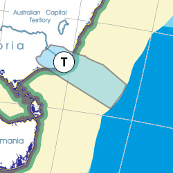
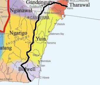
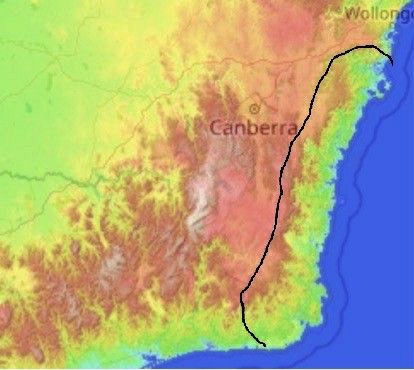
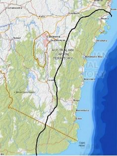
Hotspot 36 - Cape Howe region (T) topography. Hotspot boundary based on the flow of water FOW (for good reasons). Boundary starts at sea just below Kiama directly in/up towards Goulburn to TOR, then down along TOR to encompass Cann River, then to the sea. Includes Gerringong, Berry, Nowra, Ulladulla, Batemans Bay, Narooma, Bega, Merimbula, Eden, etc.
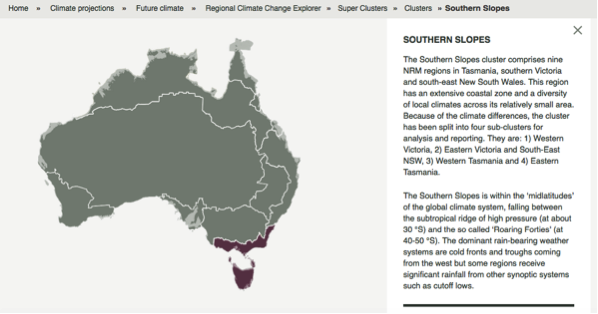
Other regional projections - CSIRO part of Southern Slopes region
The CSIRO has regions for projecting the impact of Climate Change. See https://www.climatechangeinaustralia.gov.au/en/climate-projections/futur... This state, Cape Howe State (T), is one of the clear projections in a CSIRO cluster called "Southern Slopes region". CSIRO's Southern Slopes region coincides exactly with BloggerMe's T,O,U,V,W.
Nuclear weapons
Centre ground zero CGZ - Merimbula - 475 kilotons (431 kilotonnes)
https://nuclearsecrecy.com/nukemap/

Click here to:
Comments
Steve Irons
Thu, 01/10/2020 - 2:42pm
Permalink
Beauty
Camel Rock, Bermagui
https://www.pinterest.com/pin/418553359093991538/
Blue Pool Camel Rock
https://www.pinterest.com/pin/418553359093933277/
Emu Flat, south of Braidwood
https://www.pinterest.com/pin/418553359095114896/
Mulligans Flat
https://www.pinterest.com/pin/418553359095303317/
Twitter
Sat, 29/12/2012 - 8:28am
Permalink
Eden
Meredith Stanton @CloudsCreek
Anti-forestry campaigner disappointed about chip mill future http://www.abc.net.au/news/2012-12-27/mill-future-reax/4444360 …
Twitter
Sat, 24/11/2012 - 7:52pm
Permalink
Snowy Hydro SouthCare
SnowyHydroSouthCare @SHSCHelicopter
Snowy Hydro SouthCare: tasked to BEGA hospital on a secondary mission, medical transfer to The Canberra hospital.
Twitter
Thu, 22/11/2012 - 8:26am
Permalink
Batemans Bay
CSIRO @CSIROnews
Pics: Former CSIRO cloud physicist Ron Cottis snapped these awesome shots of a waterspout at Batemans Bay http://ow.ly/fslYl
Twitter
Fri, 02/11/2012 - 12:34pm
Permalink
Biodiversity projects
Bega District News @Bega_News
In the BDN today – Biodiversity projects to protect #koalas well underway in #Bega Valley @mikekellymp http://ow.ly/eXmva
Twitter
Fri, 02/11/2012 - 12:32pm
Permalink
Bermagui’s little artists
Bega District News @Bega_News
In the BDN today – Something to Crow About: #Bermagui’s little artists putting on a big exhibition http://ow.ly/eMdFi
Add new comment