|
Capital: |
Carnarvon 5283 |
|
Others: |
Exmouth 1,844 Denham 607 Barrow Island uninhabited Cocos-Keeling Islands 600 |
|
Super region: |
|
| Hospital: | http://www.health.wa.gov.au/services/detail.cfm?Unit_ID=64 |
|
University: |
|
| Airport: | http://en.wikipedia.org/wiki/Carnarvon_Airport_%28Australia%29 |
|
Basin Authority: |
Gascoyne Basin Authority (GBA)
Coal Gas (Offshore) http://www.sbs.com.au/news/article/1626037 http://www.bom.gov.au/wa/carnarvon/ http://www.bom.gov.au/wa/cocos_island/ http://www.bom.gov.au/wa/learmonth/ State Pin
|
Thanks for checking this Region out.
This Region is prepared on the a-political concept that if you are interested in 'place' in Australia, the most important aspect that defines 'place', is the 'flow of water'. The Senate is interested in 'place'.
This Region defines its boundaries at the top of the ridge, where water flows one way rather than the other. This leads to a very interesting 'place'.
We are seeking a debate with people who live in this proposed new Region. We know we've got the Region pretty well correct; after all, it's just geography. But if you live in this Region you can tell us a lot of interesting things.
- Do these boundaries define a place that is unique; different to every other Region in Australia? We think that that is probably quite likely.
- Is it a great place, worthy of recognition?
- Upon formation, what should be the name of this Region? Who would be the Lord Mayor? Who would be the two Senators who represent this Region? Who would be the additional Senator that represents the interests of Aboriginal & Torres Strait Islander peoples in this region? What benefit would there be in seeing the island as a super region known as Pilbara?
- Would life be enhanced if it was on a fast Ring-Rail that links the Capital City to every other Capital City around Australia?
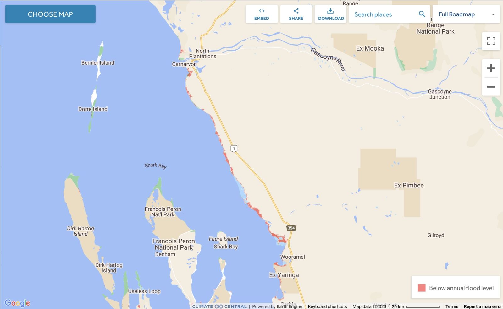
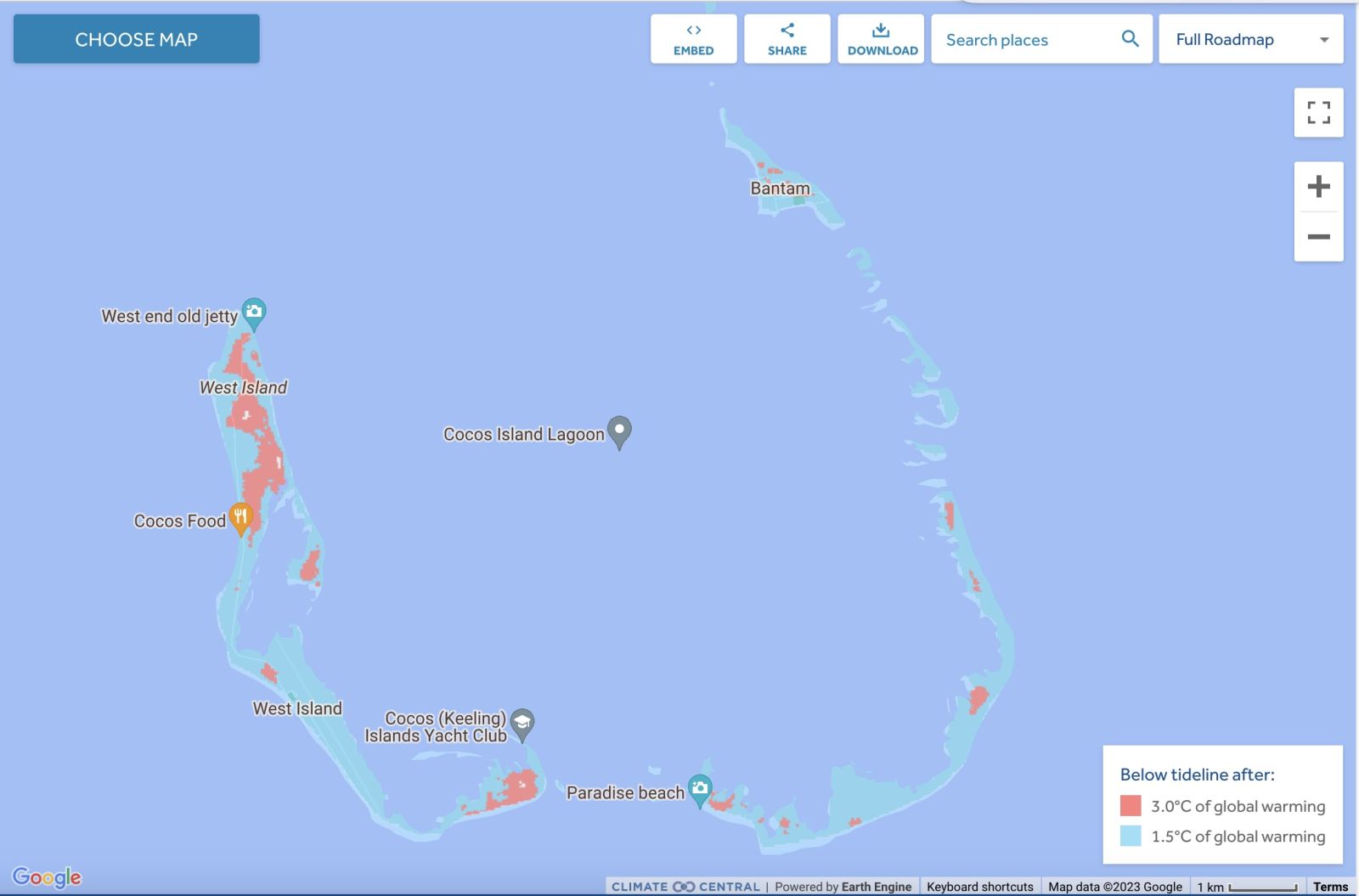
Land projected to be below annual flood level in 2050
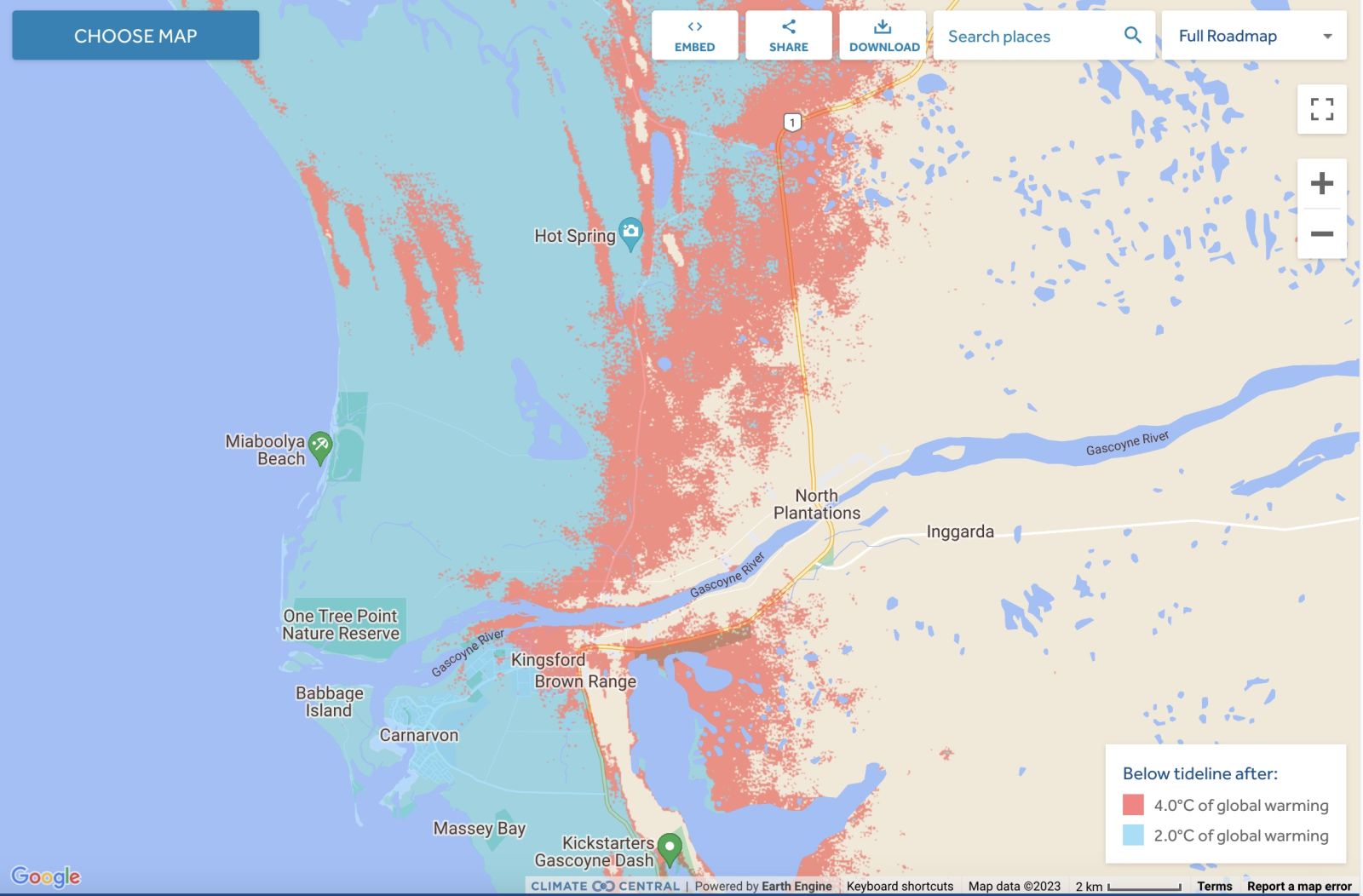
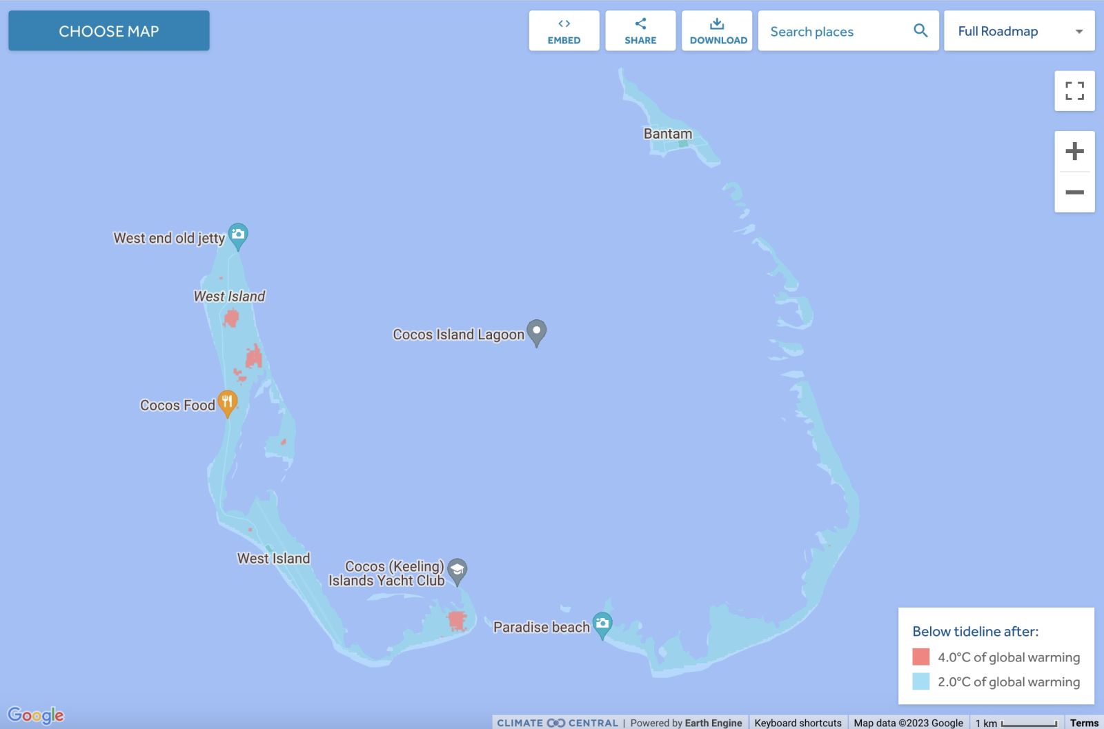
Comparison: long-term sea level outcomes
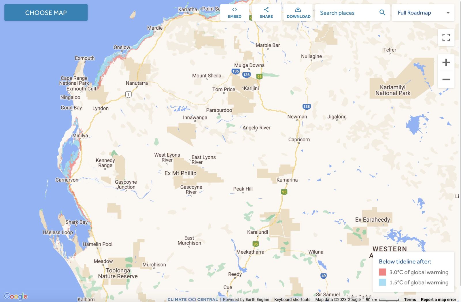
Comparison: long-term sea level outcomes
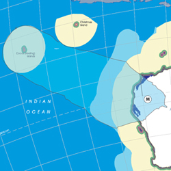
Kokos Keeling Islands - Land projected to be below annual flood level in 2050
.jpeg)
Kokos Keeling Islands - Comparison: long-term sea level outcomes
Kokos Keeling Islands - Comparison: long-term sea level outcomes
|
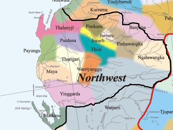
Aboriginal Australia:
|
|
|
NOTE1: Likely indicators only; for original Aboriginal Australia Map © 1991 & restrictions on its copy & use, see Aboriginal Australia Map NOTE2: The red line is part of the original Aboriginal Australia Map © 1991. The black line is added by Bloggerme for discussion only. It shows the likely State boundary based on the flow of water only. As "the ridge" (See FOWTOR) naturally impacts on the development of the language, social or nation groups of the Indigenous people of Australia, the proposed border is often identical to the group boundary shown on the Aboriginal Australia Map. This is as was expected. Variations are social/historical & result in a particular language, social or nation group being represented in two adjoining States. |
|
|
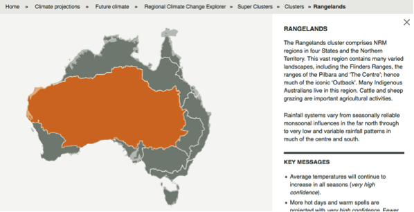
Other regional projections - CSIRO part of Rangelands regionThe CSIRO has regions for projecting the impact of Climate Change. See https://www.climatechangeinaustralia.gov.au/en/climate-projections/futur... This state, Murujuga State (M), is one of the clear projections in a CSIRO cluster called "Rangelands region". CSIRO's Rangelands region coincides with BloggerMe's L,M,X (missing a tiny bit), R (missing a tiny bit), but includes a large bit of S (the Darling River bit). |
Other regional projections - NMR - part of Rangelands WA NRM
See http://nrmregionsaustralia.com.au/nrm-regions-map/
See http://nrmregionsaustralia.com.au/Rangelands-NRM-Coordinating-Group-Inc./
Gulf Savanna Region https://rangelandswa.com.au/
Nuclear weapons
Centre ground zero CGZ - Carnarvon - 475 kilotons (431 kilotonnes)
https://nuclearsecrecy.com/nukemap/
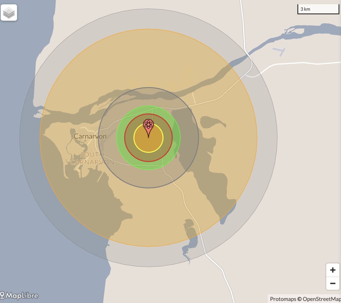
NB: population 10km around Carnarvon CBD LEGEND
https://australia.places-in-the-world.com/12069995-places-within-10km-ar...
Population taken out by nuclear weapon = 5,983
Click here to:
Comments
Steve Irons
Thu, 08/10/2020 - 2:46pm
Permalink
Beauty
Shell Beach, Shark Bay
https://www.pinterest.com/pin/418553359093990049/
Shell Beach, Francois Peron National Park
https://www.pinterest.com/pin/418553359094207887/
Monkey Mia
https://www.pinterest.com/pin/418553359094272829/
Karijini National Park
https://www.pinterest.com/pin/418553359094434024/
Karijini National Park
https://www.pinterest.com/pin/418553359094053993/
Coral Bay
https://www.pinterest.com/pin/418553359094492140/
Wittecarra Gully, Kalbarri National Park
https://www.pinterest.com/pin/418553359095477514/
Shark Bay
https://www.pinterest.com/pin/418553359097845226/
Ningaloo Reef
https://www.pinterest.com/pin/418553359098539404/
Karijini National Park
https://www.pinterest.com/pin/418553359098539493/
Shark Bay
https://www.pinterest.com/pin/418553359098539412/
Steve Irons
Fri, 13/03/2015 - 12:32pm
Permalink
TC-Olwyn hits land
TC-Olwyn hits land at Exmouth level 3. Now over Coral Bay heading for Geraldton.
http://www.abc.net.au/news/emergency/
See http://www.bom.gov.au/cyclone/about/warnings/
Steve Irons
Wed, 11/03/2015 - 2:36pm
Permalink
Cyclone heading for Exmouth
TC-Olwyn, a cyclone part of a multiple cyclone system including Cyclone Nathan heading towards Cape Flattery & Cooktown & Cyclone Pam over Vanuatu, is heading towards Exmounth. @ABCemergency 3m3 minutes ago pic.twitter.com/BkFpyocUQP
https://www.facebook.com/ABCweatherandemergency/posts/403916269789143
Cyclone warnings for #Qld (Coen - Cape Trib) + #WA (inc Karatha + Exmouth). #CycloneNathan
See http://www.bom.gov.au/cyclone/about/warnings/
Steve Irons
Thu, 25/12/2014 - 10:51pm
Permalink
Cocos Island Tropical cyclone Kate
Cocos Update: Cocos Islands buffeted by strong winds as Tropical Cyclone Kate passes north http://ab.co/1JRyCLA #TCKate https://twitter.com/abcnews/status/548079938243293188/photo/1
Twitter
Mon, 25/02/2013 - 4:30pm
Permalink
Pilbara
ILC UNSW @ILC_UNSW
Aboriginal contracting gp Eastern Guruma & Wirlu-murra Yindjibarndi Aboriginal Corp win $200 mill contract in Pilbara http://www.wabusinessnews.com.au/article/Aboriginal-contractors-win-200m-FMG-deal …
Twitter
Fri, 04/01/2013 - 4:28am
Permalink
Gorgon Project
Meredith Stanton @CloudsCreek
#Australia: Coal Seam Gas Faces Tax Bill Of Billions http://www.theage.com.au/business/coal-seam-gas-faces-tax-bill-of-billions-20121118-29k6t.html … …
Twitter
Mon, 26/11/2012 - 6:22am
Permalink
native title agreement in Pilbara
ILC UNSW @ILC_UNSW
A native title agreement in Pilbara includes payments for miners' use of water; a first for region & the state http://www.abc.net.au/rural/news/content/201211/s3638226.htm?§ion=latest&date=(none …)
Twitter
Wed, 31/10/2012 - 1:51pm
Permalink
Barrow Island threat
Ben Cubby @bencubby
Scientists build system for tracking hitchhiking geckos at gas field. http://bit.ly/T3pTKb
Twitter
Wed, 31/10/2012 - 1:11pm
Permalink
Homelessness in Carnarvon
Homelessness Aus @HomelessnessAus
New report released @AHURI_Research: Indigenous house crowding http://bit.ly/RrKGsy New ABS def found nearly 30% of h'less pop is Indigenous
Twitter
Fri, 26/10/2012 - 1:33am
Permalink
Solar power & its effect on the infrastructure
CSIRO @CSIROnews
We're currently bidding to better understand solar power flow in Aus http://ow.ly/eIeWj via @SMH
Steve Irons
Thu, 18/10/2012 - 4:11am
Permalink
Rough Draft
Steve Irons
Sat, 13/10/2012 - 4:29am
Permalink
A local in the Pilbara
http://instagram.com/p/Qq-J9ZwFTT/
Add new comment