Submitted by Steve Irons on Sat, 25/07/2015 - 10:24am
Change of State Boundaries - Really?
Again we have talk of new States in Australia, as key people in the Northern Territory raise arguments for statehood.
- http://www.smh.com.au/federal-politics/political-news/northern-territory...
- http://www.abc.net.au/news/2015-07-23/fourteen-names-for-the-northern-te...
- http://www.abc.net.au/news/2015-07-23/leaders-back-prospect-of-creating-...
- http://www.ntnews.com.au/news/northern-territory/northern-territory-coul...
This issue will never go away!
It will never go away because the state boundaries of Australia were out of date before Federation in 1901. The gutless governors in the late 1800s were playing to the tune of British colonialism, and would do anything to make sure there was no serious argument between them, that might somehow stir up a real fight for independence, as we had seen in the previous century where the British had their arses kicked by the emerging United States of America.
So the boundaries between the States in Australia are totally meaningless today. They represent power and privilege extant in the late 1800s. They are mostly drawn with a ruler and a pen, totally mindless (with the exception of most of the boundary between NSW and Victoria) of anything happening on the ground.
So, if we are serious about statehood in the Northern Territory, let's start to get it right this time.
We need change in statehood in Australia.
It is long overdue.
But we don't just need a new point to a pathetic star on a British colonialist flag, a flag that has passed its useby date. We don't just need to change the name of the "Northern Territory" to the "State of the Northern Territory", or something equally banale. We need real change. Here are some Ideas on what changes should be considered in the Northern Territory; changes that , if done correctly, have the potential to bring about fundamental change in the rest of Australia, as well.
Not One, But Eight
We don't need a mindless change in names, with little or no change to the rules that govern life in the Territory; a change that will waste millions of dollars to perform, and have little, if any, serious impact on the lives of Territorians.
No, we don't need one new State; we actually need eight.
Why Eight?
We need eight, because if we are going to introduce new boundaries to the borders of the States, the best thing we can use to determine these boundaries is the flow of water. Water is the most important factor that impacts on life in an arid desert-dominated environment. As we have seen in the Murray-Darling complex, we ignore the flow of water at our peril. If we ignore the flow of water, we can call into question our very existence on this planet!
Modelling: If you got Australia's best geography thinkers, geologists, environmentalists and landuse experts to get together and draw some boundaries in the vicinity of the Territory, based on the flow of water, they would come up with something like this:
Note: this model is taken from the FOWTOR model See the full model for the whole of Australia at http://www.bloggerme.com.au/
For explanation of FOWTOR modelling See http://www.bloggerme.com.au/fowtor-model-dont-laugh-im-serious
|
|
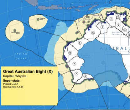
This State is Great Australian Bight Capital: Whyalla Needs the cooperation of the Federal government Western Australia and South Australia in its formation Water flows into the Southern Ocean Read more on this State:
|
|
|
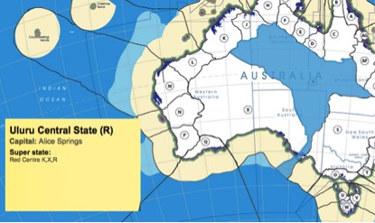
This State is Uluru Central Capital: Alice Springs Needs the cooperation of the Federal government, Western Australia, South Australia, Queensland, and New South Wales in its formation Water flows into the Southern Ocean Read more on this State: |
|
|
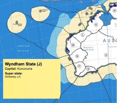
This State is Wyndham Capital: Kununurra Needs the cooperation of the Federal government and Western Australia in its formation Water flows into the Timor Sea Read more on this State:
|
|
|
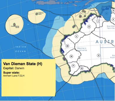
This State is Van Dieman Capital: Darwin Needs the cooperation of the Federal government in its formation Water flows into the Timor Sea Read more on this State: |
|
|
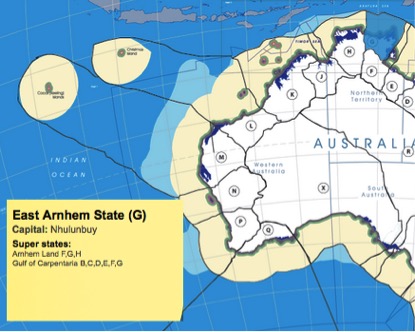
This State is East Arnhem Capital: Nhulunbuy Needs the cooperation of the Federal government in its formation Water flows into the Arafura Sea Read more on this State: |
|
|
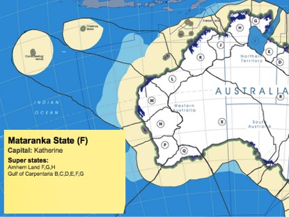
This State is Mataranka Capital: Katherine Needs the cooperation of the Federal government in its formation Water flows into the Gulf Read more on this State: |
|
|
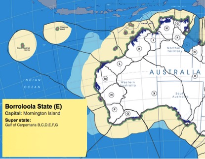
This State is Borroloola Capital: Mornington Island Needs the cooperation of the Federal government in its formation Water flows into the Gulf Read more on this State: |
|
|
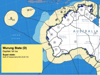
This State is Wurung Capital: Mt Isa Needs the cooperation of the Federal government and Queensland in its formation Water flows into the Gulf Read more on this State: |
Won't this mean we will be over-governed? All these States?
At present each of these capitals exists, they already govern. Their local government responsibilities finish at the boundary of the city/town. But their responsibilities at present have little to do with the flow of water, little or nothing to do with the sea into which the water flows, so anything dramatic that affects the lives of the people living under their jurisdiction, apart from water mains and sanitation and garbage collection, have to be imposed on them from above. This plan abolishs the local government boundaries (which has no Constitutional basis and is suffering from a failure to resolve a constitutional crisis) and replaces them with real boundararies that give them control over the lives of those that they govern, from the dropping of the water from the sky to its dropping of silt on the shelf, as the water flows out to sea. It includes the environment, development, mining, pollution, fishing, protection, heritage, policing, etc. Because we are abolishing the Territory, and abolishing the local government boundaries, the cost of governance is not expected to be significantly different to what it is today. The impact on the lives of the electors is, however, expected to be significant.
What about Senators?
The plan outlined here is taken from a model to draw the boundaries based on the flow of water all around Australia.
This model suggests 2 Senators per State and results in exactly the same number of Senators as we have at present. The only difference is, the Senators, rather than being responsible for a meaningless straight line drawn on a map by competing governors in the late 1800s, purely a way of assigning power to politicians, are now responsible for meaningful boundaries, affecting the lives of particular people within those easily understood boundaries.
So these changes, if they are to happen in the Northern Territory, should also happen everywhere else around Australia. The Senators would then have a clear understanding of their responsibilities and who they are respresenting when they carry out the role as reviewers of policy initiatives coming from the House of Representatives.
Indigenous & Torres Strait Islander Peoples
Each of these boundaries has been mapped against the traditional boundaries of language, social or nation groups of Indigenous Australia at http://www.bloggerme.com.au/aboriginal-australia-map1 This map can also be seen at http://www.abc.net.au/indigenous/map/
While the boundaries don't always coincide, the similarities are exceptional and the differences are less than you would expect. This probably has to do with the importance of the flow of water in the history of boundaries of language, social or nation groups. To check the coincidence and differences, check each map here:
- http://www.bloggerme.com.au/states/great-australian-bight
- http://www.bloggerme.com.au/states/ulluru-central
- http://www.bloggerme.com.au/states/wyndham
- http://www.bloggerme.com.au/states/van-dieman
- http://www.bloggerme.com.au/states/east-arnhem
- http://www.bloggerme.com.au/states/mataranka
- http://www.bloggerme.com.au/states/borroloola
- http://www.bloggerme.com.au/states/wurung
If we are going to start a new process related to State boundaries, let's make it a meaningful discussion, this time.
Steve Irons - 25 July 2015
Comments
Shirley Green
Mon, 27/07/2015 - 3:32pm
Permalink
State boundaries
This is interesting Steve but I think it will be a very long time for their to be any changes. I don't think there is sufficient impetus. However, if there are to be changes, debate must continue.
Matt Mitchell
Sun, 26/07/2015 - 6:55pm
Permalink
State Boundaries
Yes, Steve perhaps this is a good opporunity to raise this debate again. There is considerable dissatisfaction across Australia with local governments (ie councils) which had led to implemention of limits on rate rises by higher levels of governments.
Perhaps we should replace local governments with a proper parliamentary model and in the process remove the troublesome problem of taxation through property rates and replace them instead with a percentage of GST or income tax. This would link taxes to income and spending rather than the current model which risks seeing - and sometimes does see - people eveited from their homes because they cannot pay rates.
Add new comment