Submitted by Steve Irons on Fri, 13/03/2020 - 2:44pm
Introduction
This paper seeks to take a look at an important work on international frontiers and boundaries, a legal, political and geographical undertaking published by Victor Prescott & Gillian D. Triggs 20081, with a view to providing a more rigorous nomenclature for describing the FOWTOR model (2008) presented on this platform. I was unaware of this book's existence until the other day, when I came across it by accident, looking as I was at Gillian's various achievements over the years. But the book spoke immediately and directly to my interests and concerns, not on an international level (so much) but on a national and regional level, and helped me put my nomenclature into perspective. I immediatly started to compare their work with mine and found the comparison compelling. I got many of the concepts expressed in their work correct, few need to be re-written, but the completeness of their description of borders, frontiers and boundaries gives an added perspective that I thought will help readers understand where I am coming from in developing the FOWTOR model.
1. Victor Prescott and Gillian D. Triggs: International Frontiers and Boundaries: Law, Politics and Geography (Martinus NijHoff Publishers, Leiden Boston, 2008) 517pp. (P&T, 2008)
2. https://geography.unimelb.edu.au/news/vale-professor-emeritus-victor-prescott
Synopsis
Territory in the land we now, since 1901, call Australia, has always, since traditional times, been defined by boundary, on land and at sea. The map of traditional 'nations' (called that by current traditional descendants) places that clearly on the historical record. Borders are assumed to have played an enormous role in pre-'settlement' social life. Frontiers are assumed to have not.
Of course, at the beginning of colonisation, colonies weren't defined by boundary. A 'settlement' was surrounded by a frontier, which defined the original movement of British 'settlers' into the continent. The lack of boundary in the eyes, the maps, the legal infrastructure, etc. of the 'settlers' just indicated a lack of knowledge of the the continent they were engaged in oppressing and changing, over time, as they moved in and took control. Borders played no role in this incursion and takeover.
Once they had occupied the whole continent, the colonial governors set about drawing up State boundaries. These were what in international circles are called ‘superimposed’ boundaries. Their purpose was to establish 'properly defined' Statehood. They said that they were drawing ‘pioneer’ boundaries. But that was a lie, because the colonialists just denied any existence of antecedent boundaries. The 'settlers' saw the whole continent as 'unpopulated'. This was a lie, too, and it led to genocide. Establishing the truth of the lie, ex post facto. Genocide of existing owners of the nations played a huge role in takeover and occupation. New state boundaries extended the genocide. Their purpose was an imposed 'legitimacy' to be approved by the English monarchy.
If they had recognised antecedent boundaries they would have been involved in ‘imposing’ subsequent boundaries (with agreement) or ‘superimposing’ subsequent boundaries (on discordant populations). In either case a treaty would have been ‘seen’ as necessary. After 'occupation' and drawing their boundaries the colonialists engaged in allocation, delimitation, demarcation, and administration of boundaries and creating borders between States. The existing Indigenous population saw it as superimposition. Their allocation, delimitation, demarcation, and administration, that had gone on for thousands of years, by existing nations, had been wiped from the historical record.
Aboriginal & Torres Strait Islander communities see ‘ownership’ as a pejorative term, both ways. As there has never been a treaty, ownership has never been ceded and is treated with contempt and disapproval by many traditional communities.
The ‘straight line’ (arbitrary) boundaries drawn up by the governors and agreed upon as late as 1901 were in the main purely political and meaningless in practice. The paper goes into some of the absurdities that they (regionalism vs statehood) have thrown up, like’’
· complete lack of democracy for Indigenous populations, until 1967,
· lack of human rights for Aboriginal and Torres Strait Islander communities and reasons why,
· continuation under Intervention and reasons why,
· drinking hours,
· fruitfly control,
· other quarantining laws,
· arbitrary sub-division of towns down the Murray,
· single town populations living under different state laws on either side of the river,
· complete lack of State focus on control of the major river system Murray-Darling,
· no duty of care for Indigenous populations,
· State politicians from 5 states, their administrators, and their capitalist buddies taking part in misappropriation and rorting of MDBA resources and water resources for personal financial and political benefits,
· privatisation of essential water runoff and supplies,
· selling water for agricultural and industrial use to the highest bidder via ripoff international capitalist theft and exploitation,
· leaving agriculturalist use and the natural character of the river and the natural life contained in the river without enough water to survive.
· selling water internationally from the most arid continent on the planet,
· damaging key water resources such as The Great Artesian Basin,
· redirecting essential water resources for free to capitalist mining companies and cotton growing for largesse and political purpose.
The list of misdirected and fraudulent behaviour by both levels of government, State and Federal, goes on and on.
The paper also discusses the ownership by the national government of the territories, the absurdities and how that has changed over time. Ownership and control have been a complete failure. As a result, the territories have metamorphosised into States. But with unplanned consequences.
Trying to fix these absurdities brings in new absurdities (such as the failure to introduce Constitutional change (third tier), and (unconstitutional) City Deals which are political and abitrary introducing largesse and payback). The impact of these failures on their populations continue. Time for real change.
The paper introduces, intertwined in this discussion of borders, frontiers and boundaries, a new regionalism called FOWTOR. It draws consequential state boundaries based on the Flow Of Water (FOW). Each boundary is found at the Top Of Ridge (TOR) for each new state (region) and includes maritime boundaries. This results in meaningful communities and meaningful border crossings both on land and at sea, taking out the absurdities of existing arbitrary State boundaries. It discusses new FOWTOR state boundaries both land and sea and their relationship to international maritime boundaries Australia has with other countries both to the North, North West, North East and to the South. It discusses border crossings land and sea. It discusses their impact on key issues borders impose on state (regional) life, and on state development, past, present, and future.
Terminology of Boundary, Frontier, and Border
Introduction
| FOWTOR Model | International |
|
Territory in the land we now, since 1901, call Australia, has always, since traditional times, been defined by boundary, on land and at sea. The map of traditional 'nations' (called that by current traditional descendants) places that clearly on the historical record. https://www.bloggerme.com.au/aboriginal-australia-map1 Borders are assumed to have played an enormous role in pre-'settlement' social life. Of course, at the beginning of colonisation, colonies weren't defined by boundary. A 'settlement' was surrounded by a frontier, which defined the original movement of British 'settlers' into the continent. The lack of boundary in the eyes, the maps, the legal infrastructure, etc. of the 'settlers' just indicated a lack of knowledge of the character of the continent they were engaged in oppressing and changing, over time, as they moved in and took control. Borders played no role in this incursion and takeover. |
The Paris and Chicago Conventions defined territory as all land and territorial waters. P&T(2008). p.15 The terms boundary, frontier and border are often used as synonyms in conversation, in newspaper reports and in television and radio broadcasts. For boundary scholars they are all specific terms that are not interchangeable, and there are other terms that have precise meanings. P&T(2008). p11 |
Boundary, frontier, border
| FOWTOR Model | International |
|
In the FOWTOR model, A boundary is a line while a frontier and a border are different kinds of areas. |
A boundary is a line while a frontier and a border are different kinds of areas. P&T(2008). p.12 |
|
In the FOWTOR model, whether we call them 'states' or 'regions' (which is just a naming convention used across the world to define a particular type of territory) all (territories) are defined by a boundary both on land and at sea, inclusive. In the following description of boundaries, frontiers and borders, the territories (states or regions) shall be called states for good reason. It makes the description more readable, but it also implies that FOWTOR is achievable with good intentions on all sides of the discourse, under the existing Constitution. But, having said that, FOWTOR is a proposed regional convention for good reason, which will become clear. The states described in the FOWTOR model are defined by three types of boundary: (a) state boundary on land; (b) state maritime boundary; and (c) state maritime boundary coinciding with an acceptable national maritime boundary (See below). The frontiers continued from each landing point where governors controlled the complete takeover and occupation. Once the continent was fully 'occupied'3 by the British, the colonies began to define their 'ownership'4 (control) by introducing colonial boundaries. These boundaries, being purely political and only useful in the play for power, prestige and influence of the governors of the various colonies with their majesty back in England, kept changing, as those influences changed. They were only fully decided upon, with a permanency, never to be changed (in the minds of the governors of the States signing off on the Constitution, at least, although the Constitution 1901 does allow such alteration), at federation, 1901. After 1901 they became known as state boundaries. People saw them as state borders, because they were informed of their leaving one state and entry into another, at the border. They also saw them as largely jurisdictional, such as drinking laws in Victoria meant you needed to drink faster than if you were in a pub in New South Wales. Sometimes this was somewhat farcical in the minds of the ordinary drinkers because they knew the fruitfly had little knowledge that they had crossed the border at the Murray at Echuca, despite strict quarantining restrictions at the border. The quarantining laws of the states were usually regional in character and went against the arbitrary boundaries drawn up in the 19th century. They still do: https://www.interstatequarantine.org.au/travellers/quarantine-zones/ ___________________ 3: 'occupation' is clear and meaningful in the international historical discourse engaged in analysing control of territory, around the world, over time, and is usually associated with such terms as superimposed, discordant, see below. 4: 'ownership' is on the record of Aboriginal & Torres Strait Islander communities as a perjorative term, both ways. As there has never been a treaty, ownership has never been ceded and is treated with contempt and disapproval by many traditional communities.
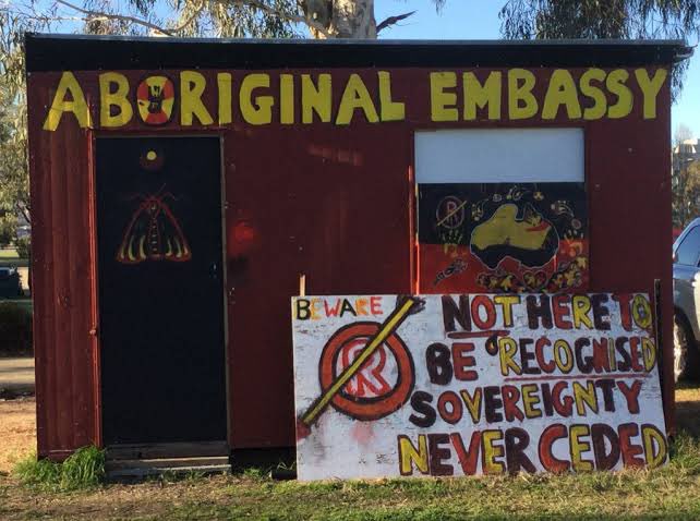
Aboriginal Embassy - @blakandblack https://twitter.com/BlakandBlack/status/1250539732158709760 |
Frontier
| FOWTOR Model | International |
|
In the FOWTOR model, the term frontier has two meanings: The first meaning has to do with original ownership of the continent prior to 'settlement'. The map provided by Indigenous descendants https://www.bloggerme.com.au/aboriginal-australia-map1 suggests that the whole of the continent was populated and divided up by boundaries on land and, for those territories along the coast, boundaries on land and at sea. Assuming those boundaries were agreed boundaries, agreed by social communities living alongside each other, there are no frontiers. Of course, if there was disagreement about the meaning and location of the boundary for any nation, there could be political frontier(s) if, for example, that disagreement led to formal armed incursions by one nation across the disputed 'border' into another. As history progresses, more will be available on this subject. A frontier might also be used to define a territory within a nation if certain members of the social community remove themselves or are expelled from the community and go / are sent off to 'fend for themselves'. This could be called 'outlawing', as it means they are 'outside' the 'laws' of the social network of the community. The second meaning of frontier refers to the 'settlement' frontiers of the colonies, around the continent. This frontier is only an idea in the mind of the British political elite conducting 'settlement'. It represents the distinction (by them) between land occupied and controlled by the colonists and land yet unoccupied and uncontrolled (by the colonists). The 'settlers' saw the whole continent as 'unpopulated'. We now know that that was just a lie in the minds of the political leaders engaged in using those under their command to bring the whole continent under the control of the colonialists. We know it to be a lie, because of the mass killings of Indigenous populations and the coverup of those killings in the official historical record of 'settlement'. |
The term frontier has two meanings. Long ago political frontiers separated tribes or kingdoms or principalities Waldron, A., 1990. The Great Wall of China: from history to myth, Cambridge University Press: Cambridge. |
Border, Borderland
| FOWTOR Model | International |
|
In the FOWTOR model, the terms border and borderland are synonyms. They are both zones of indeterminate width that form the outermost parts of a state that are bounded on each side by the boundary of those states, with adjacent states. They can be considered borderland and bordersea, that is to say: (a) on state land adjacent to another state at the state's boundary, and (b) on sea adjacent to another state at the state maritime boundary, up to the national maritime boundary at Australia's Exclusive Economic Zone Limit (chosen because it is recognised internationally as separating the nation state (the state controlled by the federal government) of Australia from international water commonly referred to as the high seas). Climbing up the hill to the TOR and sailing out to sea (port or starboard) until we come into contact with our state's maritime boundary and (afore) until we reach the national maritime boundary line at Australia's Exclusive Economic Zone Limit, these borders define a state zone with the state fully in charge of le voisinage, meaning (in international nomenclature): 'our neighbourhood, in our vicinity, determined by nearness, our neighbours, with whom we have, we seek to have, good neighbourly relations', relevant to our FOWTOR state's interaction with adjacent states. This le voisinage concept is a key concept for understanding why we are promoting FOWTOR. Le voisinage can only be carried out at the 'state' level (here we mean state as defined under our FOWTOR model, not current State boundaries, for good reasons) or 'community' level (combine the two and you start to understand the meaning of the word 'regional'). Le voisinage roles and responsibilities and benefits is necessarily shared in our state with adjacent states, at the border. |
The terms border and borderland are synonyms. They are both zones of indeterminate width that form the outermost parts of a country, that are bounded on one side by the national boundary. Lapradelle called such zones le voisinage, meaning neighbourhood, vicinity, nearness, neighbours. He also uses the term le territoire limitrophe translated as the neighbouring or bordering area. P&T(2008). p.12 Lapradelle, P. de, 1928. La frontière: etude de droit international [The boundary: a study of international law], Les Éditions Internationales: Paris. This historical surge in drawing boundaries on land has been matched since the 1940s by what Eckert (1979) has called ‘The enclosure of the oceans’. Since 1947 countries have claimed waters and seabed within 200 nautical miles of their coasts. In some cases claims to the seabed extend beyond this limit. P&T(2008). p.13 Ekert, R.D., 1979. The enclosure of the oceans, Hoover Press: Stanford.
|
Land Boundaries, Borderland - State & Local
| FOWTOR Model | International |
|
In the past, State governments have, mainly since the middle of the C19th, written certain aspects of le voisinage into their mandate, with limited and varying success. They have often left it to local government to take up the black holes left in their performance. This failure is due mainly to State governments around the continent concentrating their focus on the big end of town in the major cities, leaving those in the countryside to 'fend for themselves'. Unless, for example, they were called in to clean up the mess that this lack of due focus created. Local government has taken up these requirements with limited and varying success. Boundary and borderland has often played a role in determining the success or otherwise of these varying performances. Because the State boundaries have been so arbitrary, political, and meaningless to le voisinage between communities, any so-called borderland has in the main part also been arbitrary and meaningless. See, for example, the list of bordertowns along the Murray: http://www.murrayriver.com.au/river-towns/murray-river-towns/ And where this lack of focus on borderland was meaningful, it could even be damaging to le voisinage. For example the boundaries between NSW, and Victoria, determined mostly by the most important flowing river in Australia, set up a boundary of meaningless nonsense, that had huge implication on the communities that it flowed through. It divided the borderlands going down the river into two arbitrary sub-divisions. Towns naturally formed on the river because they needed the water that it provided to survive. But communities living on either side of the river lived under different State laws and jurisdictions. Borderlands were therefore mostly arbitrary and meaningless. And it meant that the focus of the States was completely missing when it came to the management of the river. Local governments, whose boundary was mostly set at the 'edge of town' on either side of the river, saw the water coming in 'from somewhere' and mostly saw the water going 'to somewhere, who cares, let it be a drain or a sewer'. A lot of this nonsensical relationship of local government with the river had to do with boundary. The nonsense of the boundary of towns around Australia being the edge of the conurbation, made little sense to anything that needed to be performed in that town, such as in the surrounding district, such as existing traditional Aboriginal communities, and especially in relation to the river. Towns were not significantly just conurbation. They were there for regional purpose. But you wouldn't know that if you sat in on council considerations. The limited town boundary ideas removed focus away from le voisinage to political power structures that mainly concerned themselves with power, prestige, and the ownership, purchase, sale and profit of real estate. The problem with the River Murray only started to be addressed when it reached crisis point and it became obvious that a state as described in FOWTOR was needed to clean up the mess. In 2012 the Murray Darling Basin Authority MDBA was established bringing in (in addition to the NSW & Victoria rivers and their tributaries) the States of Queensland (tributaries) and South Australia (downstream and outflow) and in part The Australian Capital Territory (upper Murray Murrumbidgee etc.) into the picture.
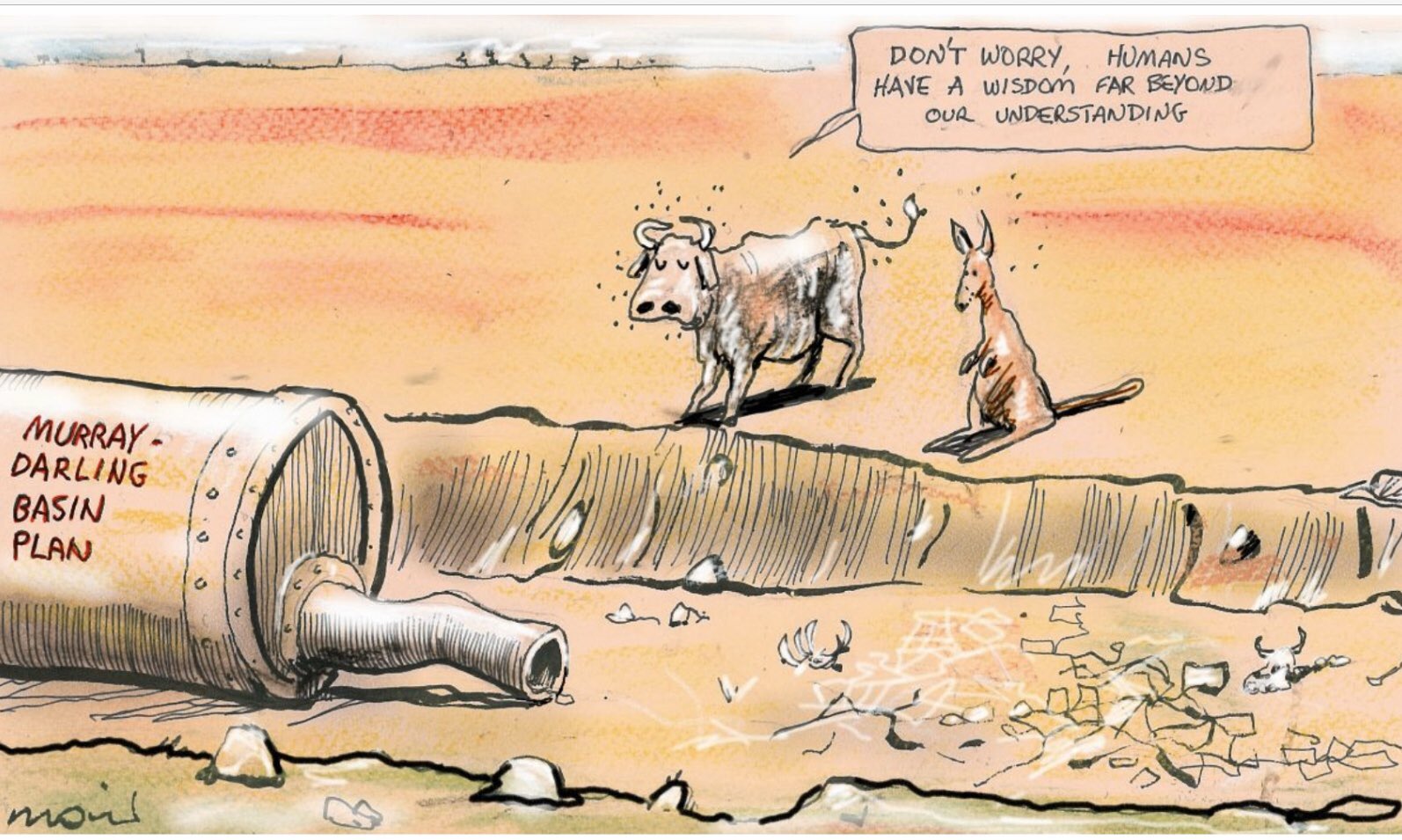
Alan Moir - "Don't worry ..." The MDBA was drawn up 5 years after FOWTOR was presented to Parliament. MDBA (2012) defined a 'region' based on the FOW which turned out to be exactly the same as the state described by FOWTOR (2007) (proving without any doubt the importance of FOWTOR's 'regionalism' to le voisinage). But this 'region' under MDBA is a description without the legal profile / jurisdiction needed to carry out its responsibilities, still beholden to the money coming from the State governments, that is to say, decisions being dictated by capitalist financiers in the cities, do things this way or you will not get the funds. This was proven clearly by State politicians, their administrators, and their capitalist buddies taking part in misappropriation and rorting of MDBA resources and water resources for personal financial and political benefits, most of which went unnoticed or only opposed by community speakers unheard in the main, and claims of which are still being investigated, as we speak. Anyway, by the time MDBA was properly functional it was too late. Privatisation had taken over and vested interests were coming in for the kill to steal as much of the life of the river that they could get for themselves. This could only happen because of the focus of State governments and their vested interests in the city. A FOWTOR state with its focus on the river would to a large extent remove those vested interests. The tributaries in Queensland calling the shots for river usage further downstream and allowing the huge capitalist cotton growers to steal all the tributary river water (calling it personal capture and storage) would not happen without a big punch up under FOWTOR. And FOWTOR creates a state with the power to implement the changes required. MDBA, beholden to State power in the various cities, in 5 State governments, will never have that power. (Note: On land, in general terms, they have even at both the state and federal level moved Australia to privatisation of essential water runoff and supplies, to selling water for agricultural and industrial use to the highest bidder via ripoff international capitalist theft and exploitation, to leaving agriculturalist use and the natural character of the river and the natural life contained in the river without enough water to survive, to selling water internationally from the most arid continent on the planet, to damaging key water resources such as The Great Artesian Basin, to redirecting essential water resources for free to capitalist mining companies and cotton growing for largesse and political purpose. The list of misdirected and fraudulent behaviour by both levels of government, State and Federal, goes on and on. At the state level, the state government has proven to be violently opposed to le voisinage. And this has real meaning, too, as we watch with horror the police and the courts and Aboriginal deaths in custody, continue unabated.) FOWTOR seeks to make these mistakes harder to make. The state land boundaries define a border (with other states). Under FOWTOR, each state has borders with at least 2 other states, most have borders with 3 other states, and 3 states have borders with a multiplicity of other states. |
The terms border and borderland are synonyms. They are both zones of indeterminate width that form the outermost parts of a country, that are bounded on one side by the national boundary. Lapradelle called such zones le voisinage, meaning neighbourhood, vicinity, nearness, neighbours. He also uses the term le territoire limitrophe translated as the neighbouring or bordering area. P&T(2008). p.12 Lapradelle, P. de, 1928. La frontière: etude de droit international [The boundary: a study of international law], Les Éditions Internationales: Paris. This historical surge in drawing boundaries on land has been matched since the 1940s by what Eckert (1979) has called ‘The enclosure of the oceans’. Since 1947 countries have claimed waters and seabed within 200 nautical miles of their coasts. In some cases claims to the seabed extend beyond this limit. P&T(2008). p.13 Ekert, R.D., 1979. The enclosure of the oceans, Hoover Press: Stanford.
|
Land Boundaries, Borderland - National & Territorial
| FOWTOR Model | International |
|
At the national level, the national government has proven by its operation since 1901 that it is incapable of le voisinage interaction with its populace. It makes no attempts to hide this, leaving it for others, like States and NGOs, to interpret what its legislation means to le voisinage, if anything, and to make that work. The States are not well set up for this operation, because its boundaries are arbitrary and meaningless. The national government tried under Rudd and Gillard to move away from this arbitrary phenomenon, by attempting to move its populace towards a third layer in the Constitution, local government. When that failed, more recent federal governments have tried to 'get around' the problem with direct Federal-Local Government 'City Deals' with State oversight. But, although there have been some real benefits, City Deals come with political largesse and need for cities to payback to those in power in Canberra (a good example is dropping support for global warming initiatives to qualify for support for the City Deal); parties in power that know everything about political payback but are incapable of understanding le voisinage or treating it seriously. Even though the national government legally 'owned' and 'occupied' the territories in the continent called Territory, its complete lack of understanding or care for le voisinage meant that that ownership was arbitrary and meaningless. The communities living in the Territories had to 'fend for themselves'. It owned the Northern Territory because those living in the territory were not recognised as people under the Constitution until 1967. They could not therefore control anything. To do it any other way would be to give Aboriginal populations their own State and to do it at the time of federation or to hold a Referendum to do that would call up the whole issue of original ownership and the history of superimposition of control without any understanding or care for le voisinage. This means that the occupation of the Northern Territory was, like a military occupation, a superimposition, discordant in type. In a strong sense this has continued to this day, as the superimposition of military-style Intervention by John Howard that removed the human rights of Aboriginal and Torres Strait Islander peoples 2007 (Howard only introducing it to try and retain his leadership by focussing on vicious racialist considerations that have been known to work well in previous elections) was supported by the new Labor government under Kevin Rudd and has been supported by both sides of the 2PP divide ever since. https://www.amnesty.org/download/Documents/SEC010032010ENGLISH.PDF It owned the Australian Capital Territory ACT because those living in the territory it took over from NSW and occupied were all to be employees of the administration of the national government, all considered to be middle class bureaucrats; territorial control could all be done by a desk, a sub-section of a national department. But of course that was short sighted. Because, as for any territory, in the long term, this issue of le voisinage has to be dealt with. As the town grew, its borders with NSW became more meaningful, its need to employ architects, plumbers, builders, cleaners, delivery workers, and garbage truck drivers, all began to add up, then when the populations got to certain size, education, schools, hospitals, university, churches, then libraries, museums, etc. its need to carry out necessary legislation regarding the residents of the territory turned out to be the same as any small State, such as Tasmania. The national government had other things on its mind and therefore a 'state called a territory' the ACT comes into being. So now the national government has no borders or borderlands within the nation. This was proven over the years as its territories NT and ACT were 'metamorphosised into States'. They had to do that because the national government couldn't care less about le voisinage. There is still interplay, for example the ACT needed a police force (as a State) and that was dealt with by the national government finally bringing into being the Australian Federal Police AFP (1979) trying to maintain by that that it somehow is engaged in some form of Statehood, but to all intents and purpose it's not. The AFP works for two employers. On the State side the AFP works similar to any state police force. On the 'federal' side, the borders of the AFP jurisdiction are arbitrary and meaningless. So, while the ACT was set up to purely be under the control of the national government, the border between the national government and all its populace has been reduced to a new security fence recently constructed to surround the Houses of Parliament 2019, in a malignant act to promote the concept of 'safety and security' upon the nation's populace. It is a discordant boundary superimposed on a peacefully living community, on a public place that has not suffered any distress or upheaval in its 100 years of occupation that could be used to justify such a boundary. My, how the ideals of the great Walter Burley Griffin bringing to a new Australia the optimism of the Fin de siècle in his design of the capital of Australia after the Great War and giving a real voice following the Great Depression have been brought into a new harsh light of day with a thump of reality delivered by those in control of a Parliament who have no concept of le voisinage. FOWTOR seeks to make these mistakes harder to make. The state land boundaries define a border (with other states). Under FOWTOR, each state has borders with at least 2 other states, most have borders with 3 other states, and 3 states have borders with a multiplicity of other states. |
The terms border and borderland are synonyms. They are both zones of indeterminate width that form the outermost parts of a country, that are bounded on one side by the national boundary. Lapradelle called such zones le voisinage, meaning neighbourhood, vicinity, nearness, neighbours. He also uses the term le territoire limitrophe translated as the neighbouring or bordering area. P&T(2008). p.12 Lapradelle, P. de, 1928. La frontière: etude de droit international [The boundary: a study of international law], Les Éditions Internationales: Paris. This historical surge in drawing boundaries on land has been matched since the 1940s by what Eckert (1979) has called ‘The enclosure of the oceans’. Since 1947 countries have claimed waters and seabed within 200 nautical miles of their coasts. In some cases claims to the seabed extend beyond this limit. P&T(2008). p.13 Ekert, R.D., 1979. The enclosure of the oceans, Hoover Press: Stanford.
|
Maritime Boundaries, Borders at sea
| FOWTOR Model | International |
|
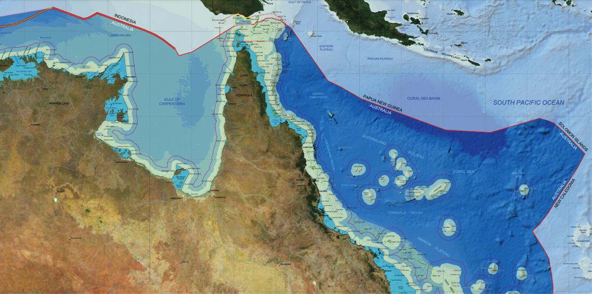
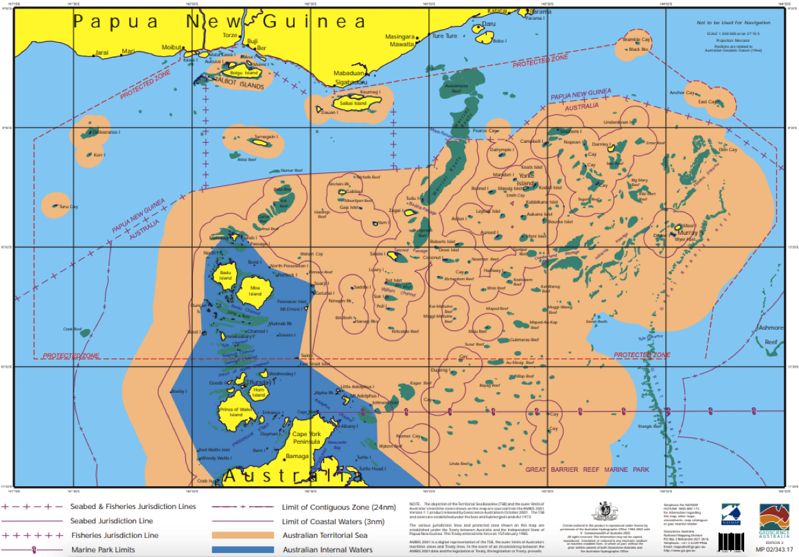
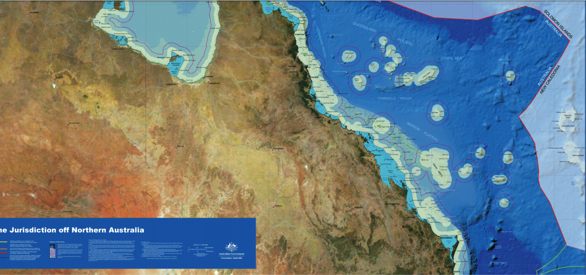
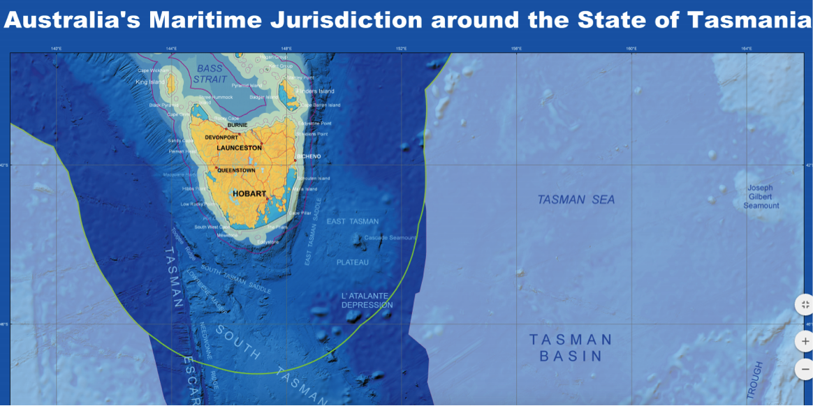
We have included the sea up to the Australia's Exclusive Economic Zone Limit maritime boundary in FOWTOR because State and Federal governments have proven over the years since federation that they are incapable of controlling the seas, leaving the seas open to misuse by international fishing corporations and the like, and incapable of controlling the water flowing into the sea from the land, leaving them open to pollution and general environmental damage. FOWTOR seeks to make these mistakes harder to make. The best people to control the seas (as defined here) are the people in control of the states (not current legal entities called Australian States but consequent states (regions) as defined in FOWTOR). They are intimately in contact with FOW into the sea and can make clear decisions on who uses the adjoining seawater, when, and for what purpose. The state would require resources, such as shipping resources, helicopters, planes, drones, etc., to turn this vast area into a protectorate but we know, from attempts to protect the Great Barrier Reef GBR, that would be money well spent. All seas around Australia have GBR type considerations. They are just not taken into consideration because the concept of protectorate only occurs in the minds of CSIRO scientists who the national government seems keen to sack now anyway. The Federal and the State governments have never taken this protectorate seriously, not setting aside any serious resources to make it happen. The police watercraft in the large cities on the coast and the country's naval resources are engaged in completely different functions than we are talking about under FOWTOR. These changes turn Australia's Exclusive Economic Zone Limit into real state resources rather than just an international claim for power and prestige, huge international capital largesse and so-called 'security' issues usually dictating naval mismanagement by a national government concerned only with political issues and largely unconcerned with the use of the seas surrounding the continent. As the sealevel rises (as it is about to do as global warming increases) FOWTOR states are also best placed to ameliorate the risks associated with rising sea levels. The existing State and National governments may make important changes to protect significant urban conurbation, such as Melbourne, Sydney, Wollongong, Newcastle Brisbane, The Sunshine Coast, Adelaide, Perth, from rising sea levels. But following the massive bushfires across Australia in 2019, it is reasonable to assume that when the impact of sea level rise becomes significant, regional areas will be left to 'fend for themselves'. The story will be the government simply does not have the resources to protect everyone around a vast continent with such a small population. We have to make decisions to use those resources carefully according to priority. We can hear it already. FOWTOR makes these sorts of mitigations at the state level more understandable and achievable. The most external national boundary (defined by federal jurisdiction) defines a number of international borders, including borders with: Indonesia, Timor-Leste, Papua New Guinea, Solomon Islands, New Caledonia (Nouvelle-Caledonie), New Zealand. (See maps below). The state maritime boundaries define a border (with other states),. Under FOWTOR, each state has borders with at least 2 other states, most have borders with 3 other states, and 3 states have borders with a multiplicity of other states. The external national border defines the need for the federal government's navy to use a zone of indeterminate width inside the Australia's Exclusive Economic Zone Limit limit when dealing militarily with international shipping to protect national interests. This use of this bordersea by the National navy within the Australia's Exclusive Economic Zone Limit the FOWTOR state will of course be required to permit under agreed negotiation and transparency and duty of care provisions agreed at the time of Allocation. All shipping not engaged by the naval forces as described here would naturally be a FOWTOR state concern and fall under state jurisdsiction. This makes complete sense because the existing States' and Federal jurisdictions have shown themselves to be incapable of making even basic decisions to stop international and large corporations using shipping lanes to wreak havoc on the environment such as their open engagement in damaging the Great Barrier Reef with no care for the future, and little or no penalty arising. |
The terms border and borderland are synonyms. They are both zones of indeterminate width that form the outermost parts of a country, that are bounded on one side by the national boundary. Lapradelle called such zones le voisinage, meaning neighbourhood, vicinity, nearness, neighbours. He also uses the term le territoire limitrophe translated as the neighbouring or bordering area. P&T(2008). p.12 Lapradelle, P. de, 1928. La frontière: etude de droit international [The boundary: a study of international law], Les Éditions Internationales: Paris. This historical surge in drawing boundaries on land has been matched since the 1940s by what Eckert (1979) has called ‘The enclosure of the oceans’. Since 1947 countries have claimed waters and seabed within 200 nautical miles of their coasts. In some cases claims to the seabed extend beyond this limit. P&T(2008). p.13 Ekert, R.D., 1979. The enclosure of the oceans, Hoover Press: Stanford.
|
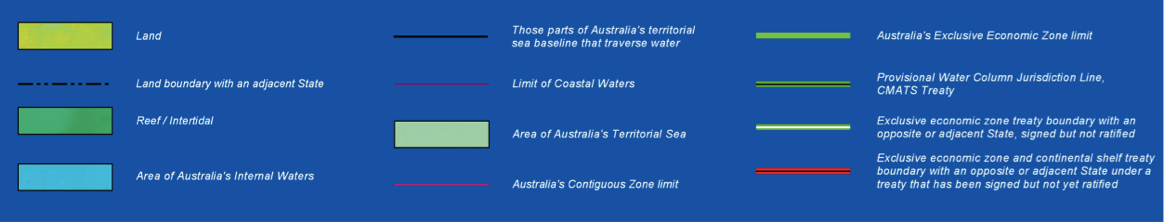
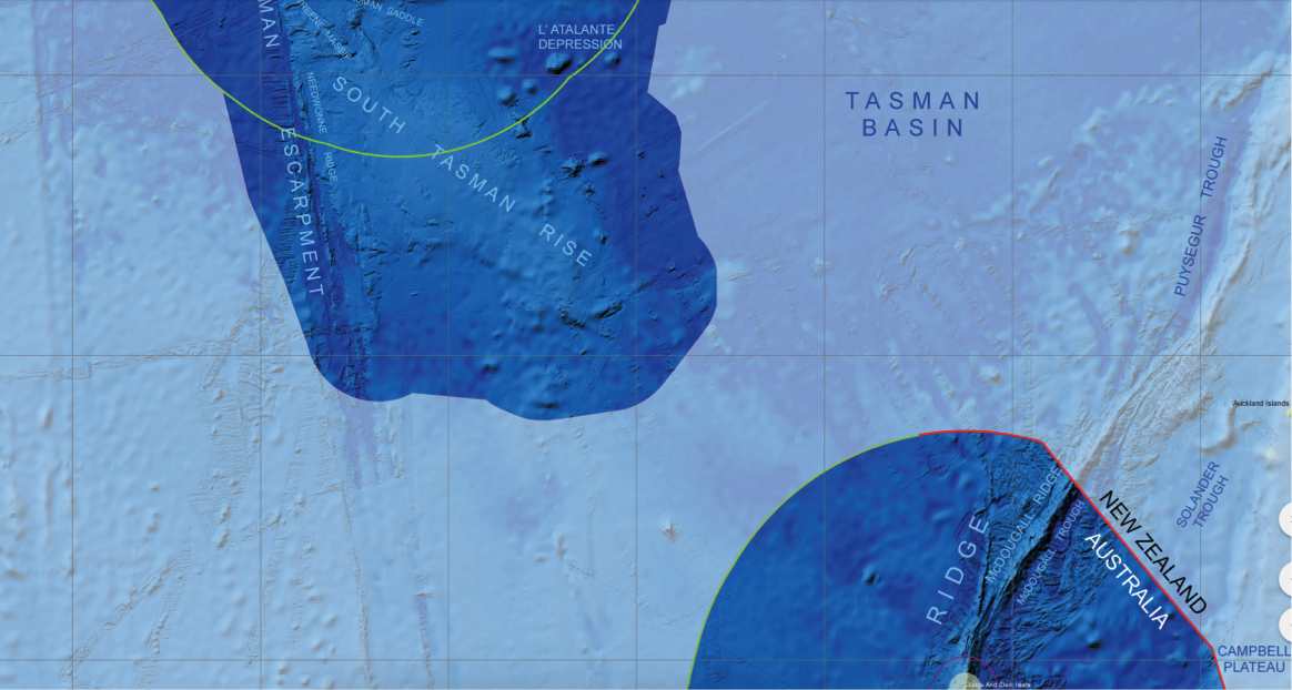
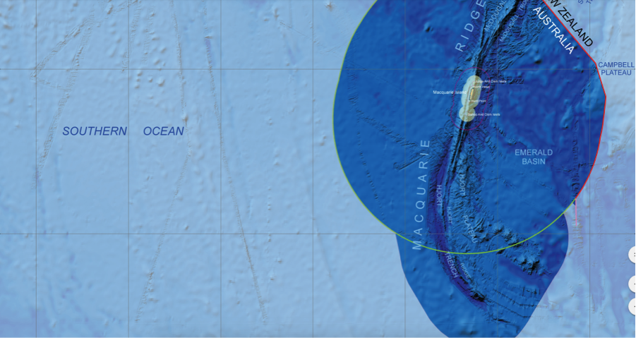
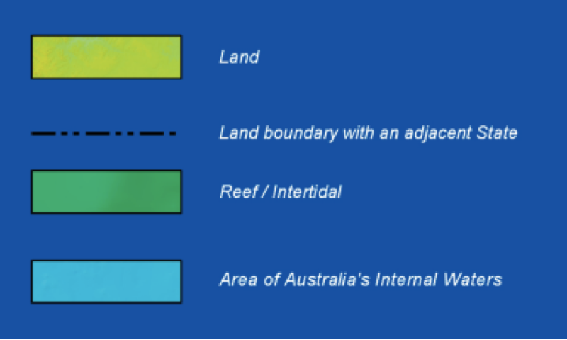
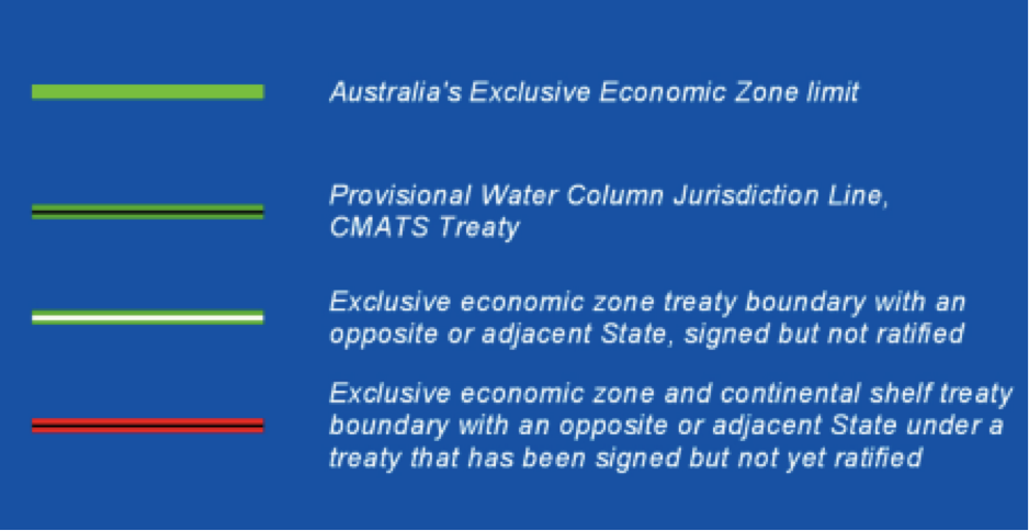
Australian Government: Key International Boundaries & Borders
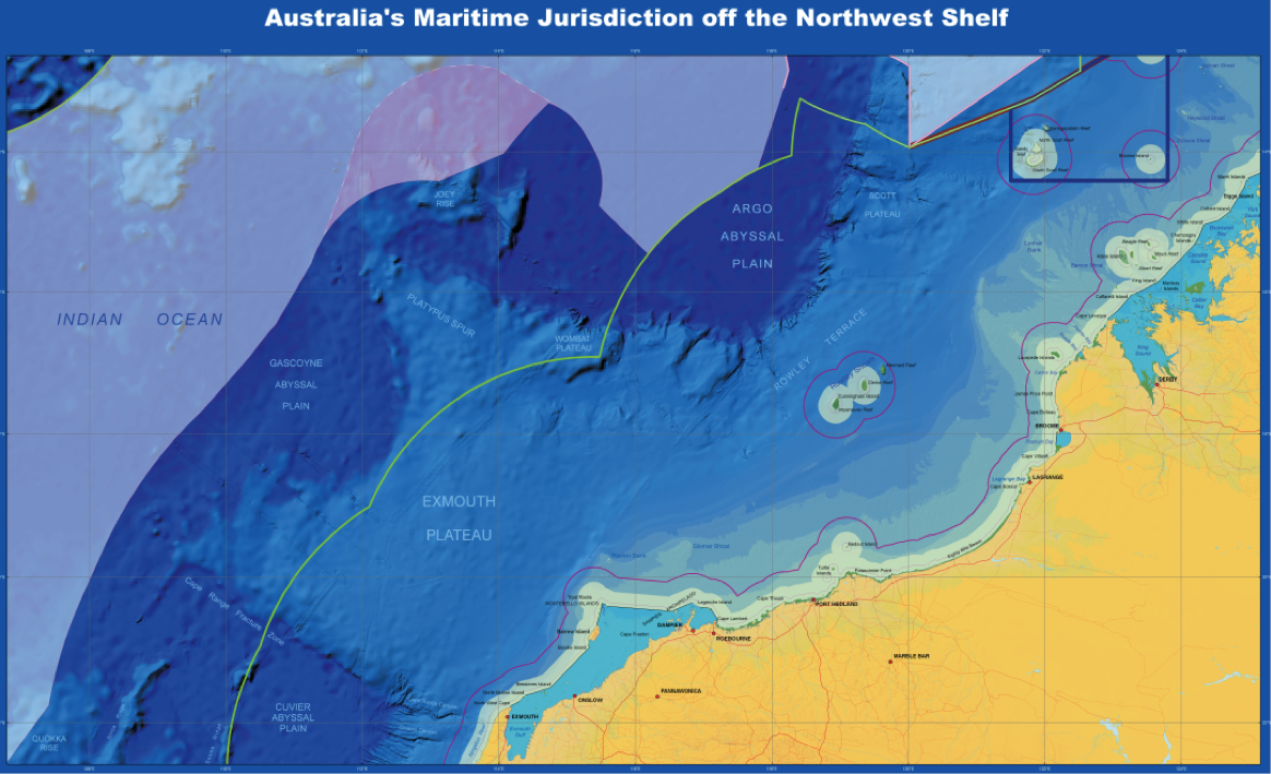
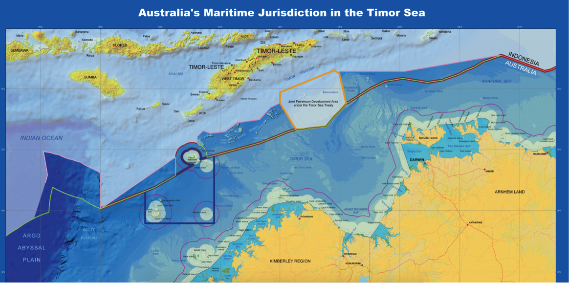
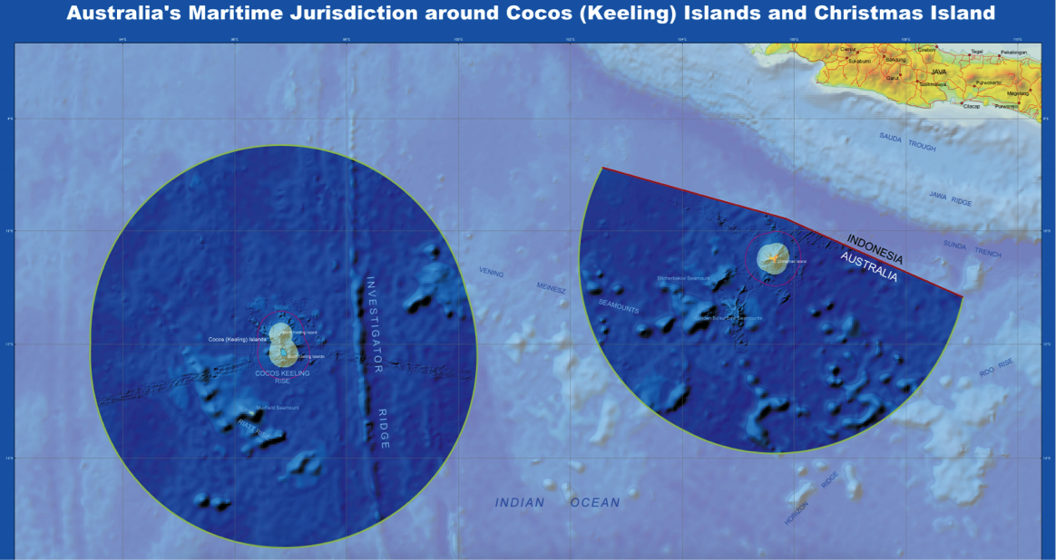
The following International boundaries given us by Geoscience Australia describe twelve key boundaries defining Australia's Maritime Jurisdiction north and south.
 |
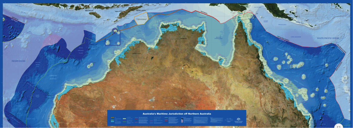 |
Australian Government: Geoscience Australia: https://d28rz98at9flks.cloudfront.net/70183/AMJ_70183.pdf
 |
 |
Australian Government: Geoscience Australia: https://d28rz98at9flks.cloudfront.net/70183/AMJ_70183.pdf
 |
Australian Government: Geoscience Australia: https://d28rz98at9flks.cloudfront.net/69341/AMJ_69341.pdf
 |
Australian Government: Geoscience Australia: https://d28rz98at9flks.cloudfront.net/68796/AMJ_68796.pdf
 |
Australian Government: Geoscience Australia: https://d28rz98at9flks.cloudfront.net/70099/AMJ_70099.pdf
 |
Australian Government: Geoscience Australia: https://d28rz98at9flks.cloudfront.net/70183/AMJ_70183.pdf
.png) |
Australian Government: Geoscience Australia: https://d28rz98at9flks.cloudfront.net/70183/AMJ_70183.pdf
 |
Australian Government: Geoscience Australia: https://d28rz98at9flks.cloudfront.net/42317/42317.pdf
 |
Australian Government: Geoscience Australia: https://d28rz98at9flks.cloudfront.net/70183/AMJ_70183.pdf
 |
Australian Government: Geoscience Australia: https://d28rz98at9flks.cloudfront.net/70315/AMJ_70315.pdf
 |
Australian Government: Geoscience Australia: https://d28rz98at9flks.cloudfront.net/70315/AMJ_70315.pdf
 |
Australian Government: Geoscience Australia: https://d28rz98at9flks.cloudfront.net/70315/AMJ_70315.pdf
Australian Government: 20 Key International Boundary Lines
The above mapping of International boundaries by Geoscience Australia throws up 20 key international boundaries. If a FOWTOR State has a maritime boundary, it will obviously be chosen from this list.
 |
 |
 |
 |
 |
Australian Government: Geoscience Australia: https://d28rz98at9flks.cloudfront.net/70183/AMJ_70183.pdf
Drawing Boundaries
| FOWTOR Model | International |
|
The motives for drawing FOWTOR state boundaries on land and sea are identical for each state but multiplicitous, meaning they arise from the need to satisfy a multiplicity of human needs for those who reside in the state. This includes concepts such as title and the nature of human and material resources, but is not limited to that. If the existing State model is replaced by the FOWTOR model it is because of the need to take into account the past, the present, and the future of communities living in the state, which includes human needs at the personal, community, and state levels, including le voisinage, meaning (in international nomenclature): our neighbourhood, in our vicinity, determined by nearness, our neighbours, with whom we have, we seek to have, good neighbourly relations. For the descendants of Indigenous communities the past history of their communities has been removed from the record of settlement. This means that Title is only meaningful if a full rewriting of the historical record is carried out so that the resulting title is acceptable to all parties, especially Aboriginal and Torres Strait Islander communities. If this means a formal treaty is required to bring it about, so be it. Of course, Title will satisfy many of the current needs, but not all. The quality of life for all sections of the community is paramount. Housing and health and social security, needs for support at the state level. And the future of the state including future of community life, le voisinage, rising sea levels and electricity from sun and wind and other future concerns, all necessary at this conjuncture; a moment of existential crisis for the whole of humanity on the planet. While the FOWTOR Model calls for the boundaries to be drawn by academia, at the professorial level, by experts in geoscience, to draw the boundaries for proper FOW that makes sense into the long term future, all communities need to be engaged, to allow this to be a new beginning across the continent. |
The motives for drawing international boundaries on land and sea are identical. States wish to secure a clear and unchallenged title to parts of the earth, that are valued for the human or material resources they contain or the strategic advantage that they confer. They also seek to create lasting arrangements with neighbours that will, at least, minimize the risk of friction either between governments or citizens. P&T(2008). p.13 Lapradelle called such zones le voisinage, meaning neighbourhood, vicinity, nearness, neighbours. He also uses the term le territoire limitrophe translated as the neighbouring or bordering area. P&T(2008). p.12 Lapradelle, P. de, 1928. La frontière: etude de droit international [The boundary: a study of international law], Les Éditions Internationales: Paris. |
States: Choosing A Key State Maritime Boundary
| FOWTOR Model | International |
|
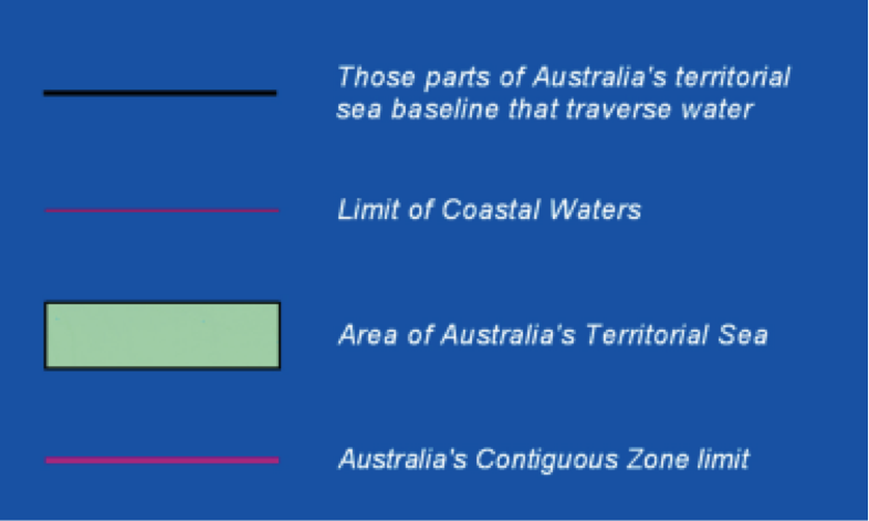
There are three possible State Maritime Boundaries to be considered from the National Maritime Boundaries. Only one makes complete sense to FOWTOR. The other two are nonetheless viable options. (a) External limitation of Australia's Territorial Sea. If this is included in a new form of statehood (that is, regionalism) this puts reefs etc. under the #dutyofcare of the FOWTOR state, in a protectorate under the control of the new state and incorporating it in the region's particularities, it's past, present, and future. Current Federal and State governments have proven over the last 119 years that local FOWTOR states are needed to get control of such essential elements. Recent federal sacking of CSIRO scientists and money flowing to private NGOs who have no interest and haven't even applied are good examples of things needing quick turnaround before sea level rise (which is happening as we speak) gets severe. (b) Australia's Contiguous Zone Limit. Based on (a), just wider. Abitrary and meaningless but better than (a) for the new state. (c) Australia's Exclusive Economic Zone Limit. The federal Government has shown its main interests are international capitalist main deals such as dealing with mining conglomerates etc. The state owning and controlling the whole of the areas defined opens up the possibilities, a broad exciting new future to statehood (regionalism) in Australia. |
There is one important difference faced by In the sea, the 1982 Convention permits coastal |
States: Allocation, Delimitation, Demarcation, Administration
| FOWTOR Model | International |
|
In the FOWTOR model, the terms allocation, delimitation, demarcation and administration have precise meanings: Allocation means the initial political division between two states under FOWTOR. If that happens under the Australian Constitution 1901 without significant change to that Constitution, allocation means an agreement brought about by particular meetings of the COAG, brought together by and necessarily participated in by all existing states and territories and the federal government, for the purpose of Allocation, and verified by Referendum(s) as necessary, given the existing Constitutions of all the participating bodies (federal, states, and territories). Allocation means the abolition of existing states and territories and their replacement with 31 states based on "new regional division of the continent based on the flow of water". They are still states in the sense as outlined in the original Constitution 1901. We have looked at the Constitution and few words need to change. It is just replacing existing States with 31 new states and removing any consideration of separate territories under the Constitution. Such a change would require a referendum and would require those needed for repeal of State Constitutions and their replacement with identical State Constitutions. The generic name 'state' could be altered to 'region' in any referendum being conducted to change Constitution 1901 to achieve Allocation as detailed above. Minimal changes would be necessary to achieve this renaming. This alteration is not considered meaningful nor necessary. The only benefit might be the general understanding among those being called upon to support Allocation in referendums of 'regionalism' as a serious, meaningful and useful concept that replaces the meaningless, political, legalese 'statehood' used in the formation of the federation by agreeing on the Constitution 1901. A real step forward; a bit like Constitution Alteration (Aboriginals) 1967; one of a few since federation. If Allocation occurs under a major change to the Constitution, for example its replacement with a completely new Constitution to replace head of state with an elected President and creation of a separate independent Republic, regionalism will still be important because the needs of populations and communities in each region are separate and distinct and in some senses unique to the new state referred to in FOWTOR and the satisfaction of those needs cannot be achieved simply by the abolition of states under the Constitution, old or new. We know this because existing State governments arbitrarily drawn, politically defined, and agreed at the moment of formation 1901, have found it difficult, if not impossible, to properly deal with the histories, needs, rights, and responsibilities of particular and diverse existing communities within their existing state boundaries. It would be absurd to imagine that this problem would disappear if States were abolished and the whole of these matters were brought under a national government treating all communities under its care and control with equal concern. We expect issues like this to play a significant part in the campaigns for the formation of a Republic and therefore little more needs to be said here. Delimitation means the selection of a boundary site and its definition. In the FOWTOR model, each state has an identical and simple definition, unlike the States it is seeking to replace: Because it is based on the Flow Of Water (FOW), from the highest achievable lineage that encompasses the boundary site (delimited by the Top Of Ridge (TOR)) to the sea, it is defined by natural processes, not by political negotiation. The definition at sea level is also reasonably easy to determine. Where the boundary on the land hits the sea, at two points, each end of this line, a straight line is drawn out to sea, at as near to 90 degrees to the shoreline as is practicable, until it (the state maritime boundary) hits the national maritime boundary (which delimits the whole continent that falls under the jurisdiction of federal law from the high seas). The area delimited by the water within those maritime boundaries is naturally part of the state boundary site and is contained within that state's jurisdiction under Constitutional law. Demarcation refers to the construction of boundary markers in the landscape: Because boundaries are determined by FOW, few boundary markers are required in practice. They may occur on a road that crosses the TOR at a border crossing with another state and may be indicated by markers on the road or signage etc. It is not considered appropriate for fences, walls or barriers to occur at TOR as this would interfere with the proper environmental management of FOW. It would also be unconstitutional for tracks, roads, pavements, ditches, watercourses, powerlines, etc to be constructed at the top of the TOR, and/or to follow the, TOR dividing two states. Demarcation needs to be a natural feature of the landscape and to remain so in perpetuity. TOR is easily determined by inspection on the ground by observing the FOW to determine which state we are in. A geographical map of the boundary site, drawn up by geographers, will demarcate the boundary with an accurate, continuous encompassing line at the TOR from coast to coast, and, once agreed by the COAG, will become final and permanent. Political negotiations cannot change this demarcation in an attempt to modify the political, economic, or social attributes of the state existant at the time of original Allocation to achieve other purposes. The only change in the future might be the division of a state or the amalgamation of two states if considered appropriate to achieve the proper control of the FOW. A bit like "we got it wrong in Allocation; it should have been ..." It's not so easy when at sea to understand which state jurisdiction you are under when inside the maritime boundary. There are no markers to tell you what state you're in. But this is no different under FOWTOR to any other system of current border control. And with sophisticated Global Satellite calculation and imagery systems dominating the use of vessels these days, this is just a technical issue. It probably makes more sense under FOWTOR, anyway, as security control systems, for example, are closer to those rorting the system, rather than security systems hundreds of nm's away, being called on to take action. Finally administration is concerned with the maintenance of those boundary markers for as long as the boundary exists. The boundary marker (the TOR) is a natural occurring phenomenon. Of course, engineering being what it is in the twenty-first century, the TOR can be changed dramatically for profiteering and political purpose. If the FOWTOR model is used to define a new form of regionalism in Australia, it will become unconstitutional to physically modify the landscape to bring about changes to the TOR so that the FOW is changed, thereby changing the boundaries of two adjacent states, requiring modification of the original detailed geological survey. Where this happens naturally it is expected this will involve minor changes over long periods that can easily be dealt with by both states coming to agreement with the federal government as arbitrator. |
The terms allocation, delimitation, demarcation and administration have the precise meanings that Lapradelle and Jones developed. Allocation means the initial political division between two states. Delimitation means the selection of a boundary site and its definition. Demarcation refers to the construction of boundary markers in the landscape. Finally administration is concerned with the maintenance of those boundary markers for as long as the boundary exists. P&T(2008). p.12 Jones. S.B., 1945. Boundary-making, a handbook for statesmen, treaty editors and boundary commissioners, Carnegie Endowment for International Peace: Washington DC. |
Boundaries: Cultural Landscapes: Antecedent, Pioneer, Subsequent, Consequent
| FOWTOR Model | International |
|
In the FOWTOR model, the terms antecedent, pioneer, and subsequent are meaningful: An antecedent boundary is a boundary that was drawn before most of the features of the current cultural landscape existed. A subsequent boundary is a boundary that was constructed on an existing cultural landscape. We have no way of knowing what antecedent boundaries divided the continent over the last 60,000 years. But it seems obvious, given the enormous complexity of subsequent boundaries shown on the map of the nations https://www.bloggerme.com.au/aboriginal-australia-map1 that there were many in place before it came to the level of complexity shown in the map, which in a sense represents a snapshot of nationhood in the minds of Indigenous communities, where it had developed to, before it was, ruthlessly, without any care for what existed at that moment or what had existed before, destroyed by the colonialists. While the FOWTOR model is offering new boundaries, it seeks to take into account. with due respect, the subsequent boundaries of the original inhabitants prior to 'settlement'. When you compare their map with the FOWTOR map, many of the boundaries are exactly the same. They just have more because the communities occupied smaller areas, than are meaningful today. The similarity in the broader sense is startling and real. It seems obvious that this similarity is there because the subsequent boundaries of Indigenous and Torres Strait islander communities (nations), that is to say subsequent to social community development over 60,000 years or so, were influenced by the FOW. Boundaries that are drawn to coincide with some physical or cultural features are called consequent. All boundaries in the FOWTOR Model are consequent boundaries. They are consequent to the FOW. We do this, not only because of the importance of water to all life on the continent, an extremely arid continent, the most arid of all continents on the planet, that needs proper management of water to survive. We do it also because it helps to give proper meaning to regionalism that was completely destroyed by the meaningless political borders agreed to at the time of drawing up the boundaries in the late C19th giving rise to the Constitution 1901. The FOWTOR state boundary describes a region that is unique, distinct from all the other states that make up the continent. Antecedent colonial Statehood hid this uniqueness from view and turned the management of the various regions, the management of regional communities, the management of water, the management of communities' human rights and responsibilities, etc. into a political football to be played by those in power for their own purpose and their own outcomes. If a line was drawn through an uninhabited area the term pioneer boundary is appropriate. Boundaries drawn up by colonialists as 'new states' in the mid C19th were seen as pioneer, but that's only if you accept the idea that the continent was 'uninhabitated', 'unpopulated', which nobody accepts today. In the FOWTOR model there are no pioneer boundaries. |
Lastly Hartshorne (1936) proposed some useful Hartshorne, R., 1936. ‘Suggestions on the terminology of political boundaries’, Annals, Association of American Geographers, 26, 56-7. |
Boundaries: Cultural Landscapes: Superimposed, Discordant
| FOWTOR Model | International |
|
A boundary drawn on an existing cultural landscape, that appears to be unrelated to the cultural features, is called superimposed or discordant. As mentioned above, the boundaries of the colonialists were established by frontiers moving out from a landing point for all colonies around the continent with no knowledge or concern for, and being superimposed over, existing Indigenous boundaries that had been in place by communities for thousands of years. These were discordant in the sense that they were opposed by Indigenous communities, acts brutally imposed and defended by colonialists, resulting in genocide in huge numbers. The boundaries drawn up by the colonialists as they established Statehood were superimposed boundaries. These superimposed boundaries, establishing 'properly defined' Statehood, played a huge role in extended genocide. Their purpose was an imposed 'legitimacy' by the British monarchy, a legitimacy that continues via the Constitution 1901 to this day. As stated above it is obvious that drawing up Pioneer boundaries was a lie, because the colonialists denied any existence of Antecedent boundaries. If they had recognised Antecedent boundaries they would have been involved in imposing Subsequent boundaries (with agreement) or Superimposing Subsequent boundaries (on Discordant populations). In either case a treaty would have been seen as necessary. Of course after 'occupation' the colonialists did think they were engaged in Allocation, Delimitation, Demarcation, and Administration. The existing Indigenous population saw it as Superimposition, and in a sense both sides still see it that way today. It seems clear that this issue will only ever be resolved by treaty. Much of the descendant Indigenous populations are calling out for negotiations on a treaty. For their part, the National Government shows no willingness to move in the direction of resolution. This means that to be successful FOWTOR needs support from all sides of a difficult and poorly defined debate. This white paper is being prepared to try add some definition and maybe in the longer term win support across all platforms. It is not trying to play Mr. Nice Guy, appealing to all sides. Boundaries, borders and frontiers are difficult and complex terms and no good will come of that. We need to tell like it is. |
A boundary drawn on an existing cultural landscape, that appears to be unrelated to the cultural features, is called superimposed or discordant. P&T(2008). p.12 |
Boundaries: Cultural Landscapes: Relict
| FOWTOR Model | International |
|
A relict boundary is one that has been abandoned but is still marked by differences in the landscape that developed during its lifetime. Previous boundaries in communities prior to 'settlement' are known (such as those shown in the Aboriginal map). https://www.bloggerme.com.au/aboriginal-australia-map1 Work is being done to understand previous communities and historical realities of 'settlement' such as genocidal attrocities. As this develops in Australian academia, we are certain that relict boundaries will become more apparent. FOWTOR seeks to turn all existing boundaries, all boundaries defining States and Territories currently making up the federal landscape, into relict boundaries. New states under FOWTOR should take the marking of all relict boundaries, Indigenous and pre-existing federal boundaries, in the landscape of the new state, seriously, as a useful way of telling future generations a history of previous social connection across the continent. |
Finally a relict boundary is one that has been abandoned but is still marked by differences in the landscape that developed during its lifetime. P&T(2008). p.12 |
Other interests that may be included in a subsequent discussion document that goes along with this one:
Histories (Nations, Colonies, States, Federation, Modern International Nation States)
1. Pre-colonial: Local 'Nations' history & Inter-Nations Diplomacy
2. Colonial era: 'National' history, Inter-colonial 'diplomacy': mainly world wars at the time of 'Settlement'
3. Local 'Nations' vs Colonies, diplomacy vs genocide
4. Pre-Federation diplomacy: Governors & States, Capitals
5. Pre-Federation diplomacy, local colonies vs English Crown, Carving Up, Stright-line theorists
6. Federal diplomacy: Formation
7. Federal international diplomacy: Pre-WWI
8. Federal international dimplomacy: Post WWI
9. Federal international diplomacy: Post WWII
10. States' international diplomacy: Pre End of Crown
11. States' international diplomacy: Post End of Crown
12. Nations diplomacy: Recognition, Sovereignty, Treaty
13. Modern International Nation States: Strategic Dependence vs Acquired Sovereignty (Independent foreign policy)
Other reads:
Iain Davidson, Heather Burke, Lance Sullivan, Lynley A. Wallis, Ursula Artym & Bryce Barker Cultural conflict in text and materiality: the impact of words and lead on the northwest Queensland colonial frontier, Australia https://www.tandfonline.com/doi/10.1080/00438243.2020.1711153 https://doi.org/10.1080/00438243.2020.1711153 pp. 724-740 | Published online: 20 Jan 2020
Iain Davidson, Heather Burke, Lance Sullivan and Lynley Wallis: Archaeology on the Frontier This blog is about research relating to frontier conflict and especially the Native Mounted Police in Queensland Murdering - Molvo Part I: The Events at Wonomo Waterhole https://archaeologyonthefrontier.com/2020/07/13/murdering-molvo-part-i/
Add new comment