Submitted by jenny999 on Thu, 05/10/2023 - 9:09am
Title for Wurung Region: "Navigating the Waters of Wurung: Sustaining the Gulf and Basin Connection"
I. Introduction
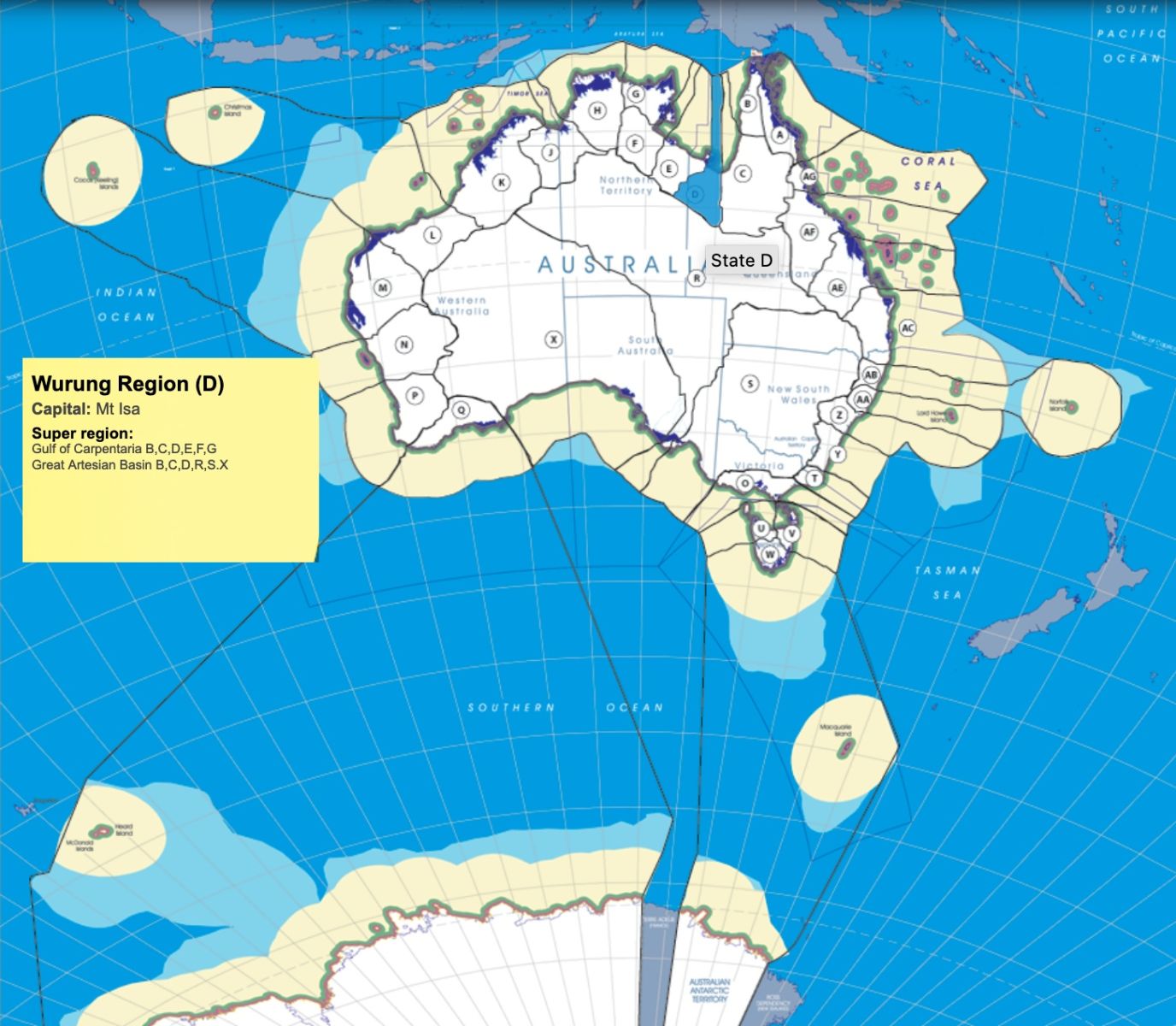
- Introduce the Wurung Region, highlighting its significance as a region within Queensland (QLD) and a member of the Gulf of Carpentaria and Great Artesian Basin super regions, with Mount Isa as its capital.
- Emphasize the region's unique characteristics and the central role of its defining waterways, including the Nicholson, Leichhardt, and Albert Rivers.
II. Gulf of Carpentaria and Great Artesian Basin
- Provide an overview of the Gulf of Carpentaria and Great Artesian Basin, highlighting their ecological importance, water resources, and their influence on the Wurung Region.
- Discuss the significance of these super regions in shaping the Wurung Region's identity.
III. Flow-of-Water Top-of-Ridge (FOWTOR) Framework
- Explain how the Nicholson, Leichhardt, and Albert Rivers define the boundaries of the Wurung Region within the FOWTOR framework.
- Stress the relevance of the FOWTOR model in managing water resources, fostering regional connections, and ensuring environmental sustainability.
IV. Governance and Representation
- Governance and Representation
- Regional Capital: Each FOWTOR region should have a designated regional capital, which serves as the administrative center for that particular region. This capital city or town is responsible for coordinating regional activities, liaising with state and local governments, and representing the region's interests at the federal level. It acts as the hub for regional decision-making and administrative functions.
- Describe Mount Isa as the regional capital responsible for administrative coordination and governance activities within the Wurung Region.
- Highlight the importance of effective governance in addressing regional challenges and opportunities.
-
Indigenous Representative Body (The Voice): To ensure that the FOWTOR region's interests are effectively communicated and advocated at the federal level, a representative body known as "The Voice" can be established. This body comprises elected representatives from the region, who are responsible for articulating the region's needs, concerns, and priorities to the federal government in Canberra.
The Voice serves as a direct link between the nations in the FOWTOR region and the federal government, advocating for policies, resources, and investments that align with the region's 13 objectives. These objectives encompass various aspects, including natural resource management, infrastructure development, social services, and Indigenous rights.
- By establishing a regional capital and The Voice, the FOWTOR model ensures that each region has a structured approach to engage with federal, state, and local governments. This political framework empowers regions to have a voice in the governance process, advocate for their unique needs, and work collaboratively with various levels of government to achieve their objectives.
V. 13 regional Objectives
- Present the 13 key objectives specific to the Wurung region, covering areas such as natural resource management, infrastructure development, social services, and cultural preservation.
- Emphasize the importance of aligning policies and resource allocation with these objectives for regional advancement.
-
The Flow-of-Water Top-of-Ridge (FOWTOR) model is a comprehensive framework for regionalism in Australia that considers various aspects of geography, environment, and development. This model is based on the natural flow of water along ridges and encompasses the following key elements:
-
(1) Natural Resource Management: FOWTOR-based regionalism informs strategies for managing Australia's diverse natural resources within distinct watershed regions. These regions are essential for safeguarding unique ecosystems and wildlife habitats.
-
(2) Water Resource Allocation: By delineating watersheds along ridges, FOWTOR analysis aids in the equitable allocation of water resources across the country. This ensures sustainable use and minimizes conflicts in agriculture, industry, and urban areas.
-
(3) Climate Adaptation Planning: Different FOWTOR regions exhibit varying climate patterns and vulnerability to climate change impacts. Regionalism guides climate adaptation plans, tailoring strategies to address specific challenges in each region.
-
(4) Agricultural Zoning: FOWTOR-based regionalism assists in zoning for agriculture, aligning land use with natural water availability and soil quality. This approach promotes efficient and sustainable agricultural practices.
-
(5) Biodiversity Conservation: Prioritizing biodiversity conservation is a core component of the FOWTOR model. It identifies regions with unique ecosystems or high levels of endemism as targets for conservation efforts.
-
(6) Land Use Planning: When planning urban and rural development, FOWTOR regionalism helps identify suitable areas for settlement while considering factors like water availability, flood risks, and environmental sensitivity.
-
(7) Disaster Risk Reduction: Understanding water flow along ridges is essential for mitigating flood risks and planning disaster-resistant infrastructure in flood-prone areas.
-
(8) Indigenous Land Management: Incorporating FOWTOR-based regionalism into land management practices respects the Indigenous knowledge of local environments, fostering a holistic approach to land stewardship.
-
(9) Tourism Planning: FOWTOR analysis is invaluable for tourism planning, as it highlights unique natural attractions and recreational opportunities within each region, promoting sustainable tourism development.
-
(10) Social Infrastructure: FOWTOR regionalism extends to the categorization of settlements, including hamlets, villages, towns, and cities. This classification ensures that social infrastructure and services are appropriately scaled to meet the needs of local communities.
-
(11) Indigenous Infrastructure: Recognizing the original nations and their territories within FOWTOR regions is fundamental to acknowledging and preserving Indigenous heritage and cultural connections.
-
(12) Connection Superstructure: The model considers the development of road networks, railways, ferry routes, and air transportation systems to facilitate connectivity and accessibility within and between FOWTOR regions.
-
(13) River Water Flows into the Sea: Understanding the path of river water as it flows into the sea is crucial for managing water resources and preserving aquatic ecosystems at the maritime border of each FOWTOR region within the Australian Economic Zone.
-
By incorporating these additional elements, the FOWTOR model provides a comprehensive framework for regional planning and development in Australia, encompassing natural, social, Indigenous, and infrastructural aspects while respecting the country's unique geographic features and environmental diversity.
- Present key objectives specific to the Wurung Region, focusing on sustainable water management, ecological conservation, cultural heritage preservation, and regional collaboration.
- Emphasize the importance of aligning policies and resource allocation with these objectives for sub-regional prosperity.
V. Indigenous Engagement
- Acknowledge the Indigenous heritage within the Narrabeen region and the significance of cultural preservation and community empowerment.
- Describe initiatives aimed at involving Indigenous voices in regional development and respecting cultural traditions.
-
Key Responsibilities of The Voice:
-
(1) Advocacy: The Voice articulates the FOWTOR region's needs and priorities to federal policymakers and agencies, advocating for policies that support regional development and sustainability.
-
(2) Resource Allocation: It plays a crucial role in securing federal funding and resources for regional projects and initiatives, ensuring equitable distribution based on the region's unique requirements.
-
(3) Policy Development: The Voice actively participates in the development of federal policies and legislation that impact the region, offering insights and recommendations that reflect the region's interests.
-
(4) Coordination: It facilitates coordination between federal, state, and local governments to ensure seamless implementation of policies and projects within the region.
-
(5) Community Engagement: The Voice engages with the local community to gather input, gather feedback, and involve residents in decision-making processes that affect the region.
-
(6) Monitoring and Evaluation: It monitors the progress of projects and initiatives within the region, assessing their impact on the 13 objectives, and making adjustments as needed.
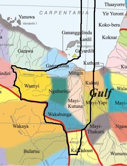
NOTE1: Likely indicators only; for original Aboriginal Australia Map © 1991 & restrictions on its copy & use, see Aboriginal Australia Map
NOTE2: The red line is part of the original Aboriginal Australia Map © 1991. The black line is added by Bloggerme for discussion only. It shows the likely State boundary based on the flow of water only. As "the ridge" (See FOWTOR) naturally impacts on the development of the language, social or nation groups of the Indigenous people of Australia, the proposed border is often identical to the group boundary shown on the Aboriginal Australia Map. This is as was expected. Variations are social/historical & result in a particular language, social or nation group being represented in two adjoining States.
VI. Sustainable Water Management
- Discuss the region's commitment to sustainable water management practices, highlighting responsible water use, groundwater conservation, and river ecosystem health.
- Emphasize the role of the Nicholson, Leichhardt, and Albert Rivers in supporting local communities and agriculture.
VII. Ecological Conservation
- Address the region's dedication to ecological conservation, emphasizing the protection of riverine habitats, wetlands, and native species.
- Showcase initiatives aimed at conserving vital ecosystems and preserving biodiversity.
VIII. Cultural Heritage Preservation
- Acknowledge the cultural heritage within the Wurung Region, including Indigenous sites and historical landmarks.
- Describe initiatives aimed at involving Indigenous voices, celebrating cultural traditions, and promoting responsible tourism.
IX. Regional Collaboration
- Highlight the Wurung Region's role in fostering collaboration with neighboring regions, Indigenous communities, and stakeholders to address shared challenges and opportunities.
- Discuss the importance of regional connectivity and cooperation.
X. Disaster Resilience
- Explain how the region addresses disaster risks, including droughts, bushfires, wind, floods, and water quality issues within the Wurung region. These include anticipated continuous sea level rise, temperature rise, and increased extreme events including changing weather patterns, some of which it is impossible to forecast because of those changing weather patterns and most of which has causes outside the control of action for risk mitigation.
- Highlight initiatives aimed at ensuring the safety of communities and the protection of natural assets.
XI. Economic Growth and Sustainability
- Discuss the region's focus on sustainable economic development, including industries such as agriculture, mining, and tourism.
- Emphasize the importance of balancing economic growth with environmental stewardship.
XII. Community Prosperity
- Highlight the region's efforts in fostering community prosperity through social programs, education, healthcare access, and cultural preservation.
- Emphasize the importance of community well-being for long-term sustainability.
XIII. Policy Recommendations
- Summarize key policy recommendations tailored to the Wurung Region, aligned with the FOWTOR framework and sub-regional objectives.
- Advocate for policies that prioritize sustainable water management, ecological conservation, cultural heritage, and regional connectivity.
XIV. Conclusion
- Reinforce the region's commitment to navigating the waters of Wurung and its role as a connector of communities, ecosystems, and cultures.
- Express the region's dedication to collaborating with governing bodies, Indigenous groups, environmental organizations, and residents to achieve shared goals.
XV. Acknowledgment
- Attribute the preparation of this outline to AI technology as a modern tool aiding in sub-regional development and cultural heritage preservation.
XVI. Questions and Discussion
- Open the floor for questions, comments, and discussions with relevant political bodies, cultural organizations, environmental agencies, and sub-regional residents to ensure a comprehensive understanding of the region's vision for sustainability and connection.
Add new comment